


TBD Lot 5 Waida Rd Wilson Township, MN 55987
Estimated payment $1,089/month
About This Lot
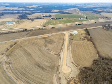
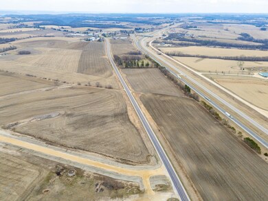
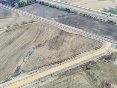
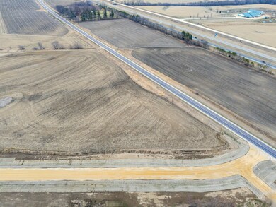
Situated on a total of 210 acres...WAIDA Business Park is located on County Road 12 in Winona Minnesota. Today, we are proud to offer PHASE 1, approximately 26.5 acres of the 210 acres have been rezoned and are ready to build for Industrial and Service/Distribution users. Five lots are currently available ranging in size from 2.81 acres up to 7.94 acres.
Lot 1 - 5.35 Acres. Driveway access from County Road 12
Lot 2 - 2.78 Acres. Driveway access from WAIDA Road
Lot 3 - 3.81 Acres. Driveway access from WAIDA Road
Lot 4 - 7.67 Acres. Driveway access from WAIDA Road
Lot 5 - 7.94 Acres. Driveway access from WAIDA Road
The WAIDA Business Park will become home to industrial and service oriented businesses. This property has excellent potential for manufacturing service, distribution, logistics, flex, industrial, transport terminals, research facilities, executive offices, corporate headquarters and more.
Strategically located, the WAIDA Business Park is adjacent to the main transportation corridor of Southeastern Minnesota. Located between the Winona and Rushford exits on Interstate 90, this property location is well-suited for the continued growth and expansion of Winona and neighboring communities. The WAIDA Business Park is a part of the transportation and infrastructure hub serving the Minneapolis, Milwaukee and Chicago markets.
The WAIDA Business Park offers an unmatched business environment for growth-minded companies. The WAIDA Business Park is a mixed-use development that is ideally positioned for emerging industries as well as traditional business and office users.
Positioned in the heart of Southeastern Minnesota, the WAIDA Business Park offers a high level of connectivity to local and regional markets, easy access to Interstate 90 and a ready supply of labor...all creating the perfect opportunity for business owners seeking the important balance between work and lifestyle.
Property Details
Property Type
- Land
Est. Annual Taxes
- $442
Lot Details
- Zoning described as Industrial
Community Details
- No Home Owners Association
Listing and Financial Details
- Assessor Parcel Number 181000050
Map
Home Values in the Area
Average Home Value in this Area
Tax History
| Year | Tax Paid | Tax Assessment Tax Assessment Total Assessment is a certain percentage of the fair market value that is determined by local assessors to be the total taxable value of land and additions on the property. | Land | Improvement |
|---|---|---|---|---|
| 2025 | $458 | $100,900 | $100,900 | $0 |
| 2024 | $458 | $95,200 | $95,200 | $0 |
| 2023 | $358 | $95,200 | $95,200 | $0 |
| 2022 | $354 | $95,200 | $95,200 | $0 |
| 2021 | $318 | $198,300 | $198,300 | $0 |
Property History
| Date | Event | Price | List to Sale | Price per Sq Ft |
|---|---|---|---|---|
| 04/24/2025 04/24/25 | For Sale | $200,000 | -- | -- |
Source: NorthstarMLS
MLS Number: 6708960
APN: 18.100.0050
Disclaimer: Certain information contained herein is derived from information provided by parties other than Homes.com. All information provided is deemed reliable, but is not guaranteed to be accurate and should be independently verified.
![]() Based on information submitted to the MLS GRID. All data is obtained from various sources and may not have been verified by broker or MLS GRID. Supplied Open House Information is subject to change without notice. All information should be independently reviewed and verified for accuracy. Properties may or may not be listed by the office/agent presenting the information. Some IDX listings have been excluded from this website.
Based on information submitted to the MLS GRID. All data is obtained from various sources and may not have been verified by broker or MLS GRID. Supplied Open House Information is subject to change without notice. All information should be independently reviewed and verified for accuracy. Properties may or may not be listed by the office/agent presenting the information. Some IDX listings have been excluded from this website.
The Digital Millennium Copyright Act of 1998, 17 U.S.C. § 512 (the “DMCA”) provides recourse for copyright owners who believe that material appearing on the Internet infringes their rights under U.S. copyright law. If you believe in good faith that any content or material made available in connection with our website or services infringes your copyright, you (or your agent) may send us a notice requesting that the content or material be removed, or access to it blocked.
Notices must be sent in writing by email to DMCAnotice@MLSGrid.com.
The DMCA requires that your notice of alleged copyright infringement include the following information:
(1) description of the copyrighted work that is the subject of claimed infringement;
(2) description of the alleged infringing content and information sufficient to permit us to locate the content;
(3) contact information for you, including your address, telephone number and email address;
(4) a statement by you that you have a good faith belief that the content in the manner complained of is not authorized by the copyright owner, or its agent, or by the operation of any law;
(5) a statement by you, signed under penalty of perjury, that the information in the notification is accurate and that you have the authority to enforce the copyrights that are claimed to be infringed; and
(6) a physical or electronic signature of the copyright owner or a person authorized to act on the copyright owner’s behalf. Failure to include all of the above information may result in the delay of the processing of your complaint.
- TBD Lot 4 Waida Rd
- TBD Lot 3 Waida Rd
- TBD Lot 2 Waida Rd
- 26085 Frank Hill Rd
- TBD Lot 1 County Road 12
- 0 E Burns Valley Rd Unit 1933975
- 24242 Pfeiffer Hill Rd
- 23146 Highway 43
- TBD E Burns Valley Rd
- 26283 Meadowbrook Ln
- 169 Cobblestone Ln
- 58 Buck Ridge Dr
- 851 6th St W
- 1376 Skyline Dr
- 75 Debi Lei Dr
- 81290 County Road 23
- 8830 E 8th St
- 34506 Pleasant Point Dr
- 8990 Hillside Ln
- 8970 Hillside Ln
- 1555 Homer Rd
- 751 Bluffview Cir Unit 1
- 1258 Randall St
- Hickory Ln
- 456 E Sarnia St
- 287 Orrin St Unit 2
- 307 W Howard St
- 1515 W 5th St
- 67 W Howard St Unit 1
- 53 W 9th St
- 53 W 9th St
- 53 W 9th St
- 1752 W Broadway St
- 419 Olmstead St Unit 2
- 177 E 9th St Unit Upstairs
- 1731 W 5th St Unit 8
- 184 E 9th St
- 915 W 5th St Unit 1
- 221 E 8th St Unit 2
- 867 W 5th St
