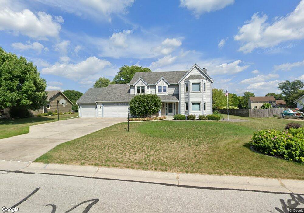
W146N6234 Wigwam Dr Menomonee Falls, WI 53051
Estimated Value: $570,000 - $632,000
4
Beds
3
Baths
2,444
Sq Ft
$246/Sq Ft
Est. Value
About This Home
This home is located at W146N6234 Wigwam Dr, Menomonee Falls, WI 53051 and is currently estimated at $601,109, approximately $245 per square foot. W146N6234 Wigwam Dr is a home located in Waukesha County with nearby schools including North Middle School, Menomonee Falls High School, and Calvary Baptist School.
Ownership History
Date
Name
Owned For
Owner Type
Purchase Details
Closed on
Dec 9, 1996
Sold by
Naughton Luke F and Naughton Elizabeth A
Bought by
Endres Michael A and Endres Deborah O
Current Estimated Value
Home Financials for this Owner
Home Financials are based on the most recent Mortgage that was taken out on this home.
Original Mortgage
$152,000
Outstanding Balance
$15,506
Interest Rate
7.74%
Estimated Equity
$585,603
Create a Home Valuation Report for This Property
The Home Valuation Report is an in-depth analysis detailing your home's value as well as a comparison with similar homes in the area
Home Values in the Area
Average Home Value in this Area
Purchase History
| Date | Buyer | Sale Price | Title Company |
|---|---|---|---|
| Endres Michael A | $212,000 | -- |
Source: Public Records
Mortgage History
| Date | Status | Borrower | Loan Amount |
|---|---|---|---|
| Open | Endres Michael A | $152,000 |
Source: Public Records
Tax History Compared to Growth
Tax History
| Year | Tax Paid | Tax Assessment Tax Assessment Total Assessment is a certain percentage of the fair market value that is determined by local assessors to be the total taxable value of land and additions on the property. | Land | Improvement |
|---|---|---|---|---|
| 2024 | $6,158 | $543,000 | $149,200 | $393,800 |
| 2023 | $5,936 | $543,000 | $149,200 | $393,800 |
| 2022 | $5,880 | $363,100 | $102,700 | $260,400 |
| 2021 | $5,630 | $363,100 | $102,700 | $260,400 |
| 2020 | $5,753 | $354,100 | $102,700 | $251,400 |
| 2019 | $5,513 | $354,100 | $102,700 | $251,400 |
| 2018 | $5,812 | $354,100 | $102,700 | $251,400 |
| 2017 | $5,995 | $354,100 | $102,700 | $251,400 |
| 2016 | $6,081 | $352,700 | $102,700 | $250,000 |
| 2015 | $6,082 | $352,700 | $102,700 | $250,000 |
| 2014 | $6,015 | $352,700 | $102,700 | $250,000 |
| 2013 | $6,015 | $352,700 | $102,700 | $250,000 |
Source: Public Records
Map
Nearby Homes
- N64W14282 Mill Rd
- N64W14182 Mill Rd
- N65W14542 Redwood Dr
- W136N6291 Hummingbird Way
- W140N6628 Florence Ave
- N66W14402 Ash Dr
- N60W13464 Tall Oak Ct
- N63W13412 Hummingbird Way
- N68W14031 Oakwood Dr
- W148N6937 Terriwood Dr
- W130N6462 Crestwood Dr
- W155N6995 Amberleigh Cir
- N67W15832 Tamarack Trail
- W144N7085 Terrace Dr
- W155N7081 Amberleigh Cir
- N69W15889 Eileen Ave
- N69W13211 Harding Dr
- N52W14491 Aryshire Ct
- N66W12812 Corryton Ct
- W157N7069 Mayflower Ct Unit A
- W146N6238 Wigwam Dr
- W146N6218 Wigwam Dr
- W145N6237 Auburn Ct
- W146N6270 Wigwam Dr
- W145N6249 Auburn Ct
- W146N6235 Wigwam Dr
- W146N6255 Wigwam Dr
- W144N6215 Rolling Ridge Dr
- W144N6197 Rolling Ridge Dr
- N62W14643 Mill Creek Ct
- N61W14560 Brookside Dr
- W146N6263 Wigwam Dr
- W144N6252 Auburn Ct
- N63W14577 Ash Dr
- N62W14694 Mill Creek Ct
- N62W14679 Mill Creek Ct
- W146N6289 Wigwam Dr
- N63W14539 Ash Dr
- N62W14436 Rolling Ridge Dr
- W144N6175 Rolling Ridge Dr