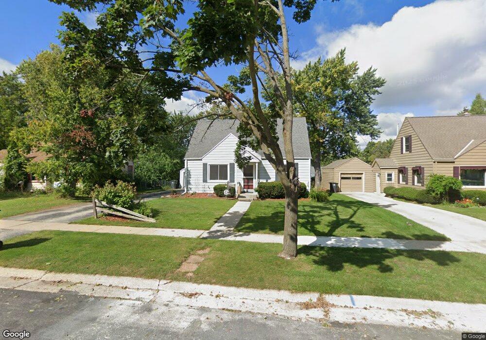
W165N8547 Dardis Ave Menomonee Falls, WI 53051
Estimated Value: $318,485 - $344,000
3
Beds
1
Bath
1,190
Sq Ft
$280/Sq Ft
Est. Value
About This Home
This home is located at W165N8547 Dardis Ave, Menomonee Falls, WI 53051 and is currently estimated at $333,371, approximately $280 per square foot. W165N8547 Dardis Ave is a home located in Waukesha County with nearby schools including Shady Lane Elementary School, North Middle School, and Menomonee Falls High School.
Ownership History
Date
Name
Owned For
Owner Type
Purchase Details
Closed on
May 28, 2010
Sold by
Rush Travis F and Rush Janice M
Bought by
Bader Cindy M
Current Estimated Value
Home Financials for this Owner
Home Financials are based on the most recent Mortgage that was taken out on this home.
Original Mortgage
$173,549
Outstanding Balance
$117,279
Interest Rate
5.14%
Mortgage Type
FHA
Estimated Equity
$216,092
Purchase Details
Closed on
Apr 15, 2005
Sold by
Becht Robert S and Becht Jane L
Bought by
Rush Travis F and Elmergreen Janice M
Home Financials for this Owner
Home Financials are based on the most recent Mortgage that was taken out on this home.
Original Mortgage
$170,900
Interest Rate
5.89%
Mortgage Type
Fannie Mae Freddie Mac
Create a Home Valuation Report for This Property
The Home Valuation Report is an in-depth analysis detailing your home's value as well as a comparison with similar homes in the area
Home Values in the Area
Average Home Value in this Area
Purchase History
| Date | Buyer | Sale Price | Title Company |
|---|---|---|---|
| Bader Cindy M | $173,400 | Priority Title Corporation | |
| Rush Travis F | $179,900 | -- |
Source: Public Records
Mortgage History
| Date | Status | Borrower | Loan Amount |
|---|---|---|---|
| Open | Bader Cindy M | $173,549 | |
| Previous Owner | Rush Travis F | $170,900 |
Source: Public Records
Tax History Compared to Growth
Tax History
| Year | Tax Paid | Tax Assessment Tax Assessment Total Assessment is a certain percentage of the fair market value that is determined by local assessors to be the total taxable value of land and additions on the property. | Land | Improvement |
|---|---|---|---|---|
| 2024 | $2,884 | $258,800 | $91,200 | $167,600 |
| 2023 | $2,764 | $258,800 | $91,200 | $167,600 |
| 2022 | $2,601 | $164,600 | $63,000 | $101,600 |
| 2021 | $2,486 | $164,600 | $63,000 | $101,600 |
| 2020 | $2,633 | $164,600 | $63,000 | $101,600 |
| 2019 | $2,510 | $164,600 | $63,000 | $101,600 |
| 2018 | $2,619 | $164,600 | $63,000 | $101,600 |
| 2017 | $2,728 | $164,600 | $63,000 | $101,600 |
| 2016 | $2,771 | $164,600 | $63,000 | $101,600 |
| 2015 | $2,787 | $164,600 | $63,000 | $101,600 |
| 2014 | $2,977 | $164,600 | $63,000 | $101,600 |
| 2013 | $2,977 | $164,600 | $63,000 | $101,600 |
Source: Public Records
Map
Nearby Homes
- N84W16544 Ann Ave
- N86W16564 Jacobson Dr
- W163N8459 Arthur Ave
- N86W16387 Appleton Ave
- N86W16193 Arthur Ave
- N84W15750 Ridge Rd Unit 204
- N89W16328 Cleveland Ave
- N90W16995 Appleton Ave
- Lt101 Main St
- Lt54 Main St
- Lt8 Main St
- Lt53 Main St
- Lt57 Main St
- Lt13 Main St
- Lt87 Main St
- Lt45 Main St
- Lt38 Main St
- Lt42 Main St
- Lt61 Main St
- Lt80 Main St
- W165N8555 Dardis Ave
- W165N8539 Dardis Ave
- W165N8531 Dardis Ave
- W165N8565 Dardis Ave
- W166N8570 Theodore Ave
- W166N8580 Theodore Ave
- W165N8542 Dardis Ave
- W166N8562 Theodore Ave
- W165N8523 Dardis Ave
- W165N8552 Dardis Ave
- W165N8532 Dardis Ave
- W166N8554 Theodore Ave
- W165N8577 Dardis Ave
- W166N8596 Theodore Ave
- W166N8538 Theodore Ave
- N85W16531 Dardis Place
- W165N8522 Dardis Ave
- W165N8515 Dardis Ave
- W165N8595 Dardis Ave
- N85W16518 Mary Ct