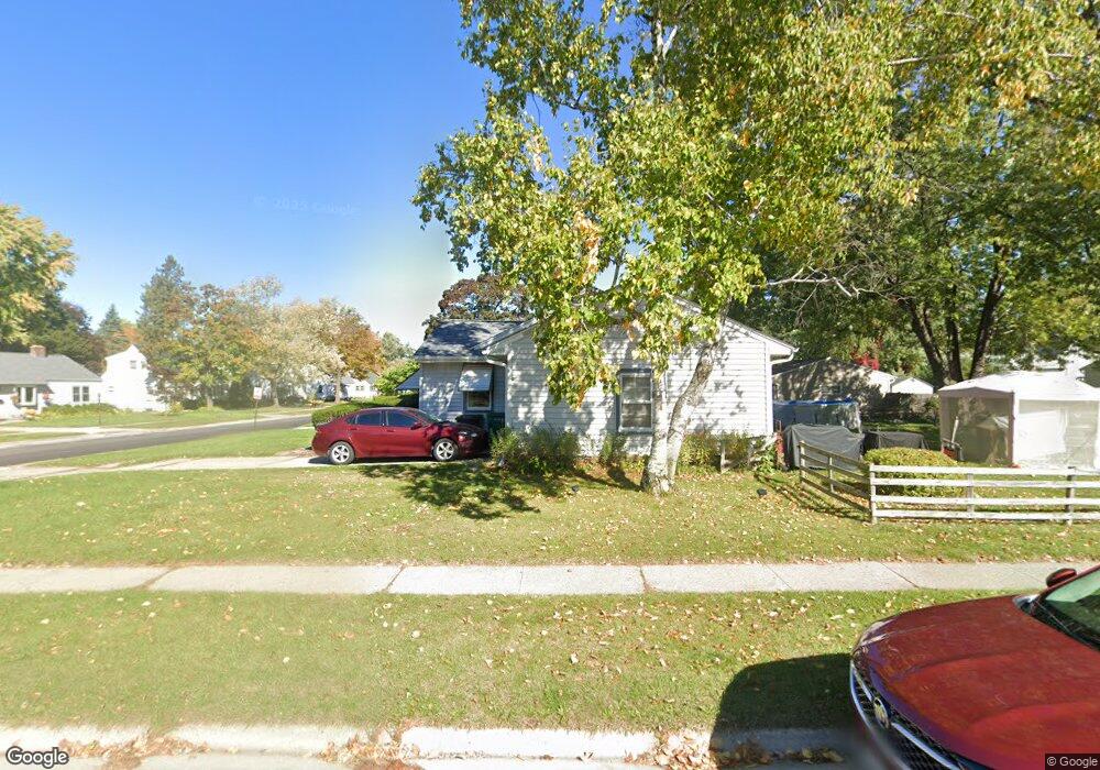
W166N8522 Theodore Ave Menomonee Falls, WI 53051
Estimated Value: $256,000 - $321,000
2
Beds
1
Bath
924
Sq Ft
$307/Sq Ft
Est. Value
About This Home
This home is located at W166N8522 Theodore Ave, Menomonee Falls, WI 53051 and is currently estimated at $283,668, approximately $307 per square foot. W166N8522 Theodore Ave is a home located in Waukesha County with nearby schools including Shady Lane Elementary School, North Middle School, and Menomonee Falls High School.
Ownership History
Date
Name
Owned For
Owner Type
Purchase Details
Closed on
Sep 29, 2006
Sold by
Lachner Fredrick F and Lachner John A
Bought by
Lachner Andrew F
Current Estimated Value
Home Financials for this Owner
Home Financials are based on the most recent Mortgage that was taken out on this home.
Original Mortgage
$163,500
Outstanding Balance
$97,725
Interest Rate
6.49%
Mortgage Type
Purchase Money Mortgage
Estimated Equity
$185,943
Purchase Details
Closed on
Jun 19, 2000
Sold by
Lachner Fredrick F
Bought by
Lachner Fredrick F and Lachner John A
Create a Home Valuation Report for This Property
The Home Valuation Report is an in-depth analysis detailing your home's value as well as a comparison with similar homes in the area
Home Values in the Area
Average Home Value in this Area
Purchase History
| Date | Buyer | Sale Price | Title Company |
|---|---|---|---|
| Lachner Andrew F | $163,500 | Gatewood Title Services | |
| Lachner Fredrick F | -- | -- |
Source: Public Records
Mortgage History
| Date | Status | Borrower | Loan Amount |
|---|---|---|---|
| Open | Lachner Andrew F | $163,500 |
Source: Public Records
Tax History Compared to Growth
Tax History
| Year | Tax Paid | Tax Assessment Tax Assessment Total Assessment is a certain percentage of the fair market value that is determined by local assessors to be the total taxable value of land and additions on the property. | Land | Improvement |
|---|---|---|---|---|
| 2024 | $3,328 | $229,900 | $95,900 | $134,000 |
| 2023 | $3,140 | $229,900 | $95,900 | $134,000 |
| 2022 | $3,308 | $162,400 | $66,300 | $96,100 |
| 2021 | $3,147 | $162,400 | $66,300 | $96,100 |
| 2020 | $3,254 | $162,400 | $66,300 | $96,100 |
| 2019 | $3,309 | $162,400 | $66,300 | $96,100 |
| 2018 | $3,440 | $162,400 | $66,300 | $96,100 |
| 2017 | $3,638 | $162,400 | $66,300 | $96,100 |
| 2016 | $3,673 | $162,400 | $66,300 | $96,100 |
| 2015 | $3,562 | $162,400 | $66,300 | $96,100 |
| 2014 | $2,936 | $162,400 | $66,300 | $96,100 |
| 2013 | $2,936 | $162,400 | $66,300 | $96,100 |
Source: Public Records
Map
Nearby Homes
- N84W16544 Ann Ave
- W163N8459 Arthur Ave
- N86W16564 Jacobson Dr
- N86W16387 Appleton Ave
- N86W16193 Arthur Ave
- N84W15750 Ridge Rd Unit 204
- N89W16328 Cleveland Ave
- N90W16995 Appleton Ave
- W174N8125 Shady Ln Unit 1
- W177N8635 Lynwood Dr
- W166N9108 Grand Ave
- W175N8080 Robin Cir Unit 1
- Lt101 Main St
- Lt54 Main St
- Lt8 Main St
- Lt53 Main St
- Lt57 Main St
- Lt13 Main St
- Lt87 Main St
- Lt45 Main St
- W166N8532 Theodore Ave
- W166N8538 Theodore Ave
- N85W16642 Ann Ave
- N85W16685 Ann Ave
- W165N8515 Dardis Ave
- W165N8523 Dardis Ave
- N84W16651 Ann Ave
- N85W16730 Ann Ave
- W166N8535 Theodore Ave
- W167N8494 Theodore Ave
- W166N8543 Theodore Ave
- N85W16739 Ann Ave
- W165N8531 Dardis Ave
- W166N8554 Theodore Ave
- W166N8479 Dardis Ave
- W166N8551 Theodore Ave
- W166N8562 Theodore Ave
- W167N8499 Theodore Ave
- W167N8484 Theodore Ave
- W165N8539 Dardis Ave