Estimated Value: $213,108 - $354,000
Studio
--
Bath
--
Sq Ft
130,680
Sq Ft Lot
About This Home
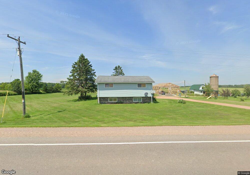
This home is located at W2184 State Highway 98, Loyal, WI 54446 and is currently estimated at $272,527. W2184 State Highway 98 is a home located in Clark County with nearby schools including Loyal Elementary School, Loyal Middle School, and Loyal High School.
Ownership History
Date
Name
Owned For
Owner Type
Purchase Details
Closed on
Jul 18, 2024
Sold by
Jerome E E and Jerome Susan R
Bought by
Murphy Joel R
Current Estimated Value
Purchase Details
Closed on
Jan 9, 2023
Sold by
Murphy Jerome and Murphy Susan Rae
Bought by
Jerome E And Susan R Murphy Irrevocable Trust and Josephson
Purchase Details
Closed on
Oct 13, 2022
Sold by
Murphy Jerome and Murphy Susan Rae
Bought by
Murphy Jerome and Murphy Susan Rae
Create a Home Valuation Report for This Property
The Home Valuation Report is an in-depth analysis detailing your home's value as well as a comparison with similar homes in the area
Purchase History
| Date | Buyer | Sale Price | Title Company |
|---|---|---|---|
| Murphy Joel R | -- | None Listed On Document | |
| Jerome E And Susan R Murphy Irrevocable Trust | -- | None Listed On Document | |
| Murphy Jerome | -- | None Listed On Document |
Source: Public Records
Tax History
| Year | Tax Paid | Tax Assessment Tax Assessment Total Assessment is a certain percentage of the fair market value that is determined by local assessors to be the total taxable value of land and additions on the property. | Land | Improvement |
|---|---|---|---|---|
| 2025 | $2,708 | $137,400 | $10,500 | $126,900 |
| 2024 | $2,640 | $137,400 | $10,500 | $126,900 |
| 2023 | $2,328 | $137,400 | $10,500 | $126,900 |
| 2022 | $2,018 | $137,400 | $10,500 | $126,900 |
| 2021 | $1,975 | $137,400 | $10,500 | $126,900 |
| 2020 | $2,105 | $110,700 | $10,500 | $100,200 |
| 2019 | $2,075 | $110,700 | $10,500 | $100,200 |
| 2018 | $2,019 | $110,700 | $10,500 | $100,200 |
| 2017 | $209 | $110,700 | $10,500 | $100,200 |
| 2016 | $2,029 | $110,700 | $10,500 | $100,200 |
| 2015 | -- | $110,700 | $10,500 | $100,200 |
| 2014 | -- | $110,700 | $10,500 | $100,200 |
| 2013 | -- | $110,700 | $10,500 | $100,200 |
| 2011 | -- | $110,800 | $10,500 | $100,300 |
Source: Public Records
Map
Nearby Homes
- 0 Chickadee Rd Unit 22505635
- 121 N West St
- Lot 4 and 5 Fairhaven Ave
- 815 W Roberts St
- W839 W Rosewood Dr Unit Lot 4
- W887 W Rosewood Dr Unit Lot 1
- 305 W Roberts St
- 0 201 W Dove St Unit 22505694
- 205 W Roberts St
- 203536 Sun Ridge Dr
- 107 E Wendell St
- 203 Kobs St
- 203715 Sun Ridge Dr
- 605 E Maple St
- 803 E Birch St
- 1102 Grant St Unit 1104
- N7066 County Road Y Unit Lot 2
- 101790 Buxton Rd
- OOO County Road F
- 207949 County Road F
- W2183 State Highway 98
- W2262 State Highway 98
- N8860 Catlin Ave
- W2275 State Highway 98
- W2427 State Highway 98
- W1972 State Highway 98
- W2459 State Highway 98
- W2459 State Highway 98
- N8994 Meridian Ave
- N8814 Meridian Ave
- N9004 Meridian Ave
- W1926 State Highway 98
- W1933 State Highway 98
- W2510 State Highway 98
- N8833 Meridian Ave
- Sec 5 Catlin Rd
- N9600 Catlin Rd
- N8781 Meridian Ave
- W2559 State Highway 98
- W2590 State Highway 98
Your Personal Tour Guide
Ask me questions while you tour the home.