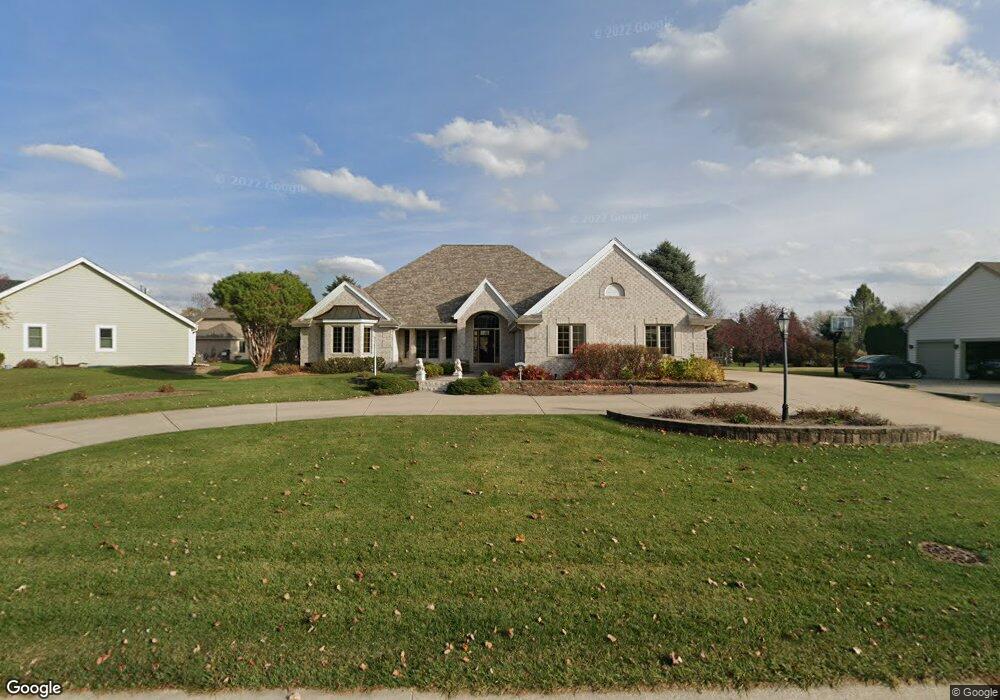
W262N2426 Wilderness Way Pewaukee, WI 53072
Estimated Value: $682,882 - $817,000
--
Bed
--
Bath
--
Sq Ft
0.51
Acres
About This Home
This home is located at W262N2426 Wilderness Way, Pewaukee, WI 53072 and is currently estimated at $732,627. W262N2426 Wilderness Way is a home located in Waukesha County with nearby schools including Pewaukee Lake Elementary School, Asa Clark Middle School, and Pewaukee High School.
Ownership History
Date
Name
Owned For
Owner Type
Purchase Details
Closed on
Jan 17, 1997
Sold by
Fadrow Constance D and Fadrow Theodore
Bought by
Fadrow Constance D
Current Estimated Value
Purchase Details
Closed on
Jan 10, 1997
Sold by
Berendt Roman R
Bought by
Zimmerman Terry E and Zimmerman Mary Jane
Purchase Details
Closed on
Jan 6, 1997
Sold by
Fadrow Constance D
Bought by
Berendt Roman R
Create a Home Valuation Report for This Property
The Home Valuation Report is an in-depth analysis detailing your home's value as well as a comparison with similar homes in the area
Home Values in the Area
Average Home Value in this Area
Purchase History
| Date | Buyer | Sale Price | Title Company |
|---|---|---|---|
| Fadrow Constance D | -- | -- | |
| Zimmerman Terry E | $56,000 | -- | |
| Berendt Roman R | $56,000 | -- |
Source: Public Records
Tax History Compared to Growth
Tax History
| Year | Tax Paid | Tax Assessment Tax Assessment Total Assessment is a certain percentage of the fair market value that is determined by local assessors to be the total taxable value of land and additions on the property. | Land | Improvement |
|---|---|---|---|---|
| 2024 | $5,730 | $497,400 | $156,300 | $341,100 |
| 2023 | $5,704 | $497,400 | $156,300 | $341,100 |
| 2022 | $5,919 | $497,400 | $156,300 | $341,100 |
| 2021 | $5,895 | $497,400 | $156,300 | $341,100 |
| 2020 | $6,913 | $465,500 | $134,400 | $331,100 |
| 2019 | $6,740 | $465,500 | $134,400 | $331,100 |
| 2018 | $6,491 | $465,500 | $134,400 | $331,100 |
| 2017 | $6,596 | $465,500 | $134,400 | $331,100 |
| 2016 | $6,704 | $465,500 | $134,400 | $331,100 |
| 2015 | $6,785 | $465,500 | $134,400 | $331,100 |
| 2014 | $7,412 | $465,500 | $134,400 | $331,100 |
| 2013 | $7,412 | $465,500 | $134,400 | $331,100 |
Source: Public Records
Map
Nearby Homes
- N26W26729 Prospect Ave
- N28W26587 Miami Dr
- W261N2830 Woodburne Ct
- N17W26541 Meadowgrass Cir Unit A
- N28W26972 Woodland Dr
- N16W26500 Meadowgrass Cir Unit B
- 285 Cardinal Ridge Dr Unit 285
- 238 Prospect Ave
- N28W25158 Parkway Ridge Cir Unit B
- W251N2413 Valleyview Cir
- W251N2371 Valleyview Cir
- W251N2437 Valleyview Cir
- W251N2367 Valleyview Cir
- W251N2399 Valleyview Cir
- W251N2459 Valleyview Cir
- W251N2425 Valleyview Cir
- W251N2446 Valleyview Cir
- W251N2385 Valleyview Cir
- W226N1933 Cedar Court Ct Unit 202
- W226N2020 Cedar Lane Ln Unit 1002
- W263N2416 Wilderness Way
- N24W26357 Wilderness Way
- N24W26339 Wilderness Way
- W263N2413 Deer Haven Dr
- W263N2421 Deer Haven Dr
- N24W26321 Wilderness Way
- W263N2390 Wilderness Way
- W264N2464 Wilderness Way
- W263N2405 Deer Haven Dr
- N24W26405 Bucks Island Ct
- W264N2477 Wilderness Way
- W263N2437 Deer Haven Dr
- N25W26342 Wilderness Way
- N25W26420 Bucks Island Ct
- W263N2382 Wilderness Way
- N25W26336 Wilderness Way
- W263N2381 Deer Haven Dr
- N24W26419 Bucks Island Ct
- N25W26324 Wilderness Way
- N25W26473 Whitetail Ct