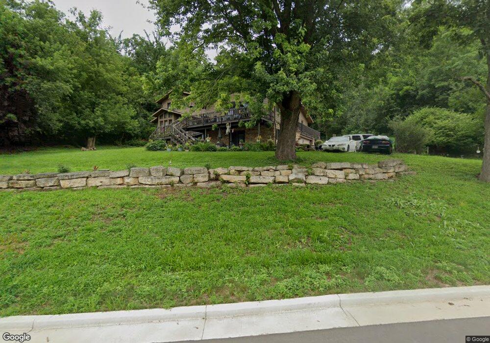
W5330 Boma Rd La Crosse, WI 54601
Estimated Value: $509,000 - $650,000
--
Bed
--
Bath
--
Sq Ft
3.55
Acres
About This Home
This home is located at W5330 Boma Rd, La Crosse, WI 54601 and is currently estimated at $591,045. W5330 Boma Rd is a home located in La Crosse County with nearby schools including State Road Elementary School, Lincoln Middle School, and Central High School.
Ownership History
Date
Name
Owned For
Owner Type
Purchase Details
Closed on
Jul 26, 2024
Sold by
Ragner Keri M and Lowrey Loren J
Bought by
Lowrey Loren J and Ragner Keri M
Current Estimated Value
Purchase Details
Closed on
Aug 24, 2012
Sold by
Young Margaret Susan
Bought by
Ragner Keri M
Home Financials for this Owner
Home Financials are based on the most recent Mortgage that was taken out on this home.
Original Mortgage
$232,000
Interest Rate
3.52%
Mortgage Type
New Conventional
Create a Home Valuation Report for This Property
The Home Valuation Report is an in-depth analysis detailing your home's value as well as a comparison with similar homes in the area
Home Values in the Area
Average Home Value in this Area
Purchase History
| Date | Buyer | Sale Price | Title Company |
|---|---|---|---|
| Lowrey Loren J | -- | Town N Country Title | |
| Ragner Keri M | $290,000 | None Available |
Source: Public Records
Mortgage History
| Date | Status | Borrower | Loan Amount |
|---|---|---|---|
| Previous Owner | Ragner Keri M | $232,000 |
Source: Public Records
Tax History Compared to Growth
Tax History
| Year | Tax Paid | Tax Assessment Tax Assessment Total Assessment is a certain percentage of the fair market value that is determined by local assessors to be the total taxable value of land and additions on the property. | Land | Improvement |
|---|---|---|---|---|
| 2023 | $5,940 | $300,700 | $55,400 | $245,300 |
| 2022 | $5,686 | $300,700 | $55,400 | $245,300 |
| 2021 | $5,828 | $300,700 | $55,400 | $245,300 |
| 2020 | $5,750 | $300,700 | $55,400 | $245,300 |
| 2019 | $5,751 | $300,700 | $55,400 | $245,300 |
| 2018 | $5,622 | $300,700 | $55,400 | $245,300 |
| 2017 | $5,570 | $300,700 | $55,400 | $245,300 |
| 2016 | $5,837 | $300,700 | $55,400 | $245,300 |
| 2015 | $5,732 | $300,700 | $55,400 | $245,300 |
| 2014 | $5,855 | $300,700 | $55,400 | $245,300 |
| 2013 | $6,542 | $309,500 | $50,000 | $259,500 |
Source: Public Records
Map
Nearby Homes
- W5419 Pine Bluff Rd
- W5522 Eagle Point Dr
- W5453 Pine Bluff Rd
- W4844 State Road 33
- N2194 Valley Rd
- W4946 Battlestone Station Rd Unit 23
- W4952 Battlestone Station Rd Unit 25
- W4936 Battlestone Station Rd
- N2031 County Road F -
- N1947 Forest Ridge Dr
- 0 County Road Fa Unit 1932828
- 3421 Greenbriar Ct
- 3055 State Rd
- 3121 Glendale Ave
- N1394 Red Oaks Dr
- 000 Us Highway 14 61 -
- 1965 28th St S
- 3100 Lincoln Ave
- 2802 31st St S
- 2011 Strong Ave