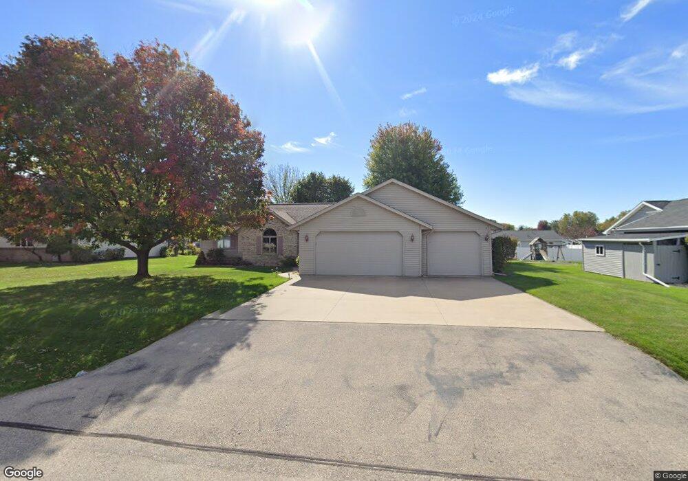
W5577 Amy Ave Appleton, WI 54915
Estimated Value: $373,382 - $410,000
3
Beds
2
Baths
1,568
Sq Ft
$248/Sq Ft
Est. Value
About This Home
This home is located at W5577 Amy Ave, Appleton, WI 54915 and is currently estimated at $389,346, approximately $248 per square foot. W5577 Amy Ave is a home located in Calumet County with nearby schools including Sunrise Elementary School, J.R. Gerritts Middle School, and Mapleview Intermediate School.
Ownership History
Date
Name
Owned For
Owner Type
Purchase Details
Closed on
Jan 24, 2014
Sold by
Fahl Ronald J
Bought by
Billmeyer Tod C
Current Estimated Value
Home Financials for this Owner
Home Financials are based on the most recent Mortgage that was taken out on this home.
Original Mortgage
$5,898
Outstanding Balance
$4,483
Interest Rate
4.49%
Mortgage Type
New Conventional
Estimated Equity
$384,863
Purchase Details
Closed on
Jun 24, 2005
Sold by
Vanlankvelt Jeffrey A and Van Lankvelt Tracy L
Bought by
Fahl Ronald J and Fahl Rebecca M
Home Financials for this Owner
Home Financials are based on the most recent Mortgage that was taken out on this home.
Original Mortgage
$105,000
Interest Rate
5.86%
Mortgage Type
New Conventional
Create a Home Valuation Report for This Property
The Home Valuation Report is an in-depth analysis detailing your home's value as well as a comparison with similar homes in the area
Home Values in the Area
Average Home Value in this Area
Purchase History
| Date | Buyer | Sale Price | Title Company |
|---|---|---|---|
| Billmeyer Tod C | $168,500 | -- | |
| Fahl Ronald J | $178,000 | None Available |
Source: Public Records
Mortgage History
| Date | Status | Borrower | Loan Amount |
|---|---|---|---|
| Open | Billmeyer Tod C | $5,898 | |
| Open | Billmeyer Tod C | $165,447 | |
| Previous Owner | Fahl Ronald J | $105,000 |
Source: Public Records
Tax History
| Year | Tax Paid | Tax Assessment Tax Assessment Total Assessment is a certain percentage of the fair market value that is determined by local assessors to be the total taxable value of land and additions on the property. | Land | Improvement |
|---|---|---|---|---|
| 2024 | $3,774 | $222,600 | $43,800 | $178,800 |
| 2023 | $3,746 | $222,600 | $43,800 | $178,800 |
| 2022 | $3,688 | $222,600 | $43,800 | $178,800 |
| 2021 | $3,582 | $222,600 | $43,800 | $178,800 |
| 2020 | $3,800 | $222,600 | $43,800 | $178,800 |
| 2019 | $3,890 | $222,600 | $43,800 | $178,800 |
| 2018 | $3,771 | $183,700 | $43,800 | $139,900 |
| 2017 | $3,527 | $183,700 | $43,800 | $139,900 |
| 2016 | $3,472 | $183,700 | $43,800 | $139,900 |
| 2015 | $3,544 | $183,700 | $43,800 | $139,900 |
| 2013 | -- | $0 | $0 | $0 |
Source: Public Records
Map
Nearby Homes
- W5479 Hidden Trail Ln
- W5609 Jochmann Dr
- N9427 Dusty Dr
- W2689 Buchanan Rd
- N9639 Crystal Ct
- 253 County Hwy N
- W5598 Hoelzel Way
- N9535 State Park Rd
- N371 Fieldside Ln
- W2512 Buchanan Rd
- W2247 Block Rd
- W2286 Valleywood Ln
- N9337 Rosella Dr
- W5618 Tonys Way
- W5634 Tonys Way
- W5642 Tonys Way
- 592 Cornrow Ln
- W2967 Farmstead Dr
- W5609 Tonys Way
- W5621 Tonys Way
Your Personal Tour Guide
Ask me questions while you tour the home.