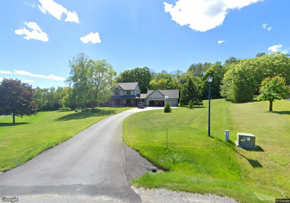
W6271 Hill And Dale Rd Plymouth, WI 53073
Estimated Value: $566,599 - $650,000
4
Beds
3
Baths
2,710
Sq Ft
$224/Sq Ft
Est. Value
About This Home
This home is located at W6271 Hill And Dale Rd, Plymouth, WI 53073 and is currently estimated at $606,150, approximately $223 per square foot. W6271 Hill And Dale Rd is a home located in Sheboygan County with nearby schools including Plymouth High School, St. John the Baptist Catholic School, and St. John Lutheran School.
Ownership History
Date
Name
Owned For
Owner Type
Purchase Details
Closed on
Nov 21, 2024
Sold by
Zank Pamela J
Bought by
Dessloch Jeffrey J
Current Estimated Value
Purchase Details
Closed on
Nov 3, 2016
Sold by
Dessloch Jeffrey J and Dessloch Jeffrey J
Bought by
Dessloch Jeffrey J
Create a Home Valuation Report for This Property
The Home Valuation Report is an in-depth analysis detailing your home's value as well as a comparison with similar homes in the area
Home Values in the Area
Average Home Value in this Area
Purchase History
| Date | Buyer | Sale Price | Title Company |
|---|---|---|---|
| Dessloch Jeffrey J | $215,500 | None Listed On Document | |
| Dessloch Jeffrey J | $215,500 | None Listed On Document | |
| Dessloch Jeffrey J | $149,800 | -- |
Source: Public Records
Tax History Compared to Growth
Tax History
| Year | Tax Paid | Tax Assessment Tax Assessment Total Assessment is a certain percentage of the fair market value that is determined by local assessors to be the total taxable value of land and additions on the property. | Land | Improvement |
|---|---|---|---|---|
| 2024 | $5,675 | $431,000 | $49,000 | $382,000 |
| 2023 | $5,398 | $431,000 | $49,000 | $382,000 |
| 2022 | $4,494 | $431,000 | $49,000 | $382,000 |
| 2021 | $4,447 | $299,500 | $40,800 | $258,700 |
| 2020 | $4,508 | $299,500 | $40,800 | $258,700 |
| 2019 | $4,536 | $299,500 | $40,800 | $258,700 |
| 2018 | $4,309 | $299,500 | $40,800 | $258,700 |
| 2017 | $4,199 | $299,500 | $40,800 | $258,700 |
| 2016 | $4,168 | $299,500 | $40,800 | $258,700 |
| 2015 | $4,231 | $299,500 | $40,800 | $258,700 |
| 2014 | $4,263 | $299,500 | $40,800 | $258,700 |
Source: Public Records
Map
Nearby Homes
- Lt54 Upper Greystone Dr
- Lt55 Upper Greystone Dr
- Lt53 Upper Greystone Dr
- Lt61 Upper Greystone Dr
- Lt65 Upper Greystone Dr
- Lt64 Upper Greystone Dr
- Lt63 Upper Greystone Dr
- Elizabeth Plan at Greystone Settlement
- Springfield Plan at Greystone Settlement
- Simen Plan at Greystone Settlement
- Montrose Manor II Plan at Greystone Settlement
- Vintage Plan at Greystone Settlement
- Barbara Plan at Greystone Settlement
- Sarah Plan at Greystone Settlement
- Elizabeth II Plan at Greystone Settlement
- Simen II Plan at Greystone Settlement
- Isabelle II Plan at Greystone Settlement
- Nottingham Plan at Greystone Settlement
- Nottingham II Plan at Greystone Settlement
- Sarah III Plan at Greystone Settlement
- W6268 Hill And Dale Rd
- W6267 Hill And Dale Rd
- W6260 Hill And Dale Rd
- W6255 Hill And Dale Rd
- W6244 Hill And Dale Rd
- W6241 Hill And Dale Rd
- N5225 Oak Rd
- N5245 Oak Rd
- N5203 Oak Rd
- W6226 Hill And Dale Rd
- W6225 Hill And Dale Rd
- N5297 Oak Rd
- N5267 Oak Rd
- W6202 Hill And Dale Rd
- N5213 Mark Dr
- N5299 Oak Rd
- N5226 Oak Rd
- N5218 Oak Rd
- N5298 Kyle Ct
- N5292 Kyle Ct