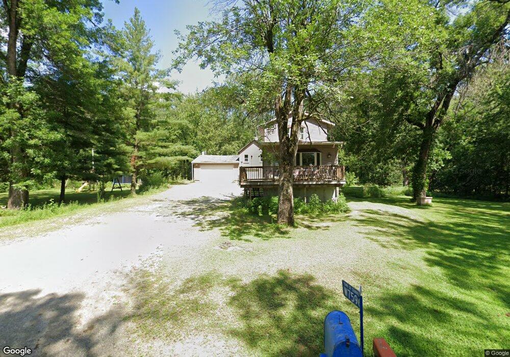
W7596 Blackhawk Island Rd Fort Atkinson, WI 53538
Estimated Value: $372,942
2
Beds
2
Baths
1,140
Sq Ft
$327/Sq Ft
Est. Value
About This Home
This home is located at W7596 Blackhawk Island Rd, Fort Atkinson, WI 53538 and is currently estimated at $372,942, approximately $327 per square foot. W7596 Blackhawk Island Rd is a home located in Jefferson County with nearby schools including Barrie Elementary School, Fort Atkinson Middle School, and Fort Atkinson High School.
Ownership History
Date
Name
Owned For
Owner Type
Purchase Details
Closed on
Jul 23, 2021
Sold by
Hunsicker Nicole T
Bought by
Town Of Sumner
Current Estimated Value
Purchase Details
Closed on
Jan 27, 2017
Sold by
Husnicker Paul D
Bought by
Husnicker Nicole T
Purchase Details
Closed on
May 16, 2008
Sold by
Pesava Larry D and The Estate Of Robert E Pesava
Bought by
Hunsicker Paul D and Hunsicker Nicole T
Home Financials for this Owner
Home Financials are based on the most recent Mortgage that was taken out on this home.
Original Mortgage
$98,000
Interest Rate
5.87%
Mortgage Type
New Conventional
Create a Home Valuation Report for This Property
The Home Valuation Report is an in-depth analysis detailing your home's value as well as a comparison with similar homes in the area
Home Values in the Area
Average Home Value in this Area
Purchase History
| Date | Buyer | Sale Price | Title Company |
|---|---|---|---|
| Town Of Sumner | $290,000 | None Available | |
| Husnicker Nicole T | -- | None Available | |
| Hunsicker Paul D | $122,500 | None Available |
Source: Public Records
Mortgage History
| Date | Status | Borrower | Loan Amount |
|---|---|---|---|
| Previous Owner | Hunsicker Paul D | $98,000 |
Source: Public Records
Tax History Compared to Growth
Tax History
| Year | Tax Paid | Tax Assessment Tax Assessment Total Assessment is a certain percentage of the fair market value that is determined by local assessors to be the total taxable value of land and additions on the property. | Land | Improvement |
|---|---|---|---|---|
| 2024 | -- | $0 | $0 | $0 |
| 2023 | $0 | $0 | $0 | $0 |
| 2022 | $0 | $0 | $0 | $0 |
| 2021 | $3,221 | $168,100 | $34,500 | $133,600 |
| 2020 | $3,141 | $168,100 | $34,500 | $133,600 |
| 2019 | $2,855 | $168,100 | $34,500 | $133,600 |
| 2018 | $2,828 | $168,100 | $34,500 | $133,600 |
| 2017 | $2,618 | $168,100 | $34,500 | $133,600 |
| 2016 | $2,828 | $168,100 | $34,500 | $133,600 |
| 2015 | $2,825 | $168,100 | $34,500 | $133,600 |
| 2014 | $2,903 | $168,100 | $34,500 | $133,600 |
| 2013 | $3,153 | $164,200 | $34,500 | $129,700 |
Source: Public Records
Map
Nearby Homes
- N875 Eagle Ridge Dr
- N878 Eagle Ridge Dr
- N874 Eagle Ridge Dr
- N888 Eagle Ridge Dr
- N884 Eagle Ridge Dr
- N856 Eagle Ridge Dr
- N867 Eagle Ridge Dr
- N862 Eagle Ridge Dr
- N835 Eagle Ridge Dr
- N799 Waubunsee Trail Unit 1
- N557 Cowpath Ln
- Lot #1 Commerce Pkwy
- Lot #7 Commerce Pkwy
- Lot #10 Commerce Pkwy
- Lot #6 Commerce Pkwy
- Lot #9 Commerce Pkwy
- W6368 Briar Ln
- N1609 Pleasant Rd
- W8738 White Crow Rd
- W6272 Apple Ln
- W7604 Blackhawk Island Rd
- W7582 Blackhawk Island Rd
- W7610 Blackhawk Island Rd
- W7578 Blackhawk Island Rd
- W7574 Blackhawk Island Rd
- W7568 Blackhawk Island Rd
- W7638 Blackhawk Island Rd
- W7642 Blackhawk Island Rd
- w 7545 Blackhawk Island Rd
- W7545 Blackhawk Island Rd
- W7650 Blackhawk Island Rd
- W7658 Blackhawk Island Rd
- W7528 Blackhawk Island Rd
- W7516 Blackhawk Island Rd
- W7672 Blackhawk Island Rd
- W7515 Blackhawk Island Rd
- W7511 Blackhawk Island Rd
- W7676 Blackhawk Island Rd
- W7507 Blackhawk Island Rd
- W7680 Blackhawk Island Rd