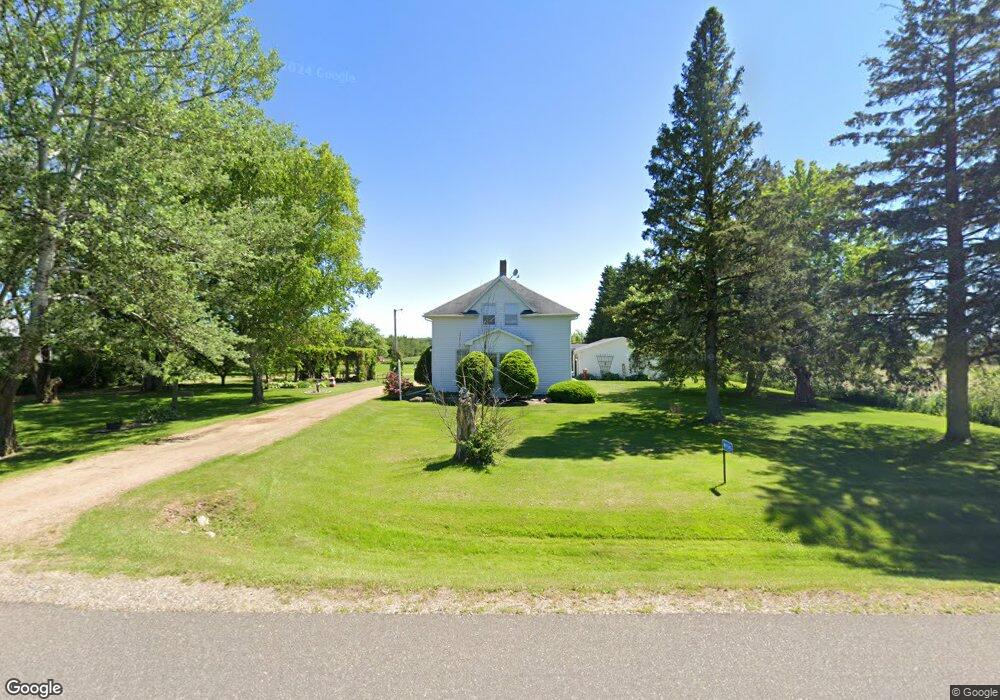
W9345 E 10th Avenue Rd Antigo, WI 54409
Estimated Value: $150,405 - $333,000
--
Bed
--
Bath
--
Sq Ft
6
Acres
About This Home
This home is located at W9345 E 10th Avenue Rd, Antigo, WI 54409 and is currently estimated at $228,601. W9345 E 10th Avenue Rd is a home located in Langlade County with nearby schools including Antigo High School.
Ownership History
Date
Name
Owned For
Owner Type
Purchase Details
Closed on
Oct 31, 2006
Sold by
Saarima Kay
Bought by
Kielcheski David J and Kielcheski Judy K
Current Estimated Value
Home Financials for this Owner
Home Financials are based on the most recent Mortgage that was taken out on this home.
Original Mortgage
$0
Interest Rate
6.47%
Purchase Details
Closed on
Oct 30, 2006
Sold by
Saarima John I and Lyon Susan J
Bought by
Saarima Kay
Home Financials for this Owner
Home Financials are based on the most recent Mortgage that was taken out on this home.
Original Mortgage
$0
Interest Rate
6.47%
Create a Home Valuation Report for This Property
The Home Valuation Report is an in-depth analysis detailing your home's value as well as a comparison with similar homes in the area
Home Values in the Area
Average Home Value in this Area
Purchase History
| Date | Buyer | Sale Price | Title Company |
|---|---|---|---|
| Kielcheski David J | -- | -- | |
| Saarima Kay | -- | Wisconsin Title Inc, 1218 N |
Source: Public Records
Mortgage History
| Date | Status | Borrower | Loan Amount |
|---|---|---|---|
| Closed | Saarima Kay | $0 | |
| Closed | Saarima Kay | $0 |
Source: Public Records
Tax History Compared to Growth
Tax History
| Year | Tax Paid | Tax Assessment Tax Assessment Total Assessment is a certain percentage of the fair market value that is determined by local assessors to be the total taxable value of land and additions on the property. | Land | Improvement |
|---|---|---|---|---|
| 2024 | $1,105 | $75,972 | $17,472 | $58,500 |
| 2023 | $1,182 | $75,944 | $17,444 | $58,500 |
| 2022 | $1,105 | $75,920 | $17,420 | $58,500 |
| 2021 | $1,090 | $75,908 | $17,408 | $58,500 |
| 2020 | $1,180 | $75,900 | $17,400 | $58,500 |
| 2019 | $1,046 | $75,892 | $17,392 | $58,500 |
| 2018 | $1,033 | $75,888 | $17,388 | $58,500 |
| 2017 | $1,114 | $75,884 | $17,384 | $58,500 |
| 2016 | $1,016 | $75,880 | $17,380 | $58,500 |
| 2015 | $1,091 | $75,876 | $17,376 | $58,500 |
| 2014 | $1,060 | $75,876 | $17,376 | $58,500 |
| 2013 | $1,069 | $75,876 | $17,376 | $58,500 |
Source: Public Records
Map
Nearby Homes
- N1622 Cth D
- N2319 Koszarek Rd
- N696 County Rd S
- 524 S Superior St
- 434 Freiburger Ave
- 223 S Superior St
- 313 10th Ave
- 206 10th Ave
- 222 S Superior St
- 116 Watson St
- N10595 U S 45
- 225 9th Ave
- 231 Fischer St
- ON Emma St Unit 1.6 Acres
- 313 Hudson St
- 325 Hudson St
- N2862 Crestwood Rd
- ON 8th Ave
- 230 8th Ave
- 304 8th Ave
- W9341 State Highway 47
- W9337 State Highway 47
- W9337 State Highway 47
- W9405 Forrest Rd
- W9285 State Highway 47
- W9333 State Highway 47
- N841 Cty D
- N880 Christie Rd
- N826 Cty D
- N834 Christie Rd
- N808 Christie Rd
- N805 Christie Rd
- W9201 State Highway 47
- N779 Christie Rd
- W9500 State Highway 47
- W9187 State Highway 47
- W9198 State Highway 47
- N697 County Road D
- W9532 State Highway 47
- N680 Christie Rd