NOT LISTED FOR SALE

XX W County Rd 7393 -- Unit lots 331, 332 Sanders, AZ 86512

Estimated Value: $33,000

19.26 Acres
$1,713 Price per Acre
838,966 Sq Ft Lot

Last Sold April 19, 2024

Last sale price $15,000

Est. 120% increase in value since last sale

Current estimated payment $179/month

75 Days on Market

Highlights

  • Horses Allowed On Property
  • Mountain View
  • Gentle Sloping Lot
  • 19.26 Acre Lot
  • No HOA
  • East or West Exposure

About This Lot

As of April 2024

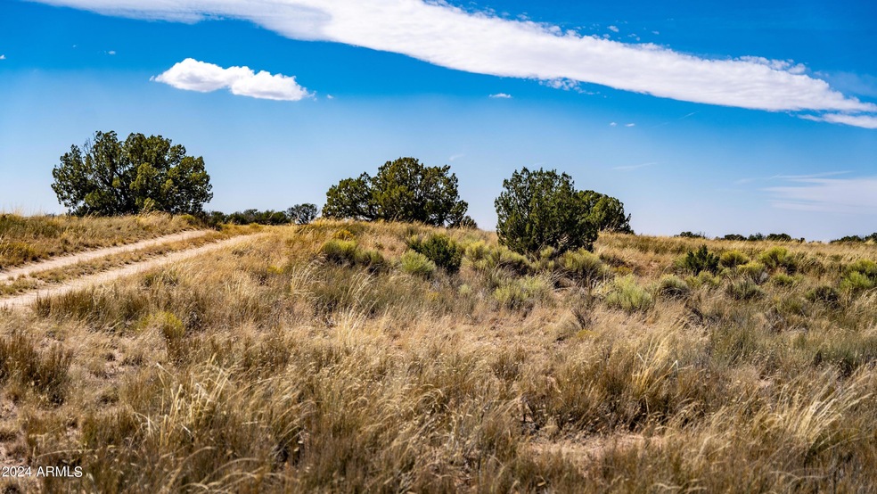
Located less than 20 min from the quaint community of Sanders in NE AZ, this incredible property is easy to reach from I-40. It features high-desert landscapes, wide-open views, varied terrain, and mature juniper and pinon trees. And the wildlife! You can find elk, deer, sheep, antelope, small game, and more. The zoning for the 19+ acre property allows for endless possibilities as there are no time limits for buildings or restrictions on dwelling size. You can build anything for residential purposes, including single-family, mobile, or manufactured homes. You can even use the land for camping, shorter RV adventures, or full-time RV living. Lot is comprised of two parcels which could be sold together or as two separate properties. Principle in owning llc is a real estate agent in AZ

Last Agent to Sell the Property

Jeff Fassett

ProAmerica Real Estate License #BR532733000 Listed on: 01/11/2024

Last Buyer's Agent

Non-MLS Agent

Non-MLS Office

Property Details

Property Type

  • Land

Est. Annual Taxes

  • $38

Lot Details

  • 19.26 Acre Lot
  • East or West Exposure
  • Gentle Sloping Lot
  • 2 Lots in the community
  • Additional Parcels
  • Property is zoned A-Gen

Schools

  • Out Of Maricopa Cnty Elementary And Middle School
  • Out Of Maricopa Cnty High School

Additional Features

  • Mountain Views
  • North or South Exposure
  • Horses Allowed On Property

Community Details

  • No Home Owners Association
  • White Mountain Shadows Subdivision

Listing and Financial Details

  • Tax Lot lots 331, 332
  • Assessor Parcel Number 207-05-146

Property Details

Property Type

Land

Est. Annual Taxes

$38

Lot Details

0

Listing Details

  • Cross Street: US 191 and CR7395
  • Legal Info Range: 31E
  • Property Type: Land
  • Development Status: Raw Land
  • Topography: Gentle Sloping
  • Zoning: A-Gen
  • Tax Year: 2022
  • Directions: US-191 South: 2.8 miles Turn East onto Apache County Rd 7395: 2.2 mi Turn South onto Apache County Rd 7396: 1.3 mi Turn West onto N7393: 0.6 mi Property on the left
  • Horses: Yes
  • Lot Size Acres: 19.26
  • Road Surface Type: Gravel
  • Subdivision Name: WHITE MOUNTAIN SHADOWS
  • View:Mountain View(s): Yes
  • Special Features: None
  • Property Sub Type: LotsLands

Interior Features

  • Possible Use: Single Family, Multi-Family, Agricultural, Mobile/Mgf Hme/RV's, Ranch, Recreational, Rural

Exterior Features

  • Fencing: None
  • Lot Features: East/West Exposure, North/South Exp
  • View: Mountain(s)
  • Disclosures: Seller Prop Disc Stm
  • Other Structures: None

Utilities

  • Electric: None
  • Water Source: None

Condo/Co-op/Association

  • Association: No

Schools

  • Elementary School: Out of Maricopa Cnty
  • High School: Out of Maricopa Cnty
  • Junior High Dist: Sanders Unified District
  • Middle Or Junior School: Out of Maricopa Cnty

Lot Info

  • Lot Size: Unknown
  • Lot Size Sq Ft: 838965.6
  • Number Of Lots: 2
  • Additional Parcels: Yes
  • Parcel #: 207-05-146
  • ResoLotSizeUnits: Acres

Tax Info

  • Tax Annual Amount: 70.5
  • Tax Book Number: 207.00
  • Tax Lot: lots 331, 332
  • Tax Map Number: 5.00

Ownership History

Date Name Owned For Owner Type

Purchase Details

Listed on
Jan 11, 2024
Closed on
Apr 12, 2024
Sold by
Investment Land Alliance Llc
Bought by
Perez Lorenzo O and Perez Brenda Pacheco
Seller's Agent
Jeff Fassett
ProAmerica Real Estate
Buyer's Agent
Non-MLS Agent
Non-MLS Office
List Price
$14,995
Sold Price
$15,000
Premium/Discount to List
$5
0.03%
Views
104
Current Estimated Value
$33,000

Home Financials for this Owner

Home Financials are based on the most recent Mortgage that was taken out on this home.
Estimated Appreciation
$18,000
Avg. Annual Appreciation
55.20%

Purchase Details

Closed on
Nov 20, 2023
Sold by
Clifton D Melby Trust and Barbara C Melby Trust
Bought by
Investment Land Alliance Llc

Purchase Details

Closed on
Feb 22, 2022
Sold by
Melby Clifton D and Melby Barbara C
Bought by
Cliftond Melby Trust
Source: Public Records

Range of Values:

Collateral Analytics

Collateral Analytics Collateral Analytics AVMs (Automated Valuation Model) employ a number of statistical approaches combined with neighborhood-specific comparable selection guarantees the most up-to-date and precise valuations.

Not Available

Collateral Analytics does not have data for the current month. Please view the chart for historical values.

ICE

ICE Mortgage Technology ICE Mortgage Technology’s AVM (Automated Valuation Model) is a state-of-the-art online residential property valuation tool that provides a quick and accurate estimate of the value of almost any home in the U.S.

Not Available

ICE Mortgage Technology does not have data for the current month. Please view the chart for historical values.

First American

First American First American Data & Analytics’ next-generation AVM combines unrivaled data assets with a blended ensemble of valuation models to produce highly accurate, reliable valuations you can trust.

Not Available

First American does not have data for the current month. Please view the chart for historical values.

Quantarium

Quantarium Quantarium’s valuation service, repeatedly proven the industry’s most accurate and comprehensive, is supercharged with a self-learning and auto-tuning AI engine that continually becomes smarter and more accurate as it processes daily inputs from the industry’s leading RE data lake.

Not Available

Quantarium does not have data for the current month. Please view the chart for historical values.

Average Value
Not Available
List Price
Sold Price
Create a Home Valuation Report for This Property
The Home Valuation Report is an in-depth analysis detailing your home's value as well as a comparison with similar homes in the area

Home Values in the Area

Source: Public Records

Average Home Value in this Area


Source: Public Records

Purchase History

Date Buyer Sale Price Title Company
Perez Lorenzo O $18,500 --
Investment Land Alliance Llc $6,850 Pioneer Title
Cliftond Melby Trust -- Charles A Adams Pc
Source: Public Records

Property History

Date Event Price Change Sq Ft Price
04/19/2024 04/19/24 Sold $15,000 0.0% --
03/27/2024 03/27/24 Pending -- -- --
01/11/2024 01/11/24 For Sale $14,995 -- --
Source: Arizona Regional Multiple Listing Service (ARMLS)

Tax History Compared to Growth

Source: Public Records

Tax History

Year Tax Paid Tax Assessment Tax Assessment Total Assessment is a certain percentage of the fair market value that is determined by local assessors to be the total taxable value of land and additions on the property. Land Improvement
2026 $38 $439 -- --
2025 $35 $418 -- --
2024 $35 $398 $0 $0
2023 $35 $379 $0 $0
2022 $34 $361 $0 $0
2021 $35 $361 $0 $0
2020 $36 $361 $0 $0
2019 $35 $361 $0 $0
2018 $44 $455 $0 $0
2017 $90 $916 $0 $0
2016 $93 $997 $0 $0
2015 $87 $997 $0 $0
2014 $87 $997 $997 $0
Source: Public Records

Agents Affiliated with this Home

  • Section Image
See All Agents

Map

Source: Arizona Regional Multiple Listing Service (ARMLS)

MLS Number: 6648876

Arizona Regional Multiple Listing Service (ARMLS)

APN: 207-05-146