$270,865Average Value$154Average Price per Sq Ft18Homes For Sale
Just outside downtown Massillon
Suburban-style homes and nearly-rural open spaces sandwich between commerce and industry in Southeast Massillon, a neighborhood adjacent to the town’s core and west of Canton, Ohio. But it’s not all work and home life. Golf courses, ballparks, and access to a renowned trail combine with a deeper-than-typical connection to football to define the neighborhood of about 1,110 homes.
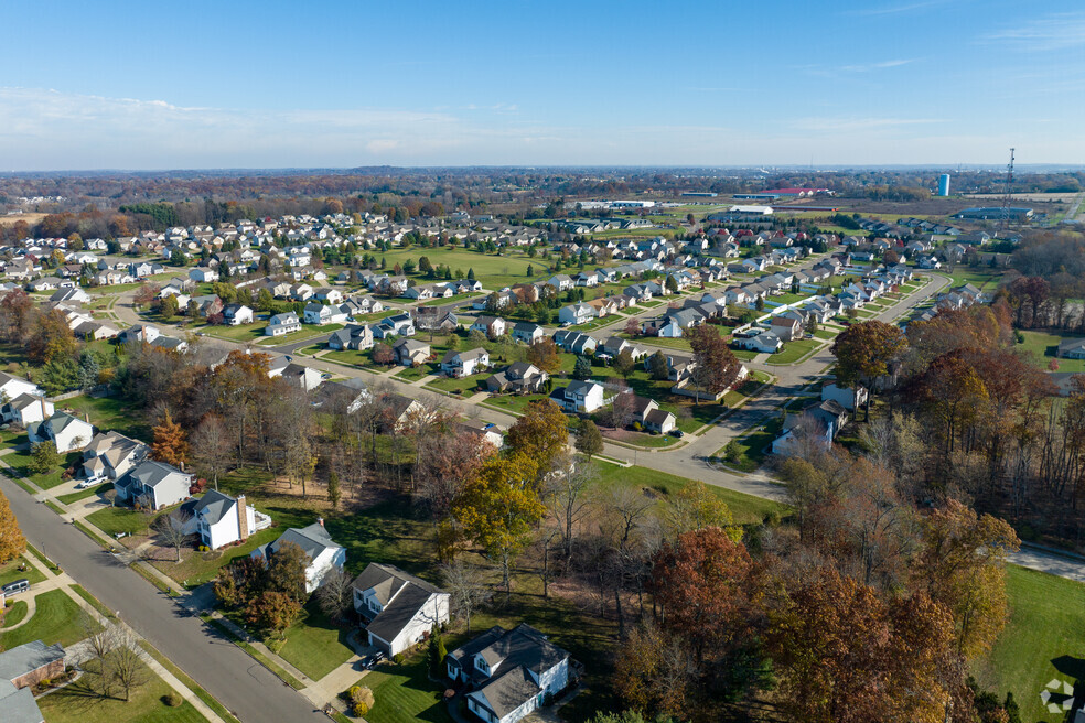
A sparse suburban enclave
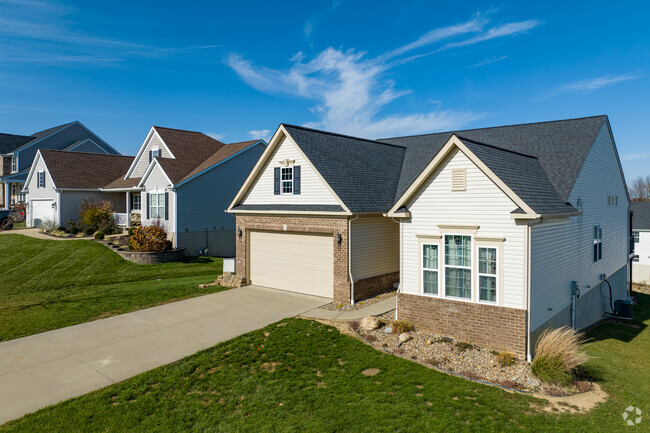
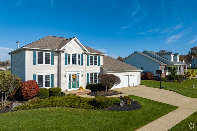
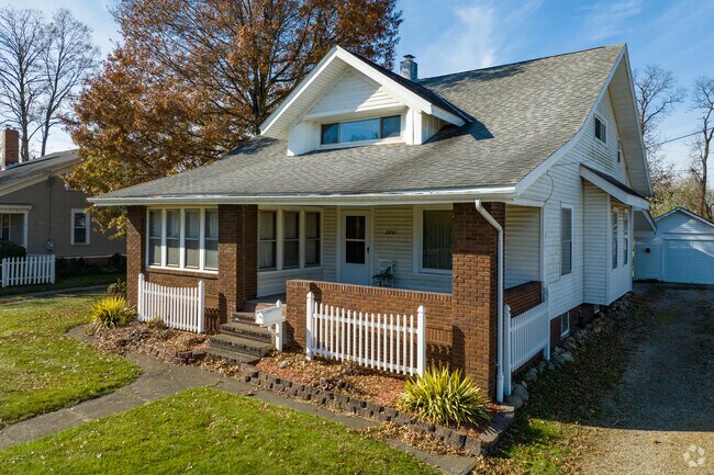
Homes are clustered in the center half, ranging from properties of about a quarter acre to more than a full acre. New traditional homes with colonial influences and older, updated ranch-style homes dot broad streets with narrow sidewalks, especially west of Richville Drive Southwest. In areas with larger lots, though, sidewalks are not as common. Most homes sell for $100,000 to $300,000, whereas homes constructed in 2010 or later range from $300,000 to $550,000.
A fair number of homes in Southeast Massillon offer three car garages.
Homes in Southeast Massillon have unique features and often showcase welcoming front porches.
1/2
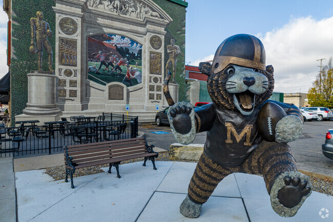
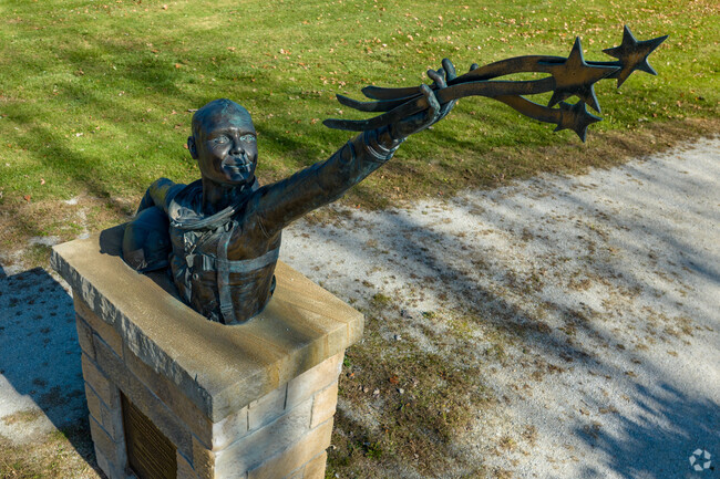
Community-wide support for the Massillon Tigers
The Massillon City School District serves the neighborhood. Students can attend Franklin Elementary School, Massillon Intermediate School, Massillon Junior High and Washington High School, all of which received a B-minus from Niche. The Washington High football team’s influence and the legacy of its more-than-century-old rivalry with nearby McKinley High goes beyond the gridiron and the high schools. “People are super passionate about the football team,” says Tyler Kuhns, a Realtor with Stewardship Realty, LLC, who grew up 20 miles from the neighborhood.
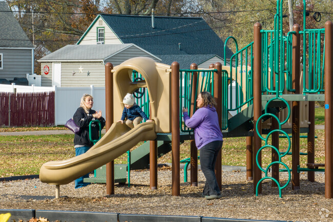
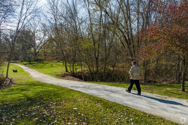
Afternoon walks and tee times
Located on Warmington Road Southwest is John Glenn Grove Park, which includes a trailhead for Congressman Ralph Regula Towpath Trail, a 110-mile-long Ohio & Erie Canal path popular with hikers and cyclists. Two miles northeast is Arthur Genshaft Memorial Park, which features recently updated ballparks reserved for softball leagues. The park also has a concession stand and pavilion. The Legends of Massillon, a 27-hole resort-style golf course and clubhouse, is also home to an indoor and outdoor event venue for weddings and parties. Public access to the golf course is available but limited. Downtown Massillon, just north of the neighborhood, hosts the Paul Brown Museum, which honors the former Washington High coach who went on to a Pro Football Hall of Fame career coaching the Cleveland Browns and Cincinnati Bengals. Located on Lincoln Way East, the Massillon Museum features several art exhibits while providing interactive and educational events all year. Nearby, the Massillon Public Library has regular book recommendations and a full calendar of programs for residents to enjoy.
Legends of Massillon is a fun and challenging 27-hole course with over 80 sand bunkers.
All different walks of life come together in Southeast Massillon.
1/2
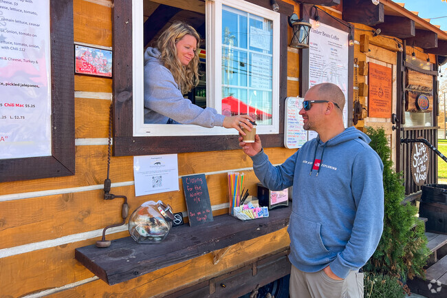
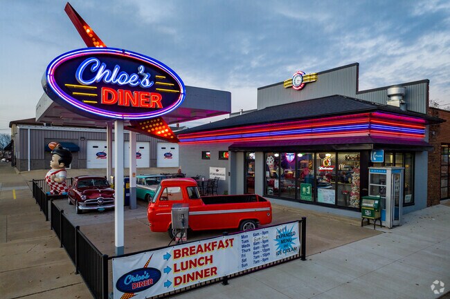
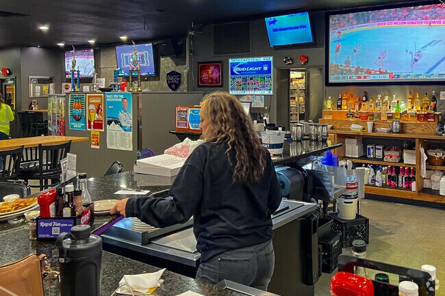
Local dives open from early morning to late night
Lowe’s Home Improvement, Menards, Wal-mart Supercenter, Aldi, Starbucks and a variety of national chain fast-food restaurants operate around the cloverleaf confluence of U.S. highways 30 and 62 and Ohio Route 21 in the southwest corner of the neighborhood. It’s about a 7-mile drive from the farthest portion of the neighborhood. Not far away, on Erie Street South is Erie Street Pub, a popular sports tavern serving traditional pub grub. Just outside Southeast Massillon, about 1 mile north of the neighborhood, is Cameo Grille, serving burgers and classic American fare for more than 70 years.
Chloe's Diner takes customers back in time to the 1950's.
Over 30 plasma TVs and 5 huge projection screens playing sports at the Erie Pub.
1/2
Getting around Southeast Massillon
The Stark Area Regional Transit Authority has one set route that takes passengers from the neighborhood into the city and offers Proline ADA Paratransit, a more accessible public transit for those unable to use the fixed routes. Residents can take U.S. Route 62 to get into the city or hop on U.S. Route 30 for 10 miles to reach Canton. For longer-distance travel, the Akron-Canton Airport is about 14 miles north.
GreatSchools:
The GreatSchools Rating helps parents compare schools within a state based on a variety of school quality indicators and provides a helpful picture of how effectively each school serves all of its students. Ratings are on a scale of 1 (below average) to 10 (above average) and can include test scores, college readiness, academic progress, advanced courses, equity, discipline and attendance data. We also advise parents to visit schools, consider other information on school performance and programs, and consider family needs as part of the school selection process.
View GreatSchools Rating Methodology
Are you familiar with the Southeast Massillon neighborhood?
to let others know what life in this neighborhood is like.
Crime and Safety
1 - Low Crime, 10 - High Crime
Southeast Massillon
US
Homicide
4
4
Sexual Assault
3
4
Assault with Weapon
4
4
Robbery
4
4
Burglary
4
4
Motor Vehicle Theft
4
4
Larceny
3
4
Crime Score
4
4
Source: WhatIsMyCrimeRisk.com
Southeast Massillon Demographics and Home Trends
On average, homes in Southeast Massillon, Massillon sell after 56 days on the market compared to the national average of 55 days. The median sale price for homes in Southeast Massillon, Massillon over the last 12 months is $294,500, up 3% from the median home sale price over the previous 12 months.
Welcome to 2735 Doral Circle SE in Massillon! This well-maintained home offers comfortable living in a desirable neighborhood with convenient access to shopping, dining, major roadways, and the Legends of Massillon Golf Course. Inside, you'll find a spacious and functional layout filled with natural light. Beautiful hardwood floors in the main living area create a warm and inviting space for
Rare investment opportunity in Perry Township! Situated on a spacious one-acre lot, this income-producing property includes two fully rented homes offering immediate cash flow. The up/down duplex features two well-maintained two-bedroom, one-bath units, while the separate ranch home offers three bedrooms and one full bath—providing a strong and versatile rental mix. Both properties have been
This buildable .31 acre lot is partially wooded and is on a dead end street and is located in the Perry Local School District. Lot is level and has 65' of frontage and is 383' deep. Public water and public sewer. Directions: Erie St. to east on Forest Ave. SE. to south on Candell St. SE.
This buildable .53 acre partially wooded lot is on a dead end street and is located in the Perry Local School District. Lot is level and has 60' of frontage and is 383' deep. Public water and public sewer. Directions: Erie St. to east on Forest Ave. SE. to south on Candell St. SE.
Amazing opportunity to build your new home in this quiet Perry Township location. Quiet neighborhood that is great for walking and features beautiful newer homes. More than a third of an acre and includes all underground public utilities including water, sewer, natural gas and electric. Nice paved streets with storm sewer. Perry schools. Slightly sloping lot that can accommodate a walkout
Rare income-producing opportunity on over 2 acres in a convenient Massillon location. The highlight of this unique property is a spacious, remodeled barndominium offering exceptional rental or owner-occupant potential. Featuring soaring ceilings and versatile living space, the open-concept main level includes a large living area with a wood-burning stove, an eat-in kitchen with custom details and
Simplify your lifestyle in Augusta Lakes. Where golf course views and convenience meet in this one of a kind opportunity. Build your dream home with award winning builder, Smith Homes. This dream villa has a HOA that includes neighborhood and scenic views of The Legends Golf Course. Schedule an appointment today to create your forever home or for a list of other available lots and coming
Fabulous opportunity to build your dream home with your approved BIA Builder in Augusta Lakes. $59,900 in Perry Local Schools. Located near all the conveniences and Legends Gold Course. Public utilities. Lovely walkable neighborhood. ***This is a Single Family lot and can be any builder approved by the The Building Industry Association of Stark County.***
This buildable .27 acre partially wooded lot is on a dead end street and is located in the Perry Local School District. Lot is level and has 65' of frontage and is 180' deep. Public water and public sewer. Directions: Erie St. to east on Forest Ave. SE. to south on Candell St. SE.
This buildable .57 acre partially wood lot is on a dead end street and is located in the Perry Local School District. Lot is level and has 65' of frontage and is 383' deep. Public water and public sewer. Directions: Erie St. to east on Forest Ave. SE. to south on Candell St. SE.
Fantastic opportunity to live on the St Andrews Golf Course. Far enough back from getting hit by flying clubs or balls (if you golf like I do ;) but wonderful view at rear of home. Greet your guests in welcoming foyer before you take them into the convenient first floor office to meet. Create amazing meals in your kitchen complete with breakfast bar, granite countertops, stainless steel
This buildable .57 acre partially wooded lot is on a dead end street and is located in the Perry Local School District. Lot is level and has 65' of frontage and is 383' deep. Public water and public sewer. Directions: Erie St. to east on Forest Ave. SE. to south on Candell St. SE.
This garden style apartment has an open concept layout featuring a spacious living room, kitchen and dining area. The kitchen is fully applianced and is equipped with upper and lower cabinets and an abundance of counter space. This two bedroom apartment has a spacious master suite with a private bath and walk-in closet. The second bedroom would be great for guests and/or a home office. The
Local Logic measures the walkability, access to public transit and bikeability of any address. CAP Index provides objective, accurate, and consistent data to help measure, compare, and mitigate crime risks.
Disclaimer: Certain information contained herein is derived from information provided by parties other than Homes.com. Our sources include: Accuweather, Public Records and Neustar. All information provided is deemed reliable, but is not guaranteed to be accurate and should be independently verified.