
0 Bacon St Jermyn, PA 18433
Estimated payment $333/month
Highlights
- 4.56 Acre Lot
- No HOA
- 2-minute walk to Rippy Callahan Recreational Park
- Wooded Lot
About This Lot
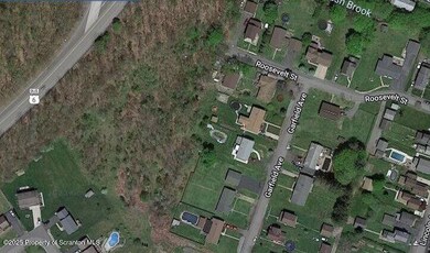
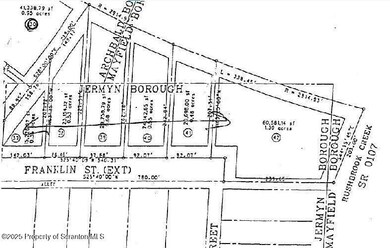
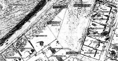
Currently there are no utilities within the vacant land. Utilities are available in the borough to be brought to property.Property sits between Route 6, Franklin and Roosevelt Streets within 3 boroughs. There are 3 parcels being sold together totaling 4.56 acres.
Property Details
Property Type
- Land
Est. Annual Taxes
- $917
Lot Details
- 4.56 Acre Lot
- Irregular Lot
- Wooded Lot
- 3 Lots in the community
- Pin 07312030012 Deed 201518314, Pin 073020200010, Deed 202409502Pin 07304040001 Deed 201518314
- Property is zoned R-1, R-2, C-2
Utilities
- Not Connected to Water Source
- Sewer Not Available
Community Details
- No Home Owners Association
Listing and Financial Details
- Assessor Parcel Number 07312030012
- $4,100 per year additional tax assessments
Map
Home Values in the Area
Average Home Value in this Area
Property History
| Date | Event | Price | List to Sale | Price per Sq Ft |
|---|---|---|---|---|
| 11/25/2025 11/25/25 | Pending | -- | -- | -- |
| 10/26/2025 10/26/25 | Off Market | $49,000 | -- | -- |
| 04/22/2025 04/22/25 | For Sale | $49,000 | -- | -- |
Source: Greater Scranton Board of REALTORS®
MLS Number: GSBSC251802
Disclaimer: Certain information contained herein is derived from information provided by parties other than Homes.com. All information provided is deemed reliable, but is not guaranteed to be accurate and should be independently verified.
![]() Information provided by the Greater Scranton Board of REALTORS® MLS. Information is for consumer’s personal noncommercial use, and may not be used for any purpose other than identifying properties which consumers may be interested in purchasing. Consult the specific municipality for permitted Zoning uses.
Information provided by the Greater Scranton Board of REALTORS® MLS. Information is for consumer’s personal noncommercial use, and may not be used for any purpose other than identifying properties which consumers may be interested in purchasing. Consult the specific municipality for permitted Zoning uses.
- 441 Madison Ave
- 603 Lincoln Ave
- 440 Washington Ave
- 0 Scranton Carbondale Hwy
- 0 Chestnut St
- 322 Shadow Wood Cir Unit U13
- 192 Shadow Wood Cir
- 333 Shadow Wood Cir
- 233 Shadow Wood Cir
- 118-120 Madison Ave
- 880 Scranton - Carbondale
- 815 Oak St
- 820 Oak St
- 590 N Main St
- 426 Wildcat (Rt 247) Rd
- 723 Chestnut St
- 0 Skyline Dr
- 0 Forest Ln
- 369 Upper Powderly St
- 0 Ledgewood Dr
