


0 I-49 None Natchitoches, LA 71457
Estimated payment $5,597/month
About This Lot
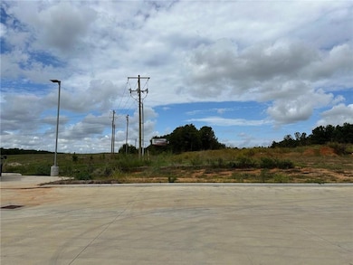
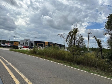
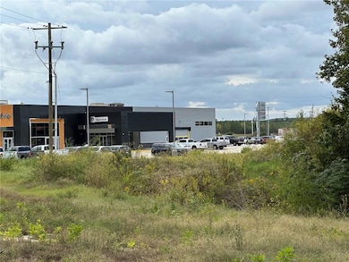
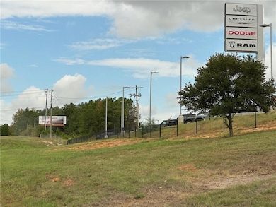
23+ commercial acres with 589 feet road frontage on Hwy LA-504. Prime location East of Natchitoches, at I-49 & University Parkway exit. Neighboring business is newly built Hebert Jeep Chrysler Dodge Ram. Perfect location for retail, restaurants, offices & more. Inside city limits & zoned Commercial B3. Utilities at street include SWEPCO electric, Atmos gas, city water & sewer. Income producing billboard at West property line visible from I-49 - brings in $3,000 a year. Minerals will transfer to the buyer. This property is not in a flood zone. Can be purchased with 2 neighboring commercial lots totaling 5.24 acres - increasing road frontage another 557 feet.
Property Details
Property Type
- Land
Est. Annual Taxes
- $10,182
Lot Details
- 23.83 Acre Lot
- Subdivision Possible
- Property is zoned B3
Location
- Outside City Limits
Listing and Financial Details
- Assessor Parcel Number 0011340700
Map
Home Values in the Area
Average Home Value in this Area
Tax History
| Year | Tax Paid | Tax Assessment Tax Assessment Total Assessment is a certain percentage of the fair market value that is determined by local assessors to be the total taxable value of land and additions on the property. | Land | Improvement |
|---|---|---|---|---|
| 2024 | $10,182 | $98,800 | $98,800 | $0 |
| 2023 | $9,998 | $95,000 | $95,000 | $0 |
| 2022 | $9,998 | $95,000 | $95,000 | $0 |
| 2021 | $10,102 | $95,000 | $95,000 | $0 |
| 2020 | $11,067 | $102,000 | $102,000 | $0 |
| 2019 | $10,921 | $100,000 | $100,000 | $0 |
| 2018 | $44 | $380 | $380 | $0 |
| 2017 | $40 | $380 | $380 | $0 |
| 2015 | $35 | $310 | $310 | $0 |
| 2014 | $36 | $310 | $310 | $0 |
| 2013 | $30 | $310 | $310 | $0 |
Property History
| Date | Event | Price | Change | Sq Ft Price |
|---|---|---|---|---|
| 04/02/2025 04/02/25 | Price Changed | $849,900 | -11.5% | -- |
| 01/16/2025 01/16/25 | For Sale | $960,000 | -- | -- |
Purchase History
| Date | Type | Sale Price | Title Company |
|---|---|---|---|
| Grant Deed | $525,000 | -- | |
| Grant Deed | $1,350,100 | -- |
Source: Greater Central Louisiana REALTORS® Association
MLS Number: 2483375
APN: 0011340700
Disclaimer: Certain information contained herein is derived from information provided by parties other than Homes.com. All information provided is deemed reliable, but is not guaranteed to be accurate and should be independently verified.
![]() IDX information is provided exclusively for personal, non-commercial use, and may not be used for any purpose other than to identify prospective properties consumers may be interested in purchasing. Information is deemed reliable but not guaranteed.
IDX information is provided exclusively for personal, non-commercial use, and may not be used for any purpose other than to identify prospective properties consumers may be interested in purchasing. Information is deemed reliable but not guaranteed.
- 1670 Highway 504
- 5409 University Pkwy
- 172 Haley Cir
- 192 Mr Ed Ln
- 5964 Highway 6
- Tract 2 Deer Creek Rd
- 820 Highway 504
- 168 Moss Hill Terrace Rd
- 4340 Hwy 3278 None
- 282 Par Road 536
- 4261 University Pkwy
- 000 Hicks
- 110 Eastin Cir
- 105 Madalyn Dr
- tbd Route 6
- 111 Madalyn Dr
- 114 Eastin Cir
- 160 Sandra St
- TBD Sandra St
- 212 Sandra St
