
Seller's Agent in 2022
Craig Marcum
Long & Foster
(443) 875-8502
1 in this area
30 Total Sales

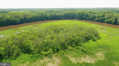
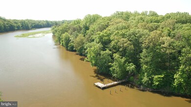
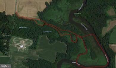
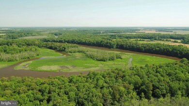
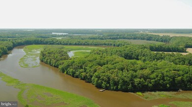
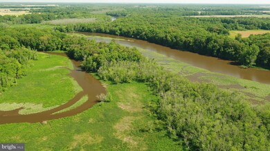
Priced to sell. Owner is tired of endless showings! Welcome to Highfield Acres and Eagles Watch! SRA Approved for a building lot. Bounded on one side by a fresh water, hard bottom creek, which merges with the brackish water of the Tuckahoe for a large portion of the remaining boundary. This is an amazing property! Hunters, outdoor, and wildlife enthusiasts; if you are looking for a one of a kind AMAZING property on which to create the lifestyle many only dream of, read on! First time listed for sale in over 20 years, this 77 acre property is great for hiking, camping, fishing, hunting, photography, and farming on your own private park with approximately 3/4 to 1 mile of frontage on Highfield Creek and Tuckahoe River. Located in Cordova MD, about 3 miles off Rt 404, the property is about 9 miles from Easton , 18 miles from St. Michaels, and 38 miles from Annapolis. 10 minutes to commercial Easton airport. Enjoy the peaceful Eastern Shore lifestyle, while close enough to frequent the dining, shopping, and recreational activities offered in Denton, Easton, Saint Michaels, Kent Island, and Annapolis in just a short pleasant ride. Several miles to the local public boat launch. The historic Wayman Wharf site is just across the creek. The property consists of about 30 acres of beautiful land, surrounded in areas by 47 acres of wildlife filled marsh land. Highfield Acres refers to the upper portion of the property, consisting of a beautiful level site, with a nice open field, surrounded by woods on 3 sides, on land which gently slopes to fresh water, hard bottom, Highfield Creek. The boundary of the upper portion of the property extends to the center of Highfield Creek on the right side as the creek peacefully meanders its way to Tuckahoe River. The boundary on the left side in areas extends 17 feet from the center of Mill Ridge Road, as the owner of this property is the owner of Mill Ridge Road. At the property entrance, the cedar trees to the left of the road are the boundary. The road is maintained through deeded agreements, by the owners of the other 6 lots on Mill Ridge Road. The community pier is also owned by the owner of this property, and is also maintained through deeded agreements by the other six home owners in the community. (The current owner has often joined in for work done, but was not required to). The pier is great for gatherings, a base for your fishing or pontoon boat, or swimming platform. Eagles Watch refers to the lower portion of the property accessed through a narrow passage between the lot 6 home and Highfield Creek. All lower land, including the joining marsh, visible at low tide and bounded by the lot 6 home, Highfield Creek, and Tuckaho River, is owned by the owner of this property. This portion of the property notably also contains some hemlock trees, which are unusual for the area. Hike the trails created by the current owner over the past 20 years, or make more trails, to access your own private camping areas, fishing holes, blinds or stands, or just rest in the pristine wooded areas, while watching and listening to the abundant eagles, geese, ducks, deer, turkeys and other Eastern Shore wildlife. The property is pristine. When the original farm was purchased and subdivided many years ago, a sewage reserve area was approved by the county for a building site on the upper end of the 77 acre parcel. The current owner never pursued the thought of building, wishing to simply enjoy the land only. A call to the county is recommended in order to learn the best way to move forward to build your home. To the best of the owners knowledge, there are no restrictions on the removal of timber. This is an amazing opportunity.
Last Agent to Sell the Property
(443) 875-8502 craig.marcum@lnf.com Long & Foster Real Estate, Inc. License #644793 Listed on: 05/20/2021
| Date | Event | Price | List to Sale | Price per Sq Ft |
|---|---|---|---|---|
| 11/14/2022 11/14/22 | Sold | $330,000 | +1.5% | -- |
| 10/04/2022 10/04/22 | Pending | -- | -- | -- |
| 09/29/2022 09/29/22 | Price Changed | $325,000 | -23.5% | -- |
| 11/10/2021 11/10/21 | For Sale | $425,000 | +28.8% | -- |
| 11/09/2021 11/09/21 | Off Market | $330,000 | -- | -- |
| 07/28/2021 07/28/21 | Price Changed | $425,000 | -10.5% | -- |
| 05/20/2021 05/20/21 | For Sale | $475,000 | -- | -- |
Seller's Agent in 2022
Craig Marcum
Long & Foster
(443) 875-8502
1 in this area
30 Total Sales
Buyer's Agent in 2022
Joyce Wallace
Coldwell Banker (NRT-Southeast-MidAtlantic)
(410) 310-0800
3 in this area
14 Total Sales
Source: Bright MLS
MLS Number: MDTA140202
Disclaimer: Certain information contained herein is derived from information provided by parties other than Homes.com. All information provided is deemed reliable, but is not guaranteed to be accurate and should be independently verified.
![]() The data relating to real estate for sale on this website appears in part through the BRIGHT Internet Data Exchange program, a voluntary cooperative exchange of property listing data between licensed real estate brokerage firms, and is provided by BRIGHT through a licensing agreement.
The data relating to real estate for sale on this website appears in part through the BRIGHT Internet Data Exchange program, a voluntary cooperative exchange of property listing data between licensed real estate brokerage firms, and is provided by BRIGHT through a licensing agreement.
Listing information is from various brokers who participate in the Bright MLS IDX program and not all listings may be visible on the site.
The property information being provided on or through the website is for the personal, non-commercial use of consumers and such information may not be used for any purpose other than to identify prospective properties consumers may be interested in purchasing.
Some properties which appear for sale on the website may no longer be available because they are for instance, under contract, sold or are no longer being offered for sale.
Property information displayed is deemed reliable but is not guaranteed.
Copyright 2025 Bright MLS, Inc.