$325,000
PENDING

0 Pheasant Dr Unit 109561 Central, UT 84722

Central Neighborhood

Estimated payment $1,908/month

Total Views 33,306
1.28 Acres
$253,906 Price per Acre
55,757 Sq Ft Lot

Highlights

  • 1.28 Acre Lot
  • No HOA
  • Level Lot
  • Pine Trees

About This Lot

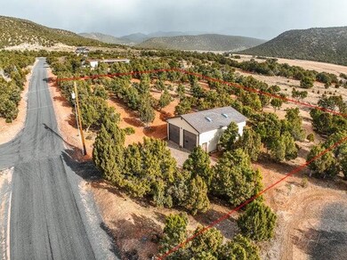
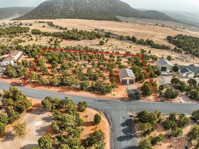
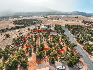
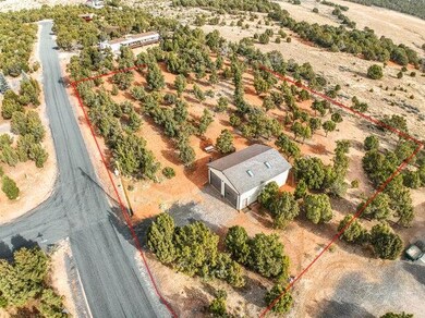
One of BEST locations in Central! Backs to 1000 + acre private Saucer 5 Ranch with unobstructed views! Paved road for easy access. 30 x 40 stick built garage with two 12 ft roll up doors. plumbing (toilet) and all utilities connected. Two FULL RV hookups. Build out a studio apt or use as garage/shop. Plenty of choice locations to build your dream home. Enjoy the quiet, dark starry nights and only 25 miles to St George.

Listing Agent

MARY JO HALES

COLDWELL BANKER PREMIER REALTY License #5487792-SA00

COLDWELL BANKER PREMIER REALTY

Property Details

Property Type

  • Land

Est. Annual Taxes

  • $1,162

Year Built

  • 2009

Lot Details

  • 1.28 Acre Lot
  • Level Lot
  • Pine Trees
  • Property is zoned RD-0.5

Community Details

  • No Home Owners Association
  • Dixie Deer Estates Subdivision

Listing and Financial Details

  • Tax Lot 53B
  • Assessor Parcel Number DDE-2-53-B

Property Details

Property Type

Land

Est. Annual Taxes

$1,162

Year Built

2009

Lot Details

0

Listing Details

  • Directions: Hwy 18 to Central, Turn right onto Pine Valley Hwy, left onto Mountain View Dr, right onto Cottontail Rd, go to end of road, property is straight ahead on Pheasant Drive
  • Prop. Type: Land
  • Reso Property Sub Type: Lot
  • Road Surface Type: Paved, Year Round Access, County Maintained, Public Access
  • Subdivision Name: Dixie Deer Estates
  • Master Plan Zoning: RD-0.5
  • Terrain Flat: Yes
  • Terrain Gradual Slope: Yes
  • VegetationCrops:Trees-Pine: Yes
  • Water Source Culinary-City: Yes
  • Utilities Electric-Connected: Yes
  • Special Features: None
  • Property Sub Type: LotsLands
  • Year Built (Public Record): 2009

Exterior Features

  • Acres: 1.28

Condo/Co-op/Association

  • Senior Community: No
  • Association: No

Lot Info

  • Parcel #: DDE-2-53-B
  • Lot Size Sq Ft: 55756.8
  • ResoLotSizeUnits: Acres
  • ResoLotSizeUnits: Acres

Tax Info

  • Tax Annual Amount: 1162.09
  • Tax Lot: 53B

Map

Range of Values:

Collateral Analytics

Collateral Analytics Collateral Analytics AVMs (Automated Valuation Model) employ a number of statistical approaches combined with neighborhood-specific comparable selection guarantees the most up-to-date and precise valuations.

Not Available

Collateral Analytics does not have data for the current month. Please view the chart for historical values.

ICE

ICE Mortgage Technology ICE Mortgage Technology’s AVM (Automated Valuation Model) is a state-of-the-art online residential property valuation tool that provides a quick and accurate estimate of the value of almost any home in the U.S.

Not Available

ICE Mortgage Technology does not have data for the current month. Please view the chart for historical values.

First American

First American First American Data & Analytics’ next-generation AVM combines unrivaled data assets with a blended ensemble of valuation models to produce highly accurate, reliable valuations you can trust.

Not Available

First American does not have data for the current month. Please view the chart for historical values.

Quantarium

Quantarium Quantarium’s valuation service, repeatedly proven the industry’s most accurate and comprehensive, is supercharged with a self-learning and auto-tuning AI engine that continually becomes smarter and more accurate as it processes daily inputs from the industry’s leading RE data lake.

Not Available

Quantarium does not have data for the current month. Please view the chart for historical values.

Average Value
Not Available
List Price
Sold Price
Create a Home Valuation Report for This Property
The Home Valuation Report is an in-depth analysis detailing your home's value as well as a comparison with similar homes in the area

Home Values in the Area

Source: Public Records

Average Home Value in this Area


Source: Public Records

Tax History

Year Tax Paid Tax Assessment Tax Assessment Total Assessment is a certain percentage of the fair market value that is determined by local assessors to be the total taxable value of land and additions on the property. Land Improvement
2023 $1,237 $196,200 $132,800 $63,400
2022 $1,029 $162,600 $107,800 $54,800
2021 $916 $119,600 $75,800 $43,800
Source: Public Records

Property History

Date Event Price Change Sq Ft Price
03/10/2025 03/10/25 Pending -- -- --
01/10/2025 01/10/25 For Sale $325,000 -- --
Source: Iron County Board of REALTORS®

Deed History

Date Type Sale Price Title Company
Warranty Deed -- Infinity Title
Warranty Deed -- Backman Title
Source: Public Records

Mortgage History

Date Status Loan Amount Loan Type
Previous Owner $243,000 New Conventional
Source: Public Records

Source: Iron County Board of REALTORS®

MLS Number: 109561

APN: 1089490