
0 SW Red Cloud Rd Unit 1356 220203006 Powell Butte, OR 97753
Estimated payment $2,101/month
Highlights
- Panoramic View
- No HOA
- Property is near a preserve or public land
About This Lot
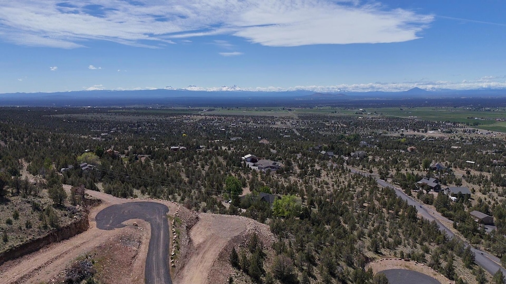
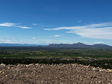
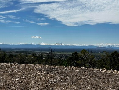
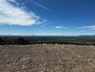
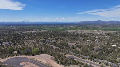
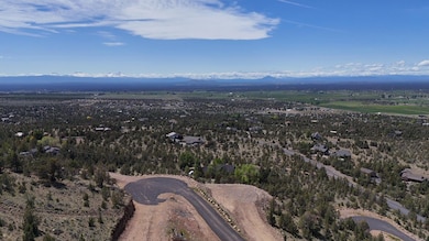
This exceptional lot in Powell Butte isn't just a place to build—it's the foundation for a truly one-of-a-kind home. Perched nearly 200 feet above the road, the homesite offers unmatched privacy and panoramic views stretching from Pilot Butte to the Ochoco National Forest. You'll experience the full splendor of Central Oregon's natural beauty, right from your doorstep. The lot comes ready with a completed driveway, power, and Avion water already to the site. Plus, a private easement provides direct access to public lands just south of the property—perfect for adventure and exploration. Ready to start your forever home? Contact us today to walk the land and take in the view.
Property Details
Property Type
- Land
Est. Annual Taxes
- $812
Lot Details
- 4.85 Acre Lot
- Barbed Wire
- Rock Outcropping
- Sloped Lot
- Property is zoned R5; Rural Residential, R5; Rural Residential
Property Views
- Panoramic
- Mountain
- Valley
Schools
- Powell Butte Elementary School
- Crook County Middle School
- Crook County High School
Community Details
- No Home Owners Association
- Powell Butte View Subdivision
- Property is near a preserve or public land
Listing and Financial Details
- Assessor Parcel Number 1356
- Tax Block 8
Map
Home Values in the Area
Average Home Value in this Area
Tax History
| Year | Tax Paid | Tax Assessment Tax Assessment Total Assessment is a certain percentage of the fair market value that is determined by local assessors to be the total taxable value of land and additions on the property. | Land | Improvement |
|---|---|---|---|---|
| 2025 | $832 | $68,510 | -- | -- |
| 2024 | $812 | $66,520 | -- | -- |
| 2023 | $785 | $64,590 | $0 | $0 |
| 2022 | $1,141 | $94,140 | $0 | $0 |
| 2021 | $1,141 | $91,400 | $0 | $0 |
| 2020 | $1,109 | $88,743 | $0 | $0 |
| 2019 | $1,070 | $83,649 | $0 | $0 |
| 2018 | $1,043 | $83,649 | $0 | $0 |
| 2017 | $1,027 | $81,213 | $0 | $0 |
| 2016 | $980 | $76,551 | $0 | $0 |
| 2015 | $938 | $76,551 | $0 | $0 |
| 2013 | -- | $72,156 | $0 | $0 |
Property History
| Date | Event | Price | List to Sale | Price per Sq Ft |
|---|---|---|---|---|
| 11/19/2025 11/19/25 | Price Changed | $385,000 | -3.5% | -- |
| 09/17/2025 09/17/25 | Price Changed | $399,000 | -3.9% | -- |
| 08/18/2025 08/18/25 | Price Changed | $415,000 | -16.2% | -- |
| 06/09/2025 06/09/25 | Price Changed | $495,000 | -9.2% | -- |
| 05/31/2025 05/31/25 | For Sale | $545,000 | -- | -- |
Purchase History
| Date | Type | Sale Price | Title Company |
|---|---|---|---|
| Warranty Deed | -- | None Listed On Document | |
| Warranty Deed | $125,000 | Amerititle | |
| Interfamily Deed Transfer | -- | None Available |
Source: Oregon Datashare
MLS Number: 220203006
APN: 001356
Disclaimer: Certain information contained herein is derived from information provided by parties other than Homes.com. All information provided is deemed reliable, but is not guaranteed to be accurate and should be independently verified.
![]() © 2025 Oregon Datashare (KCAR | MLSCO | SOMLS). All rights reserved. The data relating to real estate for sale on this web site comes in part from the Internet Data Exchange Program of the Oregon Datashare. Real estate listings held by IDX Brokerage firms other than Ten-X are marked with the Internet Data Exchange logo or the Internet Data Exchange thumbnail logo and detailed information about them includes the name of the listing Brokers. Information provided is for consumers' personal, non-commercial use and may not be used for any purpose other than to identify prospective properties the viewer may be interested in purchasing. The consumer will not copy, retransmit nor redistribute any of the content from this website. Information provided is deemed reliable, but not guaranteed.
© 2025 Oregon Datashare (KCAR | MLSCO | SOMLS). All rights reserved. The data relating to real estate for sale on this web site comes in part from the Internet Data Exchange Program of the Oregon Datashare. Real estate listings held by IDX Brokerage firms other than Ten-X are marked with the Internet Data Exchange logo or the Internet Data Exchange thumbnail logo and detailed information about them includes the name of the listing Brokers. Information provided is for consumers' personal, non-commercial use and may not be used for any purpose other than to identify prospective properties the viewer may be interested in purchasing. The consumer will not copy, retransmit nor redistribute any of the content from this website. Information provided is deemed reliable, but not guaranteed.
- 8956 SW Yahooskin Dr
- 10300 SW Nicole Dr
- 0 Pp 2009-06 Parcel 2 Riggs Rd
- 7006 SW Joshua Ct
- 6904 SW Joshua Ct
- 9444 SW Copper Rd
- 8844 SW Copley Rd
- 9280 SW Copley Rd
- 8385 SW Copley Rd
- 13689 SW Bussett Rd
- 13501 SW Riggs Rd
- 0 Talarus Tr
- 0 SW Reif Rd Unit 220210897
- 0 SW Parrish Ln Unit 416136612
- 10934 SW Fleming Rd
- 7305 SW Highway 126
- 11311 SW Fleming Rd
- 7536 SW Powell Butte Hwy
- 13646 SW Meadowlark
- 8055 SW Powell Butte Hwy
- 940 NW 2nd St
- 933 NW Cains Rd
- 935 NW Cains Rd
- 2252 NE Colleen Rd
- 629 SW 5th St
- 748 NE Oak Place Unit 748 NE Oak Place, Redmond, OR 97756
- 748 NE Oak Place
- 787 NW Canal Blvd
- 1329 SW Pumice Ave
- 1950 SW Umatilla Ave
- 532 SW Rimrock Way
- 418 NW 17th St Unit 3
- 3025 NW 7th St
- 4455 NE Vaughn Ave Unit The Prancing Peacock
- 4455 NE Vaughn Ave Unit The Prancing Peacock
- 3759 SW Badger Ave
- 3750 SW Badger Ave
- 4633 SW 37th St
- 4399 SW Coyote Ave
- 2960 NW Northwest Way
