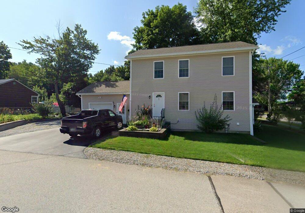
1 Als Ave Allenstown, NH 03275
Suncook NeighborhoodEstimated Value: $427,000 - $488,998
3
Beds
2
Baths
1,845
Sq Ft
$248/Sq Ft
Est. Value
About This Home
This home is located at 1 Als Ave, Allenstown, NH 03275 and is currently estimated at $458,250, approximately $248 per square foot. 1 Als Ave is a home with nearby schools including Allenstown Elementary School, Armand R. Dupont School, and Tender Years Child Care & Learning Center.
Ownership History
Date
Name
Owned For
Owner Type
Purchase Details
Closed on
Sep 16, 2013
Sold by
Akb Constr Llc
Bought by
Kingsbury Anthony
Current Estimated Value
Create a Home Valuation Report for This Property
The Home Valuation Report is an in-depth analysis detailing your home's value as well as a comparison with similar homes in the area
Home Values in the Area
Average Home Value in this Area
Purchase History
| Date | Buyer | Sale Price | Title Company |
|---|---|---|---|
| Kingsbury Anthony | $185,000 | -- | |
| Kingsbury Anthony | $185,000 | -- |
Source: Public Records
Mortgage History
| Date | Status | Borrower | Loan Amount |
|---|---|---|---|
| Closed | Kingsbury Anthony | $0 |
Source: Public Records
Tax History Compared to Growth
Tax History
| Year | Tax Paid | Tax Assessment Tax Assessment Total Assessment is a certain percentage of the fair market value that is determined by local assessors to be the total taxable value of land and additions on the property. | Land | Improvement |
|---|---|---|---|---|
| 2024 | $9,810 | $385,900 | $143,500 | $242,400 |
| 2023 | $8,181 | $385,900 | $143,500 | $242,400 |
| 2022 | $7,525 | $385,900 | $143,500 | $242,400 |
| 2021 | $7,176 | $227,800 | $80,400 | $147,400 |
| 2020 | $6,675 | $227,800 | $80,400 | $147,400 |
| 2019 | $7,085 | $227,800 | $80,400 | $147,400 |
| 2018 | $6,868 | $227,800 | $80,400 | $147,400 |
| 2017 | $7,315 | $227,800 | $80,400 | $147,400 |
| 2016 | $6,068 | $179,200 | $54,200 | $125,000 |
| 2015 | $5,880 | $179,100 | $54,200 | $124,900 |
| 2014 | $6,050 | $179,100 | $54,200 | $124,900 |
| 2013 | $3,393 | $107,600 | $51,500 | $56,100 |
Source: Public Records
Map
Nearby Homes
- 15 Main St
- 4 Rodger Rd
- 7 Ferry St
- 422 Dawn Dr Unit 23
- 427 Dawn Dr Unit 15
- 100 Main St Unit M10
- 100 Main St Unit 204
- 111 Glass St
- 12-14 Church St Unit 12,14
- 1 1/2 Bartlett St
- 19 Sullivan Dr
- 10 Lane Dr
- 2 Cheryl Dr
- 1821 Hooksett Rd
- 15 Sullivan Dr
- 233 Pembroke St
- 307 Dearborn Rd
- 259 Pembroke St
- 62 Pine St
- 10 Winchester Ct