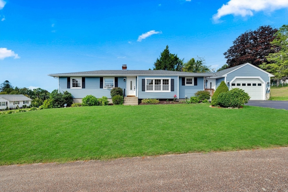


1 Amesbury St Auburn, MA 01501
Pakachoag NeighborhoodEstimated payment $3,767/month
Highlights
- Golf Course Community
- Open Floorplan
- Ranch Style House
- Scenic Views
- Deck
- Wood Flooring
About This Home
Beautiful Oversized RANCH with IN-LAW Apartment – Sought-After Pakachoag Neighborhood, Auburn. Welcome to this spacious and versatile RANCH, perfectly designed for EXTENDED FAMILY living or RENTAL opportunities. This home offers comfort, functionality, and plenty of natural light throughout. The main level features a bright, inviting living room that flows seamlessly into the dining area and kitchen. A large front-to-back family room with laundry and a half bath adds even more living space. 3 comfortable bedrooms and full bath complete the main floor. A breezeway connects to the oversized attached garage. The walk-out lower level boasts a private IN-LAW SUITE w 2 separate entrances. This well-appointed space includes full kitchen, dining area, spacious living areas, 1-2 bedrooms, a full bath, and its own private driveway, ideal for extended family, guests, or rental income. Generous LOT at the end of a dead end, near shopping, dining, schools, major highways, Golf & Rec Complex for all
Open House Schedule
-
Saturday, September 27, 202511:00 am to 1:00 pm9/27/2025 11:00:00 AM +00:009/27/2025 1:00:00 PM +00:00Add to Calendar
Home Details
Home Type
- Single Family
Est. Annual Taxes
- $7,034
Year Built
- Built in 1965 | Remodeled
Lot Details
- 0.36 Acre Lot
- Street terminates at a dead end
- Corner Lot
- Gentle Sloping Lot
Parking
- 1 Car Attached Garage
- Oversized Parking
- Parking Storage or Cabinetry
- Workshop in Garage
- Garage Door Opener
- Open Parking
- Off-Street Parking
Home Design
- Ranch Style House
- Frame Construction
- Blown Fiberglass Insulation
- Cellulose Insulation
- Shingle Roof
- Concrete Perimeter Foundation
- Stone
Interior Spaces
- Open Floorplan
- Sheet Rock Walls or Ceilings
- Ceiling Fan
- Decorative Lighting
- Light Fixtures
- Window Screens
- Dining Area
- Scenic Vista Views
- Home Security System
Kitchen
- Oven
- Range
- Microwave
- Second Dishwasher
- ENERGY STAR Qualified Dishwasher
- Upgraded Countertops
- Trash Compactor
- Disposal
Flooring
- Wood
- Wall to Wall Carpet
- Laminate
- Ceramic Tile
- Vinyl
Bedrooms and Bathrooms
- 4 Bedrooms
- In-Law or Guest Suite
Laundry
- ENERGY STAR Qualified Dryer
- Dryer
- ENERGY STAR Qualified Washer
Finished Basement
- Walk-Out Basement
- Basement Fills Entire Space Under The House
- Interior Basement Entry
Outdoor Features
- Deck
- Patio
- Outdoor Storage
- Rain Gutters
- Porch
Schools
- Pakachoag Elementary School
- Auburn Middle School
- Auburn High School
Utilities
- Cooling System Mounted In Outer Wall Opening
- Window Unit Cooling System
- 8 Heating Zones
- Heating System Uses Oil
- Baseboard Heating
- 220 Volts
- 200+ Amp Service
- 100 Amp Service
- Water Heater
- High Speed Internet
Additional Features
- ENERGY STAR Qualified Equipment for Heating
- Property is near schools
Listing and Financial Details
- Assessor Parcel Number M:0012 L:0055,1454699
Community Details
Overview
- No Home Owners Association
- Pakachoag Subdivision
Amenities
- Shops
Recreation
- Golf Course Community
- Jogging Path
Map
Home Values in the Area
Average Home Value in this Area
Tax History
| Year | Tax Paid | Tax Assessment Tax Assessment Total Assessment is a certain percentage of the fair market value that is determined by local assessors to be the total taxable value of land and additions on the property. | Land | Improvement |
|---|---|---|---|---|
| 2025 | $70 | $492,200 | $139,100 | $353,100 |
| 2024 | $7,325 | $490,600 | $133,100 | $357,500 |
| 2023 | $7,057 | $444,400 | $121,100 | $323,300 |
| 2022 | $6,531 | $388,300 | $121,100 | $267,200 |
| 2021 | $5,378 | $352,600 | $106,900 | $245,700 |
| 2020 | $12,742 | $352,600 | $106,900 | $245,700 |
| 2019 | $6,023 | $327,000 | $105,900 | $221,100 |
| 2018 | $11,945 | $318,100 | $99,000 | $219,100 |
| 2017 | $5,665 | $308,900 | $89,800 | $219,100 |
| 2016 | $5,347 | $295,600 | $93,400 | $202,200 |
| 2015 | $4,904 | $284,100 | $93,400 | $190,700 |
| 2014 | $4,613 | $266,800 | $88,900 | $177,900 |
Property History
| Date | Event | Price | Change | Sq Ft Price |
|---|---|---|---|---|
| 09/22/2025 09/22/25 | Pending | -- | -- | -- |
| 09/20/2025 09/20/25 | Price Changed | $599,900 | -4.8% | $226 / Sq Ft |
| 09/09/2025 09/09/25 | For Sale | $629,900 | -- | $237 / Sq Ft |
Purchase History
| Date | Type | Sale Price | Title Company |
|---|---|---|---|
| Deed | -- | -- |
Source: MLS Property Information Network (MLS PIN)
MLS Number: 73427924
APN: AUBU-000012-000000-000055
Disclaimer: Certain information contained herein is derived from information provided by parties other than Homes.com. All information provided is deemed reliable, but is not guaranteed to be accurate and should be independently verified.
![]() The property listing data and information, or the Images, set forth herein were provided to MLS Property Information Network, Inc. from third party sources, including sellers, lessors and public records, and were compiled by MLS Property Information Network, Inc. The property listing data and information, and the Images, are for the personal, non-commercial use of consumers having a good faith interest in purchasing or leasing listed properties of the type displayed to them and may not be used for any purpose other than to identify prospective properties which such consumers may have a good faith interest in purchasing or leasing. MLS Property Information Network, Inc. and its subscribers disclaim any and all representations and warranties as to the accuracy of the property listing data and information, or as to the accuracy of any of the Images, set forth herein.
The property listing data and information, or the Images, set forth herein were provided to MLS Property Information Network, Inc. from third party sources, including sellers, lessors and public records, and were compiled by MLS Property Information Network, Inc. The property listing data and information, and the Images, are for the personal, non-commercial use of consumers having a good faith interest in purchasing or leasing listed properties of the type displayed to them and may not be used for any purpose other than to identify prospective properties which such consumers may have a good faith interest in purchasing or leasing. MLS Property Information Network, Inc. and its subscribers disclaim any and all representations and warranties as to the accuracy of the property listing data and information, or as to the accuracy of any of the Images, set forth herein.
- 204-212 Hampton St
- 216-220 Hampton St
- 104 Elmwood St
- 61 Elmwood St
- 115 Pakachoag St
- 32 Field St
- 45 Jerome Ave
- 10 Meadowbrook Rd
- 15 Lesley Ave
- 7 Manor Rd
- 801 Forest Park Dr Unit 801
- 4 Bay Ridge Rd
- 7 W Hampton St
- 125 Malvern Rd
- 40 Sophia Dr
- 28 Bittersweet Blvd
- 22 Bittersweet Blvd
- 101 Whipple St Unit 101-16
- 8 Shirley St
- 47 Washington St Unit 54
