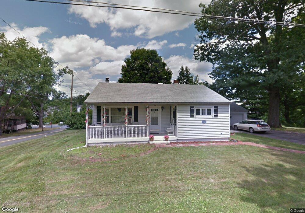
1 Carrie Ln Middletown, NY 10940
Estimated Value: $305,000 - $367,000
2
Beds
1
Bath
1,032
Sq Ft
$338/Sq Ft
Est. Value
About This Home
This home is located at 1 Carrie Ln, Middletown, NY 10940 and is currently estimated at $349,150, approximately $338 per square foot. 1 Carrie Ln is a home located in Orange County with nearby schools including Presidential Park Elementary School, Middletown Twin Towers Middle School, and Monhagen Middle School.
Ownership History
Date
Name
Owned For
Owner Type
Purchase Details
Closed on
Dec 5, 2001
Sold by
Hud
Bought by
Mahabir Richard
Current Estimated Value
Home Financials for this Owner
Home Financials are based on the most recent Mortgage that was taken out on this home.
Original Mortgage
$113,500
Interest Rate
7.15%
Purchase Details
Closed on
Oct 6, 2000
Sold by
Wells Fargo Home Mtg Inc
Bought by
Hud
Purchase Details
Closed on
Aug 3, 2000
Sold by
Valentine Edward and Valentine Cheryl A
Bought by
Wells Fargo Home Mtg Inc
Create a Home Valuation Report for This Property
The Home Valuation Report is an in-depth analysis detailing your home's value as well as a comparison with similar homes in the area
Home Values in the Area
Average Home Value in this Area
Purchase History
| Date | Buyer | Sale Price | Title Company |
|---|---|---|---|
| Mahabir Richard | $101,050 | -- | |
| Hud | -- | -- | |
| Wells Fargo Home Mtg Inc | $146,964 | -- |
Source: Public Records
Mortgage History
| Date | Status | Borrower | Loan Amount |
|---|---|---|---|
| Previous Owner | Mahabir Richard | $113,500 |
Source: Public Records
Tax History Compared to Growth
Tax History
| Year | Tax Paid | Tax Assessment Tax Assessment Total Assessment is a certain percentage of the fair market value that is determined by local assessors to be the total taxable value of land and additions on the property. | Land | Improvement |
|---|---|---|---|---|
| 2024 | $5,846 | $46,100 | $5,400 | $40,700 |
| 2023 | $5,846 | $38,300 | $5,400 | $32,900 |
| 2022 | $6,038 | $38,300 | $5,400 | $32,900 |
| 2021 | $6,410 | $38,300 | $5,400 | $32,900 |
| 2020 | $1,864 | $38,300 | $5,400 | $32,900 |
| 2019 | $3,767 | $38,300 | $5,400 | $32,900 |
| 2018 | $5,572 | $38,300 | $5,400 | $32,900 |
| 2017 | $5,689 | $38,800 | $5,400 | $33,400 |
| 2016 | $5,410 | $38,800 | $5,400 | $33,400 |
| 2015 | -- | $38,800 | $5,400 | $33,400 |
| 2014 | -- | $38,800 | $5,400 | $33,400 |
Source: Public Records
Map
Nearby Homes
- 15 Clark St
- TBD Silver Lake-Scotchtown Rd
- 24 3rd St
- 105 Sheffield Dr
- 36 Bert Crawford Rd
- 57 Overhill Rd
- 21 Cyprus Dr
- 1 Polly Kay Dr
- 115 Vincent Dr
- 24 Juniper Cir
- 5 Cobblestone Ln Unit 4301
- 4 Avoncroft Ln
- 30 Avoncroft Ln
- 47 Carpenter Ave
- 23 Avoncroft Ln
- 299 Highland Ave Extension
- 80 Beattie Ave
- 143 N Beacon St
- 26 Kyleigh Way
- 37 Wisner Ave Unit 39
- 102 Silver Lake Scotchtown Rd
- 43 2nd St
- 2 Carrie Ln
- 41 2nd St
- 39 2nd St
- 1 2nd St
- 5 Carrie Ln
- 95 Silver Lake Scotchtown Rd
- 85 Silver Lake Scotchtown Rd
- 85 Lake Ave
- 17 Carrie Ln
- 110 Silver Lake Scotchtown Rd
- 82 Silver Lake Scotchtown Rd
- 8 Clark St
- 10 Carrie Ln
- 21 Clark St
- 4 First Ave
- 81 Silver Lake Scotchtown Rd Unit 4
- 11 Carrie Ln
- 16 Clark St Unit 18