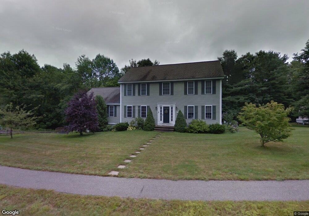
1 Crestview Dr Rutland, MA 01543
Estimated Value: $627,744 - $699,000
4
Beds
3
Baths
2,304
Sq Ft
$291/Sq Ft
Est. Value
About This Home
This home is located at 1 Crestview Dr, Rutland, MA 01543 and is currently estimated at $669,686, approximately $290 per square foot. 1 Crestview Dr is a home located in Worcester County with nearby schools including Wachusett Regional High School.
Ownership History
Date
Name
Owned For
Owner Type
Purchase Details
Closed on
May 15, 2024
Sold by
Burke Brendan C and Burke Lynne S
Bought by
Burke Ft and Burke
Current Estimated Value
Purchase Details
Closed on
Dec 8, 2000
Sold by
Cb Blair Dev Corp
Bought by
Burke Brendan C and Burke Lynne S
Create a Home Valuation Report for This Property
The Home Valuation Report is an in-depth analysis detailing your home's value as well as a comparison with similar homes in the area
Home Values in the Area
Average Home Value in this Area
Purchase History
| Date | Buyer | Sale Price | Title Company |
|---|---|---|---|
| Burke Ft | -- | None Available | |
| Burke Ft | -- | None Available | |
| Burke Brendan C | $269,900 | -- | |
| Burke Brendan C | $269,900 | -- |
Source: Public Records
Mortgage History
| Date | Status | Borrower | Loan Amount |
|---|---|---|---|
| Previous Owner | Burke Brendan C | $263,000 | |
| Previous Owner | Burke Brendan C | $55,000 | |
| Previous Owner | Burke Brendan C | $260,000 |
Source: Public Records
Tax History
| Year | Tax Paid | Tax Assessment Tax Assessment Total Assessment is a certain percentage of the fair market value that is determined by local assessors to be the total taxable value of land and additions on the property. | Land | Improvement |
|---|---|---|---|---|
| 2025 | $7,587 | $532,800 | $112,200 | $420,600 |
| 2024 | $7,178 | $484,000 | $100,700 | $383,300 |
| 2023 | $6,516 | $474,900 | $95,000 | $379,900 |
| 2022 | $6,109 | $386,900 | $80,300 | $306,600 |
| 2021 | $5,950 | $356,300 | $80,300 | $276,000 |
| 2020 | $5,760 | $327,100 | $75,600 | $251,500 |
| 2019 | $5,691 | $318,100 | $69,300 | $248,800 |
| 2018 | $5,472 | $301,800 | $69,300 | $232,500 |
| 2017 | $5,529 | $301,800 | $69,300 | $232,500 |
| 2016 | $5,195 | $299,100 | $66,700 | $232,400 |
| 2015 | $5,129 | $290,600 | $66,700 | $223,900 |
| 2014 | $4,972 | $290,600 | $66,700 | $223,900 |
Source: Public Records
Map
Nearby Homes
- 569 E County Rd
- 35 Brintnal Dr
- 14 Grizzly Dr
- 140 Ridge Rd
- 16 Richards Ave
- 147 E County Rd Unit 149
- 139 E County Rd Unit 139
- 5 Miles Rd
- 56 Hubbardston Rd
- 45 Old Colony Rd
- 90 Woodside Ave
- 30 Woodside Ave
- 22 Village Way
- 17 Village Way
- 28 Forest Hill Dr
- 13 Woodside Ave
- 11 Lewis St
- 21 Lewis St
- 27 Lewis St
- 12 Lewis St
- 3 Crestview Dr
- 36 Campbell St
- 5 Crestview Dr
- 55 Campbell St
- 51 Campbell St
- 32 Campbell St
- 59 Campbell St
- 9 Crestview Dr
- 10 Crestview Dr
- 47 Campbell St
- 43 Campbell St
- 63 Campbell St
- 12 Crestview Dr
- 11 Crestview Dr
- 41 Campbell St
- 62 Campbell St
- 14 Crestview Dr
- 60 Campbell St
- 58 Campbell St
- 15 Crestview Dr
Your Personal Tour Guide
Ask me questions while you tour the home.