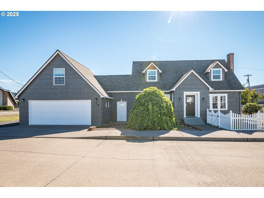
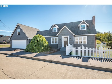
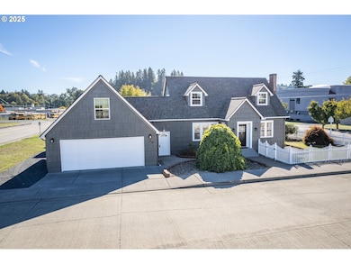
1 D St SW Castle Rock, WA 98611
Estimated payment $2,647/month
Highlights
- RV Access or Parking
- Wood Flooring
- No HOA
- Cape Cod Architecture
- Corner Lot
- Home Office
About This Home
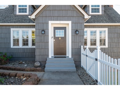
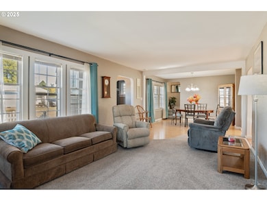
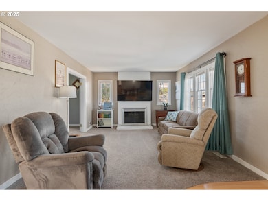
We've got a Castle Rock charmer here! So many updates but still has the original charm of a 20's Cape Cod! Tons of curb appeal w/a low maintenance yard to boot. Centrally located with the ease of being by the schools, and downtown. 3 bed 2 baths w/a cozy living room that has a fireplace and den/office with the beautiful original French doors. Updates are plentiful and aren't limited to, new exterior paint, newer roof, new vinyl windows upstairs, newer electrical panel, RV plug, kitchen with a big island, main level bathroom remodel, and recessed lighting. RV/boat storage is a plus too! It's even got a heat pump! Oversized 2 car garage with an unfinished bonus space above. This is a must see home, it's ready for new owners!
Home Details
Home Type
- Single Family
Est. Annual Taxes
- $3,259
Year Built
- Built in 1926
Lot Details
- Corner Lot
Parking
- 2 Car Attached Garage
- Driveway
- RV Access or Parking
Home Design
- Cape Cod Architecture
- Composition Roof
- Wood Siding
- Shake Siding
- Cedar
Interior Spaces
- 2,588 Sq Ft Home
- 2-Story Property
- Ceiling Fan
- Recessed Lighting
- Wood Burning Fireplace
- Double Pane Windows
- Vinyl Clad Windows
- Wood Frame Window
- Family Room
- Living Room
- Dining Room
- Home Office
- Laundry Room
- Unfinished Basement
Kitchen
- Free-Standing Range
- Microwave
- Dishwasher
Flooring
- Wood
- Laminate
- Vinyl
Bedrooms and Bathrooms
- 3 Bedrooms
Schools
- Castle Rock Elementary And Middle School
- Castle Rock High School
Utilities
- Cooling Available
- Forced Air Heating System
- Heat Pump System
Community Details
- No Home Owners Association
Listing and Financial Details
- Assessor Parcel Number 30285
Map
Home Values in the Area
Average Home Value in this Area
Tax History
| Year | Tax Paid | Tax Assessment Tax Assessment Total Assessment is a certain percentage of the fair market value that is determined by local assessors to be the total taxable value of land and additions on the property. | Land | Improvement |
|---|---|---|---|---|
| 2024 | $3,259 | $385,090 | $46,300 | $338,790 |
| 2023 | $2,863 | $349,770 | $46,300 | $303,470 |
| 2022 | $2,751 | $351,860 | $36,210 | $315,650 |
| 2021 | $2,680 | $299,260 | $31,760 | $267,500 |
| 2020 | $2,495 | $272,060 | $28,880 | $243,180 |
| 2019 | $2,302 | $260,079 | $26,250 | $233,829 |
| 2018 | $2,255 | $224,410 | $26,250 | $198,160 |
| 2017 | $1,700 | $191,270 | $25,000 | $166,270 |
| 2016 | $1,574 | $141,380 | $22,500 | $118,880 |
| 2015 | $1,601 | $137,920 | $22,500 | $115,420 |
| 2013 | -- | $147,290 | $22,500 | $124,790 |
Property History
| Date | Event | Price | List to Sale | Price per Sq Ft |
|---|---|---|---|---|
| 11/19/2025 11/19/25 | Price Changed | $449,900 | -4.3% | $174 / Sq Ft |
| 10/20/2025 10/20/25 | For Sale | $469,900 | -- | $182 / Sq Ft |
Purchase History
| Date | Type | Sale Price | Title Company |
|---|---|---|---|
| Interfamily Deed Transfer | -- | First American Title | |
| Interfamily Deed Transfer | -- | None Available |
Mortgage History
| Date | Status | Loan Amount | Loan Type |
|---|---|---|---|
| Closed | $186,300 | New Conventional |
Source: Regional Multiple Listing Service (RMLS)
MLS Number: 685805838
APN: 3-0285
Disclaimer: Certain information contained herein is derived from information provided by parties other than Homes.com. All information provided is deemed reliable, but is not guaranteed to be accurate and should be independently verified.
![]() The content relating to real estate for sale on this web site comes in part from the IDX program of the RMLS™ of Portland, Oregon. Real estate listings held by brokerage firms other than Ten-X are marked with the RMLS™ logo, and detailed information about these properties includes the names of the listing brokers. Listing content is copyright © 2025 RMLS™, Portland, Oregon. Some properties which appear for sale on this web site may subsequently have sold or may no longer be available. All information provided is deemed reliable but is not guaranteed and should be independently verified.
The content relating to real estate for sale on this web site comes in part from the IDX program of the RMLS™ of Portland, Oregon. Real estate listings held by brokerage firms other than Ten-X are marked with the RMLS™ logo, and detailed information about these properties includes the names of the listing brokers. Listing content is copyright © 2025 RMLS™, Portland, Oregon. Some properties which appear for sale on this web site may subsequently have sold or may no longer be available. All information provided is deemed reliable but is not guaranteed and should be independently verified.
- 438 Front Ave SW
- 705 1st Ave SW
- 237 C St SW
- 203 Roake Ave SE
- 546 4th Ave SW
- 411 Brierwood Ct SE
- 411 4th Ave SW
- 642 5th Ave SW
- 1020 3rd Ave SW
- 741 5th Ave SW
- 385 Front Ave NW
- 114 Cherry St NW
- 0 Pioneer Ave NE
- 0 Huntington Ave S Unit NWM2336096
- 611 Pioneer Ave NE
- 129 Winfield Dr
- 715 NE Pioneer Ave NE
- 6609 Westside Hwy
- 730 Little Ave NE
- 107 Guinevere Ct
