
1 Driftwood Rd Rockport, MA 01966
Estimated Value: $939,000 - $1,170,000
2
Beds
2
Baths
1,682
Sq Ft
$632/Sq Ft
Est. Value
About This Home
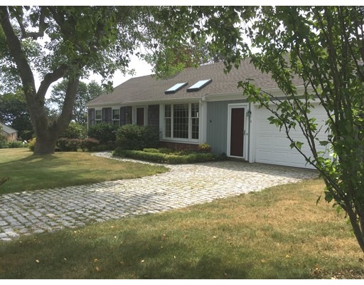
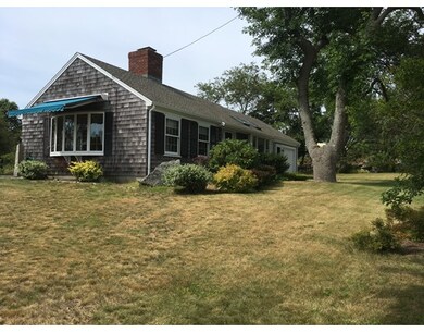
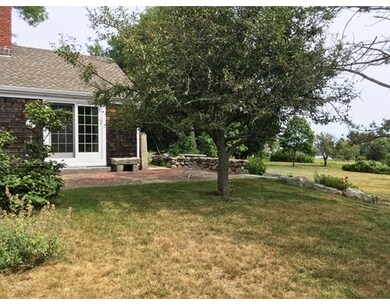
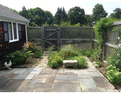
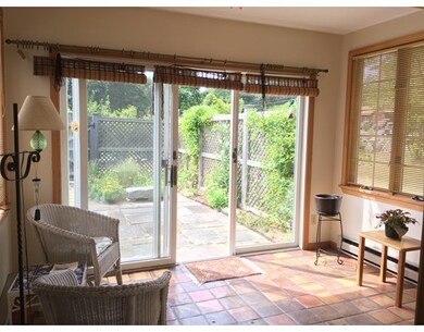
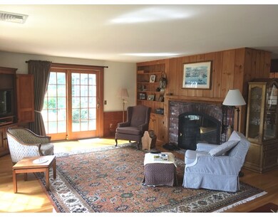
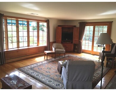
As of November 2017Opportunity to own a classic Royal Barry Wills home on one of the most picturesque roads in Rockport just steps from the Atlantic! This enchanting, meticulously kept property features a large light filled LR with oversized wood burning fireplace & extra large windows to take in the ocean views beyond a beautiful oversized lot. Hardwood floors throughout and sliding door leading out to a private patio area. The kitchen is light and bright with 2 skylights and easy access to the garage and sunroom. The sunroom has sliding door leading out to another private patio garden area. There are 2 BR's, 2 BA's a large dry basement that could easily be used as additional living space. Very efficient home with new roof and new septic system. Must see!
Home Details
Home Type
- Single Family
Est. Annual Taxes
- $8,199
Year Built
- 1965
Lot Details
- 0.51
Utilities
- Private Sewer
Similar Homes in the area
Create a Home Valuation Report for This Property
The Home Valuation Report is an in-depth analysis detailing your home's value as well as a comparison with similar homes in the area
Home Values in the Area
Average Home Value in this Area
Mortgage History
| Date | Status | Borrower | Loan Amount |
|---|---|---|---|
| Closed | Lane Daniel P | $25,000 |
Source: Public Records
Property History
| Date | Event | Price | Change | Sq Ft Price |
|---|---|---|---|---|
| 11/30/2017 11/30/17 | Sold | $625,000 | -10.1% | $372 / Sq Ft |
| 10/12/2017 10/12/17 | Pending | -- | -- | -- |
| 10/10/2017 10/10/17 | Price Changed | $695,000 | -4.1% | $413 / Sq Ft |
| 09/21/2017 09/21/17 | For Sale | $725,000 | 0.0% | $431 / Sq Ft |
| 09/19/2017 09/19/17 | Pending | -- | -- | -- |
| 08/17/2017 08/17/17 | For Sale | $725,000 | -- | $431 / Sq Ft |
Source: MLS Property Information Network (MLS PIN)
Tax History Compared to Growth
Tax History
| Year | Tax Paid | Tax Assessment Tax Assessment Total Assessment is a certain percentage of the fair market value that is determined by local assessors to be the total taxable value of land and additions on the property. | Land | Improvement |
|---|---|---|---|---|
| 2025 | $8,199 | $936,000 | $500,500 | $435,500 |
| 2024 | $7,785 | $924,600 | $489,100 | $435,500 |
| 2023 | $7,364 | $780,900 | $409,500 | $371,400 |
| 2022 | $7,168 | $729,900 | $377,700 | $352,200 |
| 2021 | $6,772 | $695,300 | $359,700 | $335,600 |
| 2020 | $7,147 | $707,600 | $404,800 | $302,800 |
| 2019 | $6,530 | $662,300 | $400,500 | $261,800 |
| 2018 | $6,164 | $609,700 | $373,800 | $235,900 |
| 2017 | $5,986 | $530,700 | $339,000 | $191,700 |
| 2016 | $5,995 | $532,900 | $341,200 | $191,700 |
| 2015 | $5,655 | $514,100 | $329,500 | $184,600 |
| 2014 | $5,510 | $488,900 | $305,900 | $183,000 |
Source: Public Records
Agents Affiliated with this Home
-
Rick Olson
Seller's Agent in 2017
Rick Olson
Olson Real Estate
(978) 546-7181
25 in this area
30 Total Sales
Map
Source: MLS Property Information Network (MLS PIN)
MLS Number: 72215101
APN: ROCK-000031-000000-000006
Disclaimer: Certain information contained herein is derived from information provided by parties other than Homes.com. All information provided is deemed reliable, but is not guaranteed to be accurate and should be independently verified.
![]() The property listing data and information, or the Images, set forth herein were provided to MLS Property Information Network, Inc. from third party sources, including sellers, lessors and public records, and were compiled by MLS Property Information Network, Inc. The property listing data and information, and the Images, are for the personal, non-commercial use of consumers having a good faith interest in purchasing or leasing listed properties of the type displayed to them and may not be used for any purpose other than to identify prospective properties which such consumers may have a good faith interest in purchasing or leasing. MLS Property Information Network, Inc. and its subscribers disclaim any and all representations and warranties as to the accuracy of the property listing data and information, or as to the accuracy of any of the Images, set forth herein.
The property listing data and information, or the Images, set forth herein were provided to MLS Property Information Network, Inc. from third party sources, including sellers, lessors and public records, and were compiled by MLS Property Information Network, Inc. The property listing data and information, and the Images, are for the personal, non-commercial use of consumers having a good faith interest in purchasing or leasing listed properties of the type displayed to them and may not be used for any purpose other than to identify prospective properties which such consumers may have a good faith interest in purchasing or leasing. MLS Property Information Network, Inc. and its subscribers disclaim any and all representations and warranties as to the accuracy of the property listing data and information, or as to the accuracy of any of the Images, set forth herein.
Nearby Homes
- 84 South St
- 65 South St
- 48 Eden Rd
- 49 South St
- 5 Smith Rd
- 19 Old Garden Rd
- 10 Old Penzance Rd
- 5 Allen Ave
- 8 Norwood Ave
- 23 Atlantic Ave
- 1 Gott St
- 10 Mt Pleasant Unit B
- 10 Mt Pleasant Unit A
- 30 Highview Rd
- 1 Dock Square
- 42 Bearskin Neck
- 1 Jewett St Unit 1
- 1 Jewett St Unit 2
- 36 Broadway Ave
- 2 Highland St Unit 1