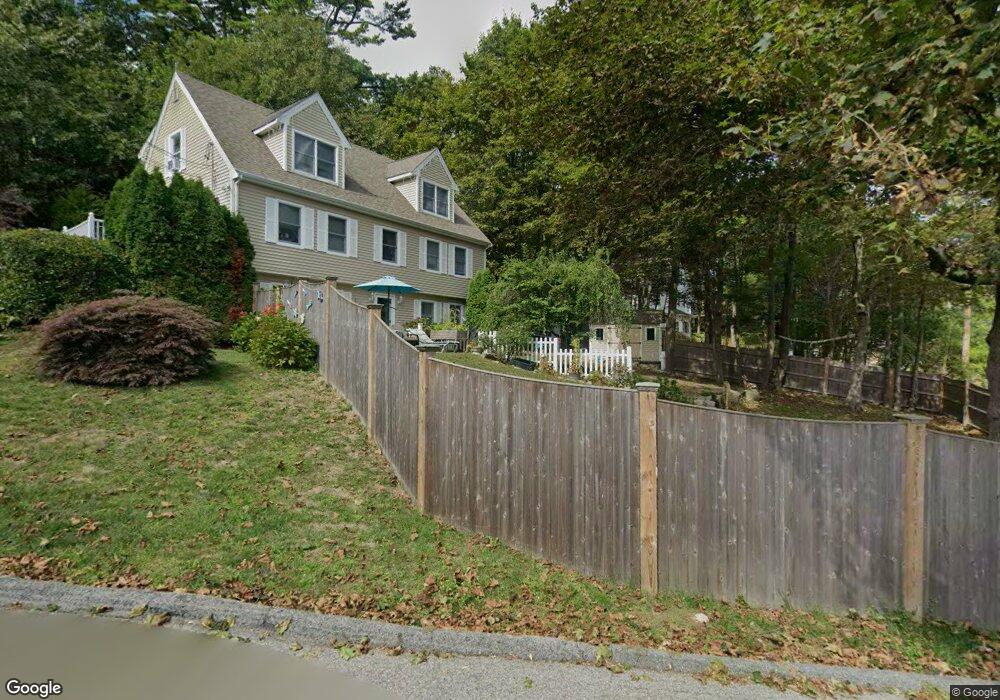
1 Gibbs Hill Rd Gloucester, MA 01930
West Gloucester NeighborhoodEstimated Value: $769,385 - $879,000
4
Beds
4
Baths
2,962
Sq Ft
$280/Sq Ft
Est. Value
About This Home
This home is located at 1 Gibbs Hill Rd, Gloucester, MA 01930 and is currently estimated at $829,596, approximately $280 per square foot. 1 Gibbs Hill Rd is a home located in Essex County with nearby schools including West Parish, Ralph B O'maley Middle School, and Gloucester High School.
Ownership History
Date
Name
Owned For
Owner Type
Purchase Details
Closed on
Mar 7, 2018
Sold by
Manninen Theresa A and Mannien Robert A
Bought by
Manninen Theresa A and Mannien Robert A
Current Estimated Value
Purchase Details
Closed on
Dec 15, 2000
Sold by
Blaestraci James R
Bought by
Manninen Robert C and Manninen Theresa A
Home Financials for this Owner
Home Financials are based on the most recent Mortgage that was taken out on this home.
Original Mortgage
$135,000
Interest Rate
7.7%
Mortgage Type
Purchase Money Mortgage
Create a Home Valuation Report for This Property
The Home Valuation Report is an in-depth analysis detailing your home's value as well as a comparison with similar homes in the area
Home Values in the Area
Average Home Value in this Area
Purchase History
| Date | Buyer | Sale Price | Title Company |
|---|---|---|---|
| Manninen Theresa A | -- | -- | |
| Manninen Robert C | $349,900 | -- |
Source: Public Records
Mortgage History
| Date | Status | Borrower | Loan Amount |
|---|---|---|---|
| Previous Owner | Manninen Robert C | $135,000 |
Source: Public Records
Tax History
| Year | Tax Paid | Tax Assessment Tax Assessment Total Assessment is a certain percentage of the fair market value that is determined by local assessors to be the total taxable value of land and additions on the property. | Land | Improvement |
|---|---|---|---|---|
| 2025 | $6,365 | $654,800 | $195,800 | $459,000 |
| 2024 | $6,240 | $641,300 | $186,500 | $454,800 |
| 2023 | $6,422 | $606,400 | $166,500 | $439,900 |
| 2022 | $6,037 | $514,700 | $144,900 | $369,800 |
| 2021 | $5,745 | $461,800 | $131,700 | $330,100 |
| 2020 | $5,557 | $450,700 | $131,700 | $319,000 |
| 2019 | $5,521 | $435,100 | $131,700 | $303,400 |
| 2018 | $5,418 | $419,000 | $131,700 | $287,300 |
| 2017 | $5,197 | $394,000 | $125,400 | $268,600 |
| 2016 | $5,150 | $378,400 | $130,800 | $247,600 |
| 2015 | $4,980 | $364,800 | $130,800 | $234,000 |
Source: Public Records
Map
Nearby Homes
- 5 Lepage Ln
- 24 Cobblestone Ln Unit 603
- 5 Samoset Rd Unit B
- 145 Essex Ave Unit 402
- 5 Marshfield St
- 368 Essex Ave
- 13 Leslie o Johnson Rd
- 15 Harvard St
- 3 Rockland St
- 20 Beacon St
- 20 Beacon St Unit 2
- 20 Beacon St Unit 1
- 6 Monroe Ct
- 120 Washington St
- 98 Maplewood Ave
- 8 Mystic Ave
- 33 Middle St
- 35 Middle St Unit 4
- 13 Mystic Ave
- 33 Maplewood Ave Unit 310
Your Personal Tour Guide
Ask me questions while you tour the home.