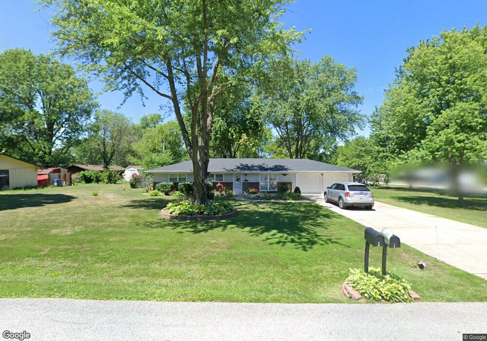
1 Gilbert Dr O Fallon, MO 63366
Estimated Value: $277,000 - $323,000
3
Beds
2
Baths
1,584
Sq Ft
$189/Sq Ft
Est. Value
About This Home
This home is located at 1 Gilbert Dr, O Fallon, MO 63366 and is currently estimated at $298,795, approximately $188 per square foot. 1 Gilbert Dr is a home located in St. Charles County with nearby schools including Crossroads Elementary School, Frontier Middle School, and Liberty High School.
Ownership History
Date
Name
Owned For
Owner Type
Purchase Details
Closed on
Aug 13, 2013
Sold by
Lesky David A and Lesky Janet L
Bought by
Armstrong Nancy
Current Estimated Value
Purchase Details
Closed on
Mar 21, 2001
Sold by
Wunderle Janet Lea and Wunderle David A
Bought by
Lesky David A and Lesky Janet L
Home Financials for this Owner
Home Financials are based on the most recent Mortgage that was taken out on this home.
Original Mortgage
$76,550
Interest Rate
6.98%
Purchase Details
Closed on
Jan 11, 1999
Sold by
Wunderle John H
Bought by
Wunderle Janet Lea
Create a Home Valuation Report for This Property
The Home Valuation Report is an in-depth analysis detailing your home's value as well as a comparison with similar homes in the area
Home Values in the Area
Average Home Value in this Area
Purchase History
| Date | Buyer | Sale Price | Title Company |
|---|---|---|---|
| Armstrong Nancy | $134,000 | None Available | |
| Lesky David A | -- | -- | |
| Wunderle Janet Lea | -- | -- |
Source: Public Records
Mortgage History
| Date | Status | Borrower | Loan Amount |
|---|---|---|---|
| Previous Owner | Lesky David A | $76,550 |
Source: Public Records
Tax History
| Year | Tax Paid | Tax Assessment Tax Assessment Total Assessment is a certain percentage of the fair market value that is determined by local assessors to be the total taxable value of land and additions on the property. | Land | Improvement |
|---|---|---|---|---|
| 2025 | $3,023 | $44,078 | -- | -- |
| 2023 | $3,024 | $42,816 | $0 | $0 |
| 2022 | $3,212 | $42,343 | $0 | $0 |
| 2021 | $3,213 | $42,343 | $0 | $0 |
| 2020 | $2,422 | $31,094 | $0 | $0 |
| 2019 | $2,273 | $31,094 | $0 | $0 |
| 2018 | $2,110 | $27,438 | $0 | $0 |
| 2017 | $2,076 | $27,438 | $0 | $0 |
| 2016 | $1,861 | $24,385 | $0 | $0 |
| 2015 | $1,852 | $24,385 | $0 | $0 |
| 2014 | $1,725 | $23,342 | $0 | $0 |
Source: Public Records
Map
Nearby Homes
- 9 Christine Dr
- 142 Royal Troon Dr
- 152 Royal Troon Dr
- 145 Royal Inverness Pkwy
- New Build Berkshire "C" @ Inverness
- TBB Glenwyck "A"@inverness
- 130 Royal Troon Dr
- 143 Royal Troon Dr
- New Build Berkshire "A" @ Inverness
- 128 Royal Troon Dr
- 610 Cruden Bay Ct
- New Build Berkshire II "D" @ Inverness
- 126 Royal Troon Dr
- 11 Warchol Ct
- 1374 Half Moon Dr
- 113 Royal Troon Dr
- 107 Royal Inverness Pkwy
- 6 Sage Meadows Ct
- 535 Crail Ct
- 321 Kingsbarns Ct
- 22 Reece Dr
- 3 Gilbert Dr
- 2 Gilbert Dr
- 23 Christine Dr
- 21 Reece Dr
- 13 Reece Dr
- 4 Gilbert Dr
- 23 Reece Dr
- 24 Reece Dr
- 11 Reece Dr
- 25 Christine Dr
- 8 Reece Dr
- 20 Christine Dr
- 25 Reece Dr
- 1338 Osage Meadows Dr
- 1342 Osage Meadows Dr
- 12 Christine Dr
- 1334 Osage Meadows Dr
- 1346 Osage Meadows Dr
- 22 Christine Dr
Your Personal Tour Guide
Ask me questions while you tour the home.