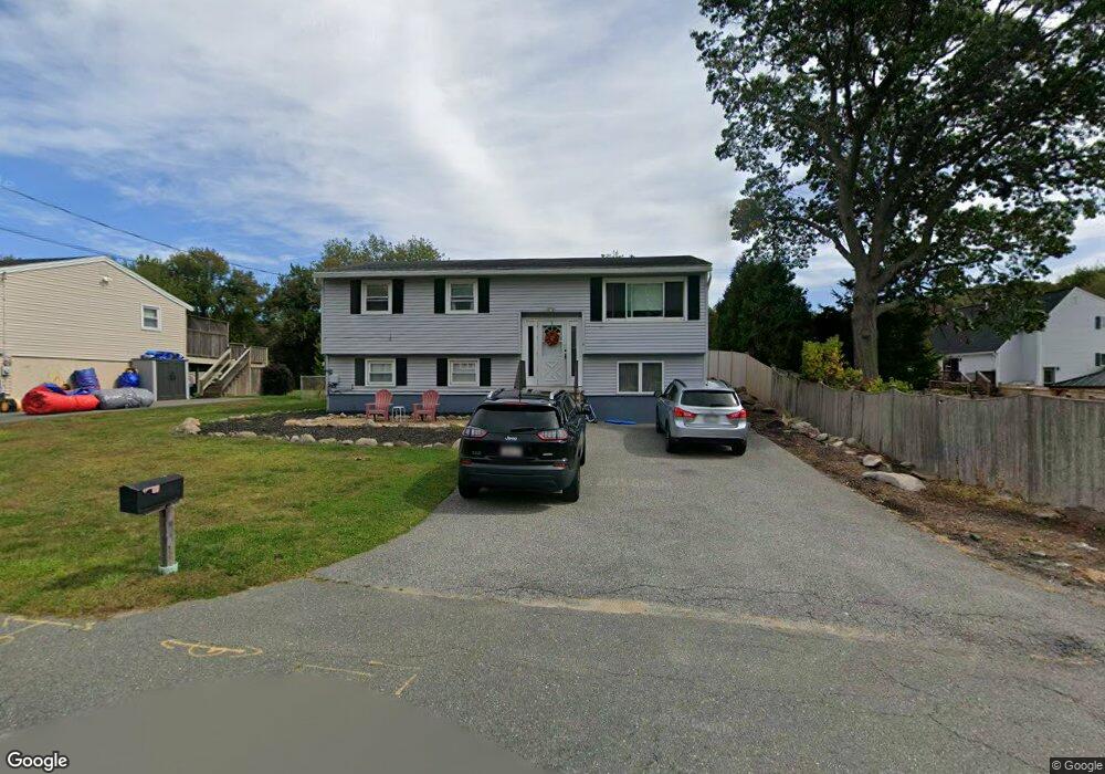
1 Macomber Rd Gloucester, MA 01930
Estimated Value: $636,000 - $715,000
4
Beds
2
Baths
995
Sq Ft
$664/Sq Ft
Est. Value
About This Home
This home is located at 1 Macomber Rd, Gloucester, MA 01930 and is currently estimated at $660,911, approximately $664 per square foot. 1 Macomber Rd is a home located in Essex County with nearby schools including Beeman Memorial, Ralph B O'maley Middle School, and Gloucester High School.
Ownership History
Date
Name
Owned For
Owner Type
Purchase Details
Closed on
Apr 4, 2008
Sold by
Genovese Mary Ann and Genovese Paul R
Bought by
Genovese Paul R J
Current Estimated Value
Purchase Details
Closed on
Sep 23, 2004
Sold by
Genovese Catherine R and Cunningham Grace
Bought by
Genovese Paul R
Purchase Details
Closed on
Feb 4, 2004
Sold by
Genovese Catherine R and Genovese Paul R
Bought by
Cunningham Grace
Purchase Details
Closed on
Aug 1, 1966
Bought by
Genovese Paul R and Genovese Mary Ann
Create a Home Valuation Report for This Property
The Home Valuation Report is an in-depth analysis detailing your home's value as well as a comparison with similar homes in the area
Purchase History
| Date | Buyer | Sale Price | Title Company |
|---|---|---|---|
| Genovese Paul R J | -- | -- | |
| Genovese Paul R | -- | -- | |
| Cunningham Grace | -- | -- | |
| Genovese Paul R | -- | -- |
Source: Public Records
Mortgage History
| Date | Status | Borrower | Loan Amount |
|---|---|---|---|
| Open | Genovese Paul R | $243,000 | |
| Closed | Genovese Paul R | $240,000 |
Source: Public Records
Tax History
| Year | Tax Paid | Tax Assessment Tax Assessment Total Assessment is a certain percentage of the fair market value that is determined by local assessors to be the total taxable value of land and additions on the property. | Land | Improvement |
|---|---|---|---|---|
| 2025 | $5,120 | $526,700 | $184,900 | $341,800 |
| 2024 | $5,245 | $539,100 | $176,000 | $363,100 |
| 2023 | $4,952 | $467,600 | $157,200 | $310,400 |
| 2022 | $4,626 | $394,400 | $136,700 | $257,700 |
| 2021 | $4,723 | $379,700 | $124,300 | $255,400 |
| 2020 | $4,430 | $359,300 | $124,300 | $235,000 |
| 2019 | $4,462 | $351,600 | $124,300 | $227,300 |
| 2018 | $4,206 | $325,300 | $124,300 | $201,000 |
| 2017 | $3,972 | $301,100 | $118,400 | $182,700 |
| 2016 | $3,941 | $289,600 | $123,500 | $166,100 |
| 2015 | $3,804 | $278,700 | $123,500 | $155,200 |
Source: Public Records
Map
Nearby Homes
- 3 Deacon Farm Ln
- 31 Echo Ave
- 13 Honeysuckle Rd
- 2 Breezy Point Rd
- 672 Washington St
- 13 Mystic Ave
- 8 Mystic Ave
- 98 Maplewood Ave
- 6 Monroe Ct
- 12 Arthur St
- 9 Cleveland Place
- 40 Sargent St
- 19 Trask St Unit 2
- 50 Warner St
- 113 Pleasant St
- 33 Maplewood Ave Unit 310
- 15 Mount Vernon St
- 15 Harvard St
- 167 Atlantic St
- 178 Atlantic St
Your Personal Tour Guide
Ask me questions while you tour the home.