Estimated Value: $505,024 - $590,000
4
Beds
2
Baths
2,292
Sq Ft
$242/Sq Ft
Est. Value
About This Home
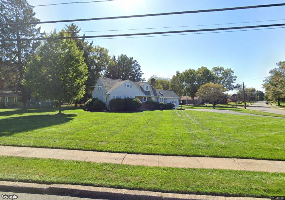
This home is located at 1 Mansfield Rd, Ewing, NJ 08628 and is currently estimated at $555,256, approximately $242 per square foot. 1 Mansfield Rd is a home located in Mercer County with nearby schools including Ewing High School, The Village Charter School, and The Titusville Academy.
Ownership History
Date
Name
Owned For
Owner Type
Purchase Details
Closed on
Nov 11, 2020
Sold by
Cubberley William L and Cubberley Diane B
Bought by
George Michael T and Anene Michele M
Current Estimated Value
Home Financials for this Owner
Home Financials are based on the most recent Mortgage that was taken out on this home.
Original Mortgage
$327,750
Outstanding Balance
$290,317
Interest Rate
2.8%
Mortgage Type
New Conventional
Estimated Equity
$264,939
Purchase Details
Closed on
Oct 24, 1988
Sold by
Rottkamp Jr Robert B and Rottkamp Judith
Bought by
Cubberley William L and Cubberley Diane
Create a Home Valuation Report for This Property
The Home Valuation Report is an in-depth analysis detailing your home's value as well as a comparison with similar homes in the area
Home Values in the Area
Average Home Value in this Area
Purchase History
| Date | Buyer | Sale Price | Title Company |
|---|---|---|---|
| George Michael T | $345,000 | Abco Of Northampton Llc | |
| Cubberley William L | $198,500 | -- |
Source: Public Records
Mortgage History
| Date | Status | Borrower | Loan Amount |
|---|---|---|---|
| Open | George Michael T | $327,750 |
Source: Public Records
Tax History Compared to Growth
Tax History
| Year | Tax Paid | Tax Assessment Tax Assessment Total Assessment is a certain percentage of the fair market value that is determined by local assessors to be the total taxable value of land and additions on the property. | Land | Improvement |
|---|---|---|---|---|
| 2025 | $10,914 | $277,500 | $94,400 | $183,100 |
| 2024 | $10,259 | $277,500 | $94,400 | $183,100 |
| 2023 | $10,259 | $277,500 | $94,400 | $183,100 |
| 2022 | $9,982 | $277,500 | $94,400 | $183,100 |
| 2021 | $9,737 | $277,500 | $94,400 | $183,100 |
| 2020 | $9,599 | $277,500 | $94,400 | $183,100 |
| 2019 | $9,349 | $277,500 | $94,400 | $183,100 |
| 2018 | $10,347 | $195,900 | $69,600 | $126,300 |
| 2017 | $10,588 | $195,900 | $69,600 | $126,300 |
| 2016 | $10,445 | $195,900 | $69,600 | $126,300 |
| 2015 | $10,306 | $195,900 | $69,600 | $126,300 |
| 2014 | $10,279 | $195,900 | $69,600 | $126,300 |
Source: Public Records
Map
Nearby Homes
- 14 Revere Ct
- 18 Pioneer Ct
- 86 Jacobs Creek Rd
- 18 Forrest Blend Dr
- 2 Devonshire Ct
- 28 Delaware Ave
- 18 Todd Ridge Rd
- 20 Delaware Ave
- 8 High Acres Dr
- 8 Beckett Ct
- 230 Jacobs Creek Rd
- 1048 River Rd
- 928 Taylorsville Rd
- 1155 Mount Eyre Rd
- 182 W Upper Ferry Rd
- 46 John Vanzandt Dr
- 44 John Vanzandt Dr
- 202 W Upper Ferry Rd
- 3 Harrison Ave
- 282 Aqueduct Rd
- 7 Lochatong Rd
- 3 Mansfield Rd
- 4 Bedford Dr
- 2 Mansfield Rd
- 9 Lochatong Rd
- 16 Lochatong Rd
- 6 Bedford Dr
- 12 Lochatong Rd
- 14 Lochatong Rd
- 5 Mansfield Rd
- 10 Lochatong Rd
- 4 Mansfield Rd
- 99 Mountainview Rd
- 8 Bedford Dr
- 93 Mountainview Rd
- 8 Lochatong Rd
- 101 Mountainview Rd
- 7 Mansfield Rd
- 3 Bedford Dr
- 1 Bedford Dr