
Seller's Agent in 2025
Pamela Moriarty
Coldwell Banker Realty
(860) 712-0222
147 in this area
401 Total Sales
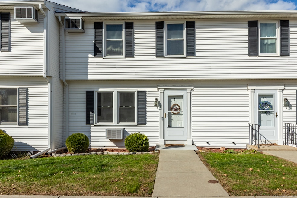
Well-Maintained 960 sq. ft. townhouse-style condo available at Cider Mill Heights! This south facing unit is located in a quiet Ellington complex and includes a large, front-facing Living room with plenty of natural light, an eat-in Kitchen with newer appliances, newer slider (2024) to rear Trex deck, new flooring and a 1/2 bath. The upper level includes 2 large bedrooms and a full bath. The lower level is unfinished but has the potential of adding approximately 400 sq. ft. of potential recreational / living space. The complex is conveniently located close to Ellington Center, Rt. 83, Ellington Senior Center, Ellington High School and Ellington Big Y Supermarket. New windows and slider in 2024. Fresh interior paint and new A/C wall units!
Last Agent to Sell the Property
Coldwell Banker Realty Brokerage Phone: (860) 712-0222 License #RES.0779115 Listed on: 11/07/2025
| Date | Type | Sale Price | Title Company |
|---|---|---|---|
| Warranty Deed | $240,000 | -- | |
| Warranty Deed | $144,000 | -- | |
| Warranty Deed | $101,500 | -- |
| Date | Status | Loan Amount | Loan Type |
|---|---|---|---|
| Open | $192,000 | New Conventional | |
| Previous Owner | $107,855 | Purchase Money Mortgage | |
| Previous Owner | $96,425 | Purchase Money Mortgage |
| Date | Event | Price | List to Sale | Price per Sq Ft |
|---|---|---|---|---|
| 12/19/2025 12/19/25 | Sold | $240,000 | -4.0% | $250 / Sq Ft |
| 11/22/2025 11/22/25 | Pending | -- | -- | -- |
| 11/09/2025 11/09/25 | For Sale | $249,900 | -- | $260 / Sq Ft |
| Year | Tax Paid | Tax Assessment Tax Assessment Total Assessment is a certain percentage of the fair market value that is determined by local assessors to be the total taxable value of land and additions on the property. | Land | Improvement |
|---|---|---|---|---|
| 2025 | $3,017 | $81,330 | $0 | $81,330 |
| 2024 | $2,928 | $81,330 | $0 | $81,330 |
| 2023 | $2,790 | $81,330 | $0 | $81,330 |
| 2022 | $2,643 | $81,330 | $0 | $81,330 |
| 2021 | $2,570 | $81,330 | $0 | $81,330 |
| 2020 | $2,869 | $88,010 | $0 | $88,010 |
| 2019 | $2,869 | $88,010 | $0 | $88,010 |
| 2016 | $2,684 | $88,010 | $0 | $88,010 |
| 2015 | $2,868 | $94,030 | $0 | $94,030 |
| 2014 | $2,699 | $94,030 | $0 | $94,030 |
Seller's Agent in 2025
Pamela Moriarty
Coldwell Banker Realty
(860) 712-0222
147 in this area
401 Total Sales
Buyer's Agent in 2025
Linda Driscoll
Shea & Company Real Estate,LLC
(860) 462-7442
9 in this area
112 Total Sales
Source: SmartMLS
MLS Number: 24120805
APN: ELLI-000073-000011-000021
Disclaimer: Certain information contained herein is derived from information provided by parties other than Homes.com. All information provided is deemed reliable, but is not guaranteed to be accurate and should be independently verified.
![]() IDX information is provided exclusively for personal, non-commercial use, and may not be used for any purpose other than to identify prospective properties consumers may be interested in purchasing. Information is deemed reliable but not guaranteed.
IDX information is provided exclusively for personal, non-commercial use, and may not be used for any purpose other than to identify prospective properties consumers may be interested in purchasing. Information is deemed reliable but not guaranteed.
Ask me questions while you tour the home.