Estimated Value: $882,000 - $985,000
3
Beds
3
Baths
2,414
Sq Ft
$395/Sq Ft
Est. Value
About This Home
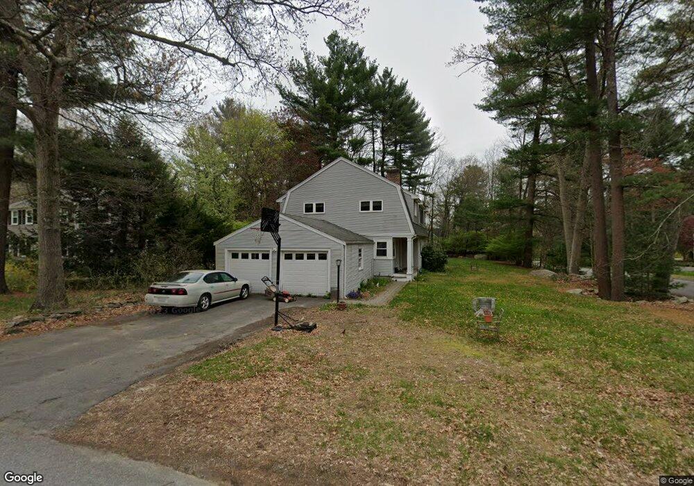
This home is located at 1 Mohegan Rd, Acton, MA 01720 and is currently estimated at $954,127, approximately $395 per square foot. 1 Mohegan Rd is a home located in Middlesex County with nearby schools including Acton-Boxborough Regional High School and Oak Meadow Montessori School.
Ownership History
Date
Name
Owned For
Owner Type
Purchase Details
Closed on
Apr 26, 1990
Sold by
Parker Kenneth C
Bought by
Carotenuto Joseph F
Current Estimated Value
Home Financials for this Owner
Home Financials are based on the most recent Mortgage that was taken out on this home.
Original Mortgage
$154,800
Interest Rate
10.26%
Mortgage Type
Purchase Money Mortgage
Create a Home Valuation Report for This Property
The Home Valuation Report is an in-depth analysis detailing your home's value as well as a comparison with similar homes in the area
Home Values in the Area
Average Home Value in this Area
Purchase History
| Date | Buyer | Sale Price | Title Company |
|---|---|---|---|
| Carotenuto Joseph F | $172,000 | -- |
Source: Public Records
Mortgage History
| Date | Status | Borrower | Loan Amount |
|---|---|---|---|
| Open | Carotenuto Joseph F | $366,000 | |
| Closed | Carotenuto Joseph F | $18,000 | |
| Closed | Carotenuto Joseph F | $154,200 | |
| Closed | Carotenuto Joseph F | $154,800 |
Source: Public Records
Tax History
| Year | Tax Paid | Tax Assessment Tax Assessment Total Assessment is a certain percentage of the fair market value that is determined by local assessors to be the total taxable value of land and additions on the property. | Land | Improvement |
|---|---|---|---|---|
| 2025 | $14,850 | $865,900 | $314,200 | $551,700 |
| 2024 | $13,956 | $837,200 | $314,200 | $523,000 |
| 2023 | $13,623 | $775,800 | $285,500 | $490,300 |
| 2022 | $12,876 | $662,000 | $248,000 | $414,000 |
| 2021 | $12,585 | $622,100 | $229,900 | $392,200 |
| 2020 | $11,863 | $616,600 | $229,900 | $386,700 |
| 2019 | $11,281 | $582,400 | $229,900 | $352,500 |
| 2018 | $11,153 | $575,500 | $229,900 | $345,600 |
| 2017 | $10,862 | $569,900 | $229,900 | $340,000 |
| 2016 | $10,636 | $553,100 | $229,900 | $323,200 |
| 2015 | $9,266 | $486,400 | $229,900 | $256,500 |
| 2014 | $8,978 | $461,600 | $229,900 | $231,700 |
Source: Public Records
Map
Nearby Homes
- 5 Perkins Ln
- 20 Joseph Reed Ln
- 79 Charter Rd
- 60 Nashoba Rd
- 4 Littlefield Rd
- 235 Arlington St
- 18 Hayward Rd
- 246 Main St Unit 2
- 7 Kelley Rd
- 11 Braebrook
- 92 Willow St Unit 3
- 92 Willow St Unit 2
- 90 Willow St Unit 1
- 184 Main St Unit 3
- 4 Omega Way
- 46 Taylor Rd
- 33 Meadowbrook Rd
- 25 Nylander Way
- 491 Main St
- 129 Main St Unit 129
Your Personal Tour Guide
Ask me questions while you tour the home.