R
Seller's Agent in 2025
RachNH Realty Group
Keller Williams Realty-Metropolitan
(978) 494-4989
4 in this area
402 Total Sales
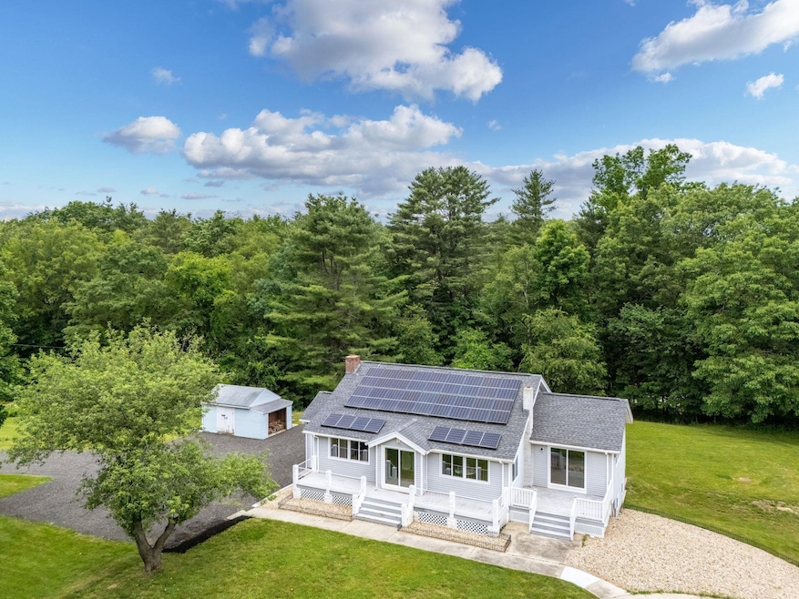
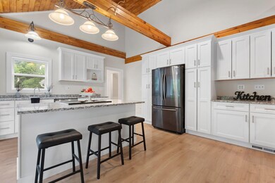
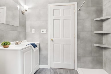
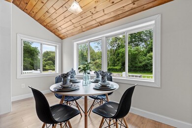
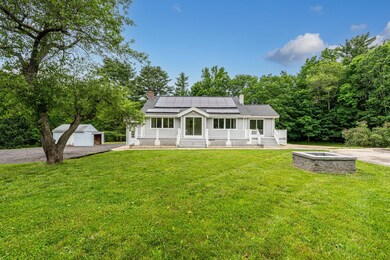
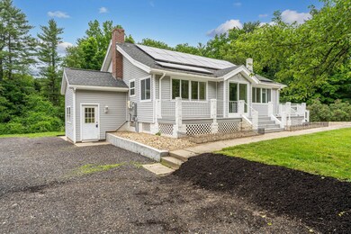
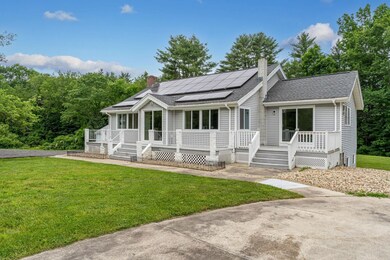
Not a typical 2-unit home! Gorgeous grounds, privacy, quiet, country setting, mature landscaping, solar panels and a complete makeover in 2025! In the last 4 years, the owners have added the solar panels, redone the septic, new HW heater, new windows, new slider, redone the kitchens and bathrooms. The main level offers gorgeous vaulted ceilings and open living between your new kitchen, dining area and living room. You'll love the shiplap and beam detailing to bring charm to the modern design. Easy to maintain vinyl plank flooring is ideal for these high traffic areas. This unit has 3 large bedrooms and a brand new full bathroom. The primary bedroom has a slider to the deck overlooking the great outdoors and an enviable walk in closet! Downstairs the unit is completely remodeled this year. There are 2 bedrooms, a living room with slider, amazingly huge eat-in kitchen and 3/4 bath with W&D. The attention to detail and bright rooms make this home a real showstopper. No Loan on the Solar, just enjoy your remarkably low electricity bill each month. Must see!! Delayed showings until 6/21
Last Agent to Sell the Property
Keller Williams Realty-Metropolitan Listed on: 06/17/2025

| Date | Type | Sale Price | Title Company |
|---|---|---|---|
| Warranty Deed | $650,000 | -- | |
| Warranty Deed | $650,000 | -- | |
| Warranty Deed | $330,000 | None Available | |
| Warranty Deed | $330,000 | None Available |
| Date | Status | Loan Amount | Loan Type |
|---|---|---|---|
| Open | $450,000 | New Conventional | |
| Closed | $450,000 | New Conventional | |
| Previous Owner | $220,000 | Credit Line Revolving | |
| Previous Owner | $264,000 | New Conventional | |
| Previous Owner | $236,000 | Stand Alone Refi Refinance Of Original Loan | |
| Previous Owner | $72,947 | Unknown |
| Date | Event | Price | Change | Sq Ft Price |
|---|---|---|---|---|
| 07/23/2025 07/23/25 | Sold | $650,000 | -3.7% | $446 / Sq Ft |
| 06/17/2025 06/17/25 | For Sale | $675,000 | -- | $463 / Sq Ft |
| Year | Tax Paid | Tax Assessment Tax Assessment Total Assessment is a certain percentage of the fair market value that is determined by local assessors to be the total taxable value of land and additions on the property. | Land | Improvement |
|---|---|---|---|---|
| 2024 | $10,720 | $590,000 | $194,900 | $395,100 |
| 2023 | $9,900 | $529,400 | $179,000 | $350,400 |
| 2022 | $9,634 | $485,600 | $168,500 | $317,100 |
| 2021 | $8,736 | $402,600 | $147,400 | $255,200 |
| 2020 | $8,442 | $339,700 | $126,400 | $213,300 |
| 2019 | $8,315 | $330,100 | $121,100 | $209,000 |
| 2018 | $7,817 | $313,700 | $105,300 | $208,400 |
| 2017 | $7,691 | $297,300 | $94,800 | $202,500 |
| 2016 | $6,917 | $263,100 | $79,000 | $184,100 |
| 2015 | $6,884 | $258,700 | $79,000 | $179,700 |
| 2014 | $6,864 | $263,900 | $84,200 | $179,700 |
| 2011 | $6,370 | $253,600 | $75,800 | $177,800 |
R
Seller's Agent in 2025
RachNH Realty Group
Keller Williams Realty-Metropolitan
(978) 494-4989
4 in this area
402 Total Sales
Buyer's Agent in 2025
Heidi Spencer
Coldwell Banker Realty Portsmouth NH
(603) 828-1270
4 in this area
37 Total Sales
Source: PrimeMLS
MLS Number: 5046957
APN: DOVR-000057-G000000-000001E
Disclaimer: Certain information contained herein is derived from information provided by parties other than Homes.com. All information provided is deemed reliable, but is not guaranteed to be accurate and should be independently verified.
![]() Copyright 2025 PrimeMLS, Inc. All rights reserved. This information is deemed reliable, but not guaranteed. The data relating to real estate displayed on this display comes in part from the IDX Program of PrimeMLS. The information being provided is for consumers’ personal, non-commercial use and may not be used for any purpose other than to identify prospective properties consumers may be interested in purchasing.
Copyright 2025 PrimeMLS, Inc. All rights reserved. This information is deemed reliable, but not guaranteed. The data relating to real estate displayed on this display comes in part from the IDX Program of PrimeMLS. The information being provided is for consumers’ personal, non-commercial use and may not be used for any purpose other than to identify prospective properties consumers may be interested in purchasing.