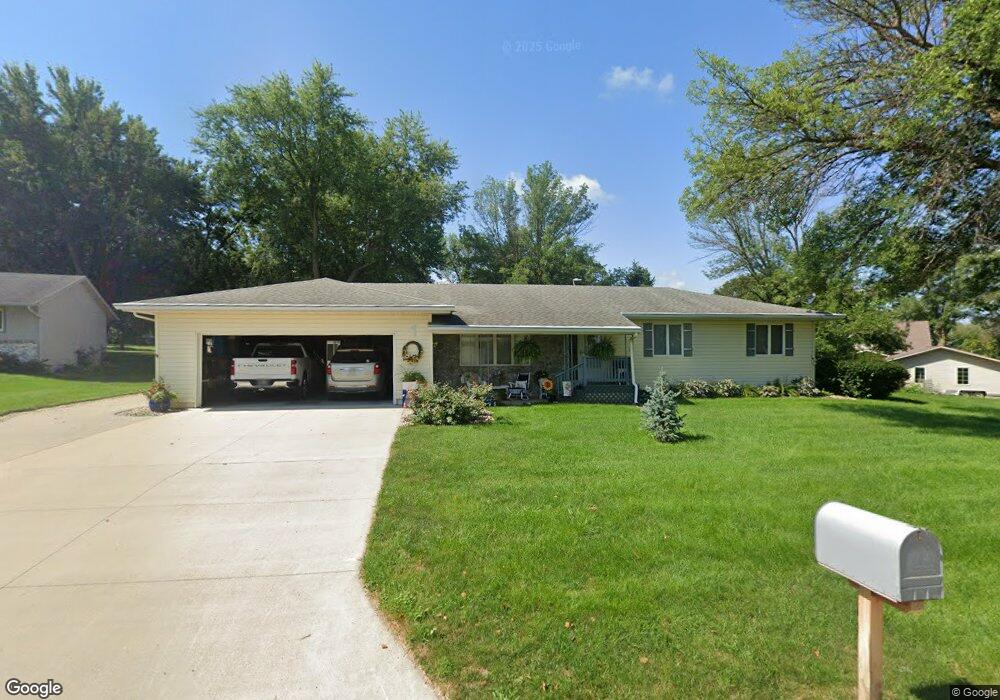
1 Ohm Dr Mapleton, IA 51034
Estimated Value: $232,000 - $266,000
2
Beds
3
Baths
1,518
Sq Ft
$164/Sq Ft
Est. Value
About This Home
This home is located at 1 Ohm Dr, Mapleton, IA 51034 and is currently estimated at $249,072, approximately $164 per square foot. 1 Ohm Dr is a home located in Monona County with nearby schools including Mapleton Elementary School, Mvao Middle School, and Maple Valley-Anthon Oto High School.
Ownership History
Date
Name
Owned For
Owner Type
Purchase Details
Closed on
Oct 27, 2023
Sold by
Leo R Dose And Norma J Dose Evocable Tru
Bought by
Johnson Steven O and Johnson Debra L
Current Estimated Value
Home Financials for this Owner
Home Financials are based on the most recent Mortgage that was taken out on this home.
Original Mortgage
$188,000
Outstanding Balance
$170,771
Interest Rate
6.51%
Mortgage Type
Credit Line Revolving
Estimated Equity
$78,301
Purchase Details
Closed on
Jul 29, 2023
Sold by
Dose Florice Cassens
Bought by
Leo R Dose And Norma J Dose Revocable Trust and Dose
Create a Home Valuation Report for This Property
The Home Valuation Report is an in-depth analysis detailing your home's value as well as a comparison with similar homes in the area
Purchase History
| Date | Buyer | Sale Price | Title Company |
|---|---|---|---|
| Johnson Steven O | $235,500 | None Listed On Document | |
| Leo R Dose And Norma J Dose Revocable Trust | $115,500 | None Listed On Document |
Source: Public Records
Mortgage History
| Date | Status | Borrower | Loan Amount |
|---|---|---|---|
| Open | Johnson Steven O | $188,000 |
Source: Public Records
Tax History
| Year | Tax Paid | Tax Assessment Tax Assessment Total Assessment is a certain percentage of the fair market value that is determined by local assessors to be the total taxable value of land and additions on the property. | Land | Improvement |
|---|---|---|---|---|
| 2024 | $3,096 | $193,224 | $17,640 | $175,584 |
| 2023 | $2,628 | $193,224 | $17,640 | $175,584 |
| 2022 | $1,856 | $153,107 | $0 | $0 |
| 2021 | $1,948 | $123,751 | $18,282 | $105,469 |
| 2020 | $2,280 | $123,751 | $18,282 | $105,469 |
| 2019 | $2,280 | $136,083 | $0 | $0 |
| 2018 | $2,228 | $136,083 | $0 | $0 |
| 2017 | $2,228 | $129,603 | $0 | $0 |
| 2016 | $2,174 | $129,603 | $0 | $0 |
| 2015 | $2,048 | $114,693 | $0 | $0 |
| 2014 | $1,852 | $114,693 | $0 | $0 |
Source: Public Records
Map
Nearby Homes
Your Personal Tour Guide
Ask me questions while you tour the home.