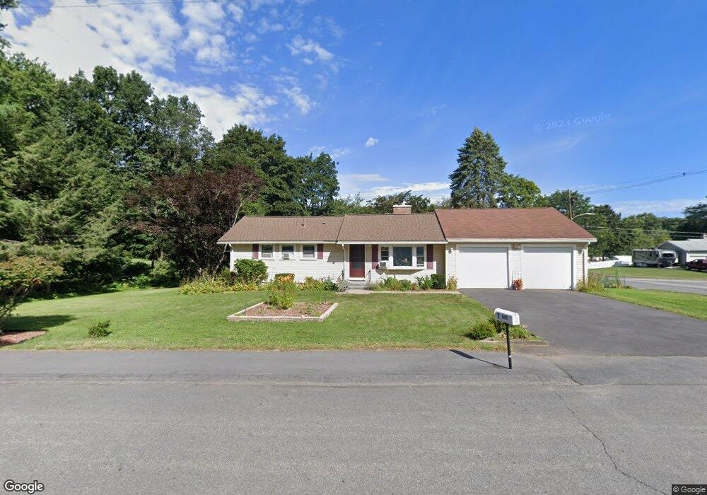
1 Otsego Dr Hudson, MA 01749
Estimated Value: $517,710 - $605,000
3
Beds
1
Bath
989
Sq Ft
$552/Sq Ft
Est. Value
About This Home
This home is located at 1 Otsego Dr, Hudson, MA 01749 and is currently estimated at $545,678, approximately $551 per square foot. 1 Otsego Dr is a home located in Middlesex County with nearby schools including David J. Quinn Middle School, Hudson High School, and First Steps Children's Center.
Ownership History
Date
Name
Owned For
Owner Type
Purchase Details
Closed on
Sep 12, 2016
Sold by
Davis Paul A
Bought by
Davis Paul A and Davis Lynn M
Current Estimated Value
Purchase Details
Closed on
Sep 29, 1995
Sold by
Egan James J and Egan Mildred P
Bought by
Davis Paul A
Home Financials for this Owner
Home Financials are based on the most recent Mortgage that was taken out on this home.
Original Mortgage
$116,900
Interest Rate
7.89%
Mortgage Type
Purchase Money Mortgage
Purchase Details
Closed on
Jun 24, 1991
Sold by
Alin Rt
Bought by
Huru Mary J and Huru John K
Home Financials for this Owner
Home Financials are based on the most recent Mortgage that was taken out on this home.
Original Mortgage
$140,000
Interest Rate
9.37%
Mortgage Type
Purchase Money Mortgage
Create a Home Valuation Report for This Property
The Home Valuation Report is an in-depth analysis detailing your home's value as well as a comparison with similar homes in the area
Home Values in the Area
Average Home Value in this Area
Purchase History
| Date | Buyer | Sale Price | Title Company |
|---|---|---|---|
| Davis Paul A | -- | -- | |
| Davis Paul A | -- | -- | |
| Davis Paul A | $146,900 | -- | |
| Huru Mary J | $209,700 | -- | |
| Huru Mary J | $209,700 | -- |
Source: Public Records
Mortgage History
| Date | Status | Borrower | Loan Amount |
|---|---|---|---|
| Previous Owner | Huru Mary J | $116,900 | |
| Previous Owner | Huru Mary J | $140,000 |
Source: Public Records
Tax History Compared to Growth
Tax History
| Year | Tax Paid | Tax Assessment Tax Assessment Total Assessment is a certain percentage of the fair market value that is determined by local assessors to be the total taxable value of land and additions on the property. | Land | Improvement |
|---|---|---|---|---|
| 2025 | $6,644 | $478,700 | $183,700 | $295,000 |
| 2024 | $6,343 | $453,100 | $166,900 | $286,200 |
| 2023 | $6,065 | $415,400 | $160,500 | $254,900 |
| 2022 | $5,790 | $365,100 | $145,800 | $219,300 |
| 2021 | $5,627 | $339,200 | $138,900 | $200,300 |
| 2020 | $5,285 | $318,200 | $136,200 | $182,000 |
| 2019 | $5,279 | $310,000 | $136,200 | $173,800 |
| 2018 | $5,098 | $291,300 | $129,800 | $161,500 |
| 2017 | $4,776 | $272,900 | $123,600 | $149,300 |
| 2016 | $4,435 | $256,500 | $123,600 | $132,900 |
| 2015 | $4,053 | $234,700 | $123,600 | $111,100 |
| 2014 | $3,996 | $229,400 | $108,300 | $121,100 |
Source: Public Records
Map
Nearby Homes
- 1 Rotherham Way Unit B
- 129 Fort Meadow Dr
- 18 Collins Dr
- 48 Jewell Rd Unit Lot 6
- 46 Jewell Rd Unit Lot 5
- 44 Jewell Rd Unit Lot 4
- 30 Jewell Rd Unit Lot 2
- 36 Jewell Rd Unit Lot 3
- 2 Blueberry Ln
- 3 Townsend Rd
- 44 Stevens Rd
- 56 Forest Ave
- 57 Paquin Dr
- 34 Woodrow St
- 0 Washington St
- 18 Amory Rd
- 243 Washington St
- 8 Abigail Dr
- 9 & 9A Abigail
- 135 Broad St Unit 2B3