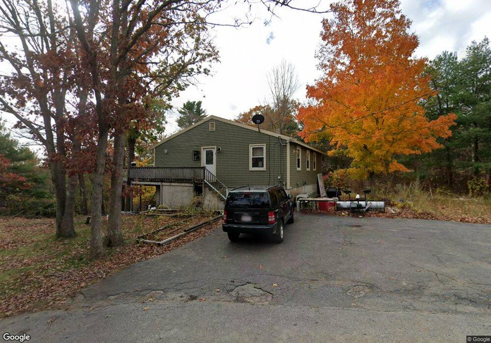
1 Whites Mountain Rd Gloucester, MA 01930
West Gloucester NeighborhoodEstimated Value: $627,000 - $790,000
3
Beds
1
Bath
1,152
Sq Ft
$588/Sq Ft
Est. Value
About This Home
This home is located at 1 Whites Mountain Rd, Gloucester, MA 01930 and is currently estimated at $677,778, approximately $588 per square foot. 1 Whites Mountain Rd is a home located in Essex County with nearby schools including West Parish, Ralph B O'maley Middle School, and Gloucester High School.
Ownership History
Date
Name
Owned For
Owner Type
Purchase Details
Closed on
May 14, 2024
Sold by
Smith Donald E and Smith Teresa M
Bought by
One Wmr Rt and Smith
Current Estimated Value
Purchase Details
Closed on
Nov 24, 2020
Sold by
Breaker Megan E and Smith Teresa M
Bought by
Smith Donald E and Smith Teresa M
Purchase Details
Closed on
Jan 12, 2010
Sold by
Poulsen Cynthia L and Ganley Jeanne S
Bought by
Smith Donald E
Home Financials for this Owner
Home Financials are based on the most recent Mortgage that was taken out on this home.
Original Mortgage
$390,000
Interest Rate
4.78%
Mortgage Type
Purchase Money Mortgage
Purchase Details
Closed on
Sep 14, 2007
Sold by
White E Barbara
Bought by
Secrest Carole M
Purchase Details
Closed on
Mar 4, 2005
Sold by
White E Barbara and White Ethel
Bought by
White David A
Create a Home Valuation Report for This Property
The Home Valuation Report is an in-depth analysis detailing your home's value as well as a comparison with similar homes in the area
Home Values in the Area
Average Home Value in this Area
Purchase History
| Date | Buyer | Sale Price | Title Company |
|---|---|---|---|
| One Wmr Rt | -- | None Available | |
| One Wmr Rt | -- | None Available | |
| Smith Donald E | -- | None Available | |
| Smith Donald E | -- | None Available | |
| Breaker Megan E | -- | None Available | |
| Smith Donald E | -- | None Available | |
| Breaker Megan E | -- | None Available | |
| Smith Donald E | $180,000 | -- | |
| Smith Donald E | $180,000 | -- | |
| Secrest Carole M | -- | -- | |
| Secrest Carole M | -- | -- | |
| White David A | -- | -- | |
| White David A | -- | -- |
Source: Public Records
Mortgage History
| Date | Status | Borrower | Loan Amount |
|---|---|---|---|
| Previous Owner | White David A | $390,000 |
Source: Public Records
Tax History
| Year | Tax Paid | Tax Assessment Tax Assessment Total Assessment is a certain percentage of the fair market value that is determined by local assessors to be the total taxable value of land and additions on the property. | Land | Improvement |
|---|---|---|---|---|
| 2025 | $5,246 | $539,700 | $223,200 | $316,500 |
| 2024 | $4,985 | $512,300 | $212,500 | $299,800 |
| 2023 | $4,964 | $468,700 | $189,700 | $279,000 |
| 2022 | $4,507 | $384,200 | $165,000 | $219,200 |
| 2021 | $4,512 | $362,700 | $150,100 | $212,600 |
| 2020 | $4,253 | $344,900 | $150,100 | $194,800 |
| 2019 | $4,077 | $321,300 | $141,000 | $180,300 |
| 2018 | $4,008 | $310,000 | $141,000 | $169,000 |
| 2017 | $3,900 | $295,700 | $134,300 | $161,400 |
| 2016 | $3,763 | $276,500 | $140,000 | $136,500 |
| 2015 | $3,698 | $270,900 | $140,000 | $130,900 |
Source: Public Records
Map
Nearby Homes
- 368 Essex Ave
- 5 Samoset Rd Unit B
- 7 Leaman Dr
- 5 Lepage Ln
- 587 Essex Ave
- 24 Cobblestone Ln Unit 603
- 145 Essex Ave Unit 402
- 167 Atlantic St
- 178 Atlantic St
- 13 Honeysuckle Rd
- 15 Lufkin Point Rd
- 226 Atlantic St
- 3 Rockland St
- 2 Breezy Point Rd
- 3 Deacon Farm Ln
- 31 Echo Ave
- 5 Marshfield St
- 15 Harvard St
- 6 Monroe Ct
- 13 Leslie o Johnson Rd
Your Personal Tour Guide
Ask me questions while you tour the home.