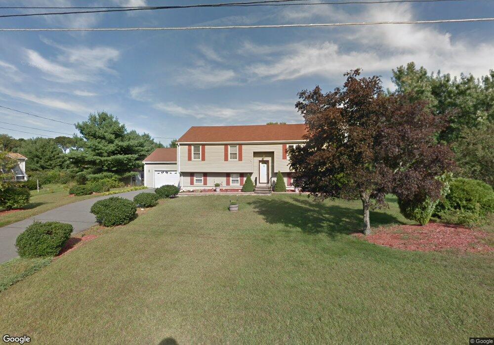
10 Aldis Ln Wrentham, MA 02093
Estimated Value: $617,000 - $694,000
3
Beds
2
Baths
1,900
Sq Ft
$353/Sq Ft
Est. Value
About This Home
This home is located at 10 Aldis Ln, Wrentham, MA 02093 and is currently estimated at $670,042, approximately $352 per square foot. 10 Aldis Ln is a home located in Norfolk County with nearby schools including Delaney Elementary School and Charles E Roderick.
Ownership History
Date
Name
Owned For
Owner Type
Purchase Details
Closed on
Jun 9, 2014
Sold by
Rutkowski Harriet
Bought by
Welch Christopher and Welch Cheryl A
Current Estimated Value
Home Financials for this Owner
Home Financials are based on the most recent Mortgage that was taken out on this home.
Original Mortgage
$304,000
Outstanding Balance
$231,684
Interest Rate
4.33%
Mortgage Type
New Conventional
Estimated Equity
$438,358
Purchase Details
Closed on
Jul 16, 1997
Sold by
Burke William G and Burke Leesa W
Bought by
Rutkowksi George and Rutkowski Harriet
Home Financials for this Owner
Home Financials are based on the most recent Mortgage that was taken out on this home.
Original Mortgage
$30,000
Interest Rate
7.79%
Mortgage Type
Purchase Money Mortgage
Create a Home Valuation Report for This Property
The Home Valuation Report is an in-depth analysis detailing your home's value as well as a comparison with similar homes in the area
Home Values in the Area
Average Home Value in this Area
Purchase History
| Date | Buyer | Sale Price | Title Company |
|---|---|---|---|
| Welch Christopher | $320,000 | -- | |
| Rutkowksi George | $183,000 | -- |
Source: Public Records
Mortgage History
| Date | Status | Borrower | Loan Amount |
|---|---|---|---|
| Open | Welch Christopher | $304,000 | |
| Previous Owner | Rutkowksi George | $30,000 | |
| Previous Owner | Rutkowksi George | $74,000 | |
| Previous Owner | Rutkowksi George | $72,000 |
Source: Public Records
Tax History Compared to Growth
Tax History
| Year | Tax Paid | Tax Assessment Tax Assessment Total Assessment is a certain percentage of the fair market value that is determined by local assessors to be the total taxable value of land and additions on the property. | Land | Improvement |
|---|---|---|---|---|
| 2025 | $6,784 | $585,300 | $289,200 | $296,100 |
| 2024 | $6,424 | $535,300 | $289,200 | $246,100 |
| 2023 | $5,541 | $439,100 | $263,000 | $176,100 |
| 2022 | $5,489 | $401,500 | $245,400 | $156,100 |
| 2021 | $4,682 | $332,800 | $214,200 | $118,600 |
| 2020 | $5,153 | $361,600 | $190,500 | $171,100 |
| 2019 | $4,702 | $333,000 | $190,500 | $142,500 |
| 2018 | $4,941 | $347,000 | $190,600 | $156,400 |
| 2017 | $4,658 | $326,900 | $186,900 | $140,000 |
| 2016 | $4,554 | $318,900 | $181,500 | $137,400 |
| 2015 | $4,445 | $296,700 | $174,500 | $122,200 |
| 2014 | $4,373 | $285,600 | $167,800 | $117,800 |
Source: Public Records
Map
Nearby Homes
- 246 Forest Grove Ave
- 270 Dedham St
- 570 Franklin St
- 10 Nature View Dr
- 15 Nature View Dr
- 45 Joshua Rd
- 50 Reed Fulton Ave Unit Lot 61
- 1 Lorraine Metcalf Dr
- 3 Oak Rd
- 0 W Birch Rd
- 10 W Birch Rd
- 45 King St
- 131 Creek St Unit 7
- 3 Sparrow Rd
- 362 East St
- 11 Earle Stewart Ln
- 38 Robin Rd
- Lot 3 - 14 Earle Stewart Ln
- 11 Quail Run Rd
- 14 Essex St