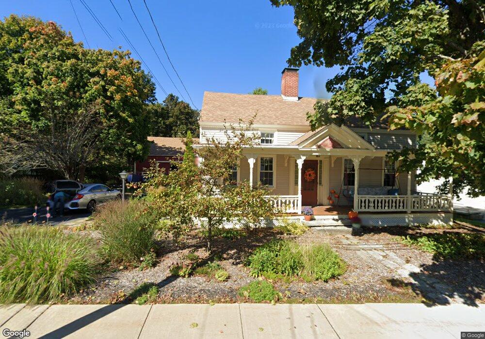
10 Bacon St Westminster, MA 01473
Estimated Value: $514,001 - $626,000
3
Beds
2
Baths
1,922
Sq Ft
$289/Sq Ft
Est. Value
About This Home
This home is located at 10 Bacon St, Westminster, MA 01473 and is currently estimated at $555,250, approximately $288 per square foot. 10 Bacon St is a home located in Worcester County with nearby schools including Oakmont Regional High School and Wachusett Hills Christian School.
Ownership History
Date
Name
Owned For
Owner Type
Purchase Details
Closed on
May 22, 2025
Sold by
Zibailo Ellen A
Bought by
Ellen A Zibailo Ret and Zibailo
Current Estimated Value
Purchase Details
Closed on
Aug 13, 2010
Sold by
Lupien Bonnie P
Bought by
Zibailo Ellen A
Purchase Details
Closed on
Jun 30, 2010
Sold by
Zibailo Ellen A and Lupien Bonnie P
Bought by
Lupien Bonnie P and Zibailo Ellen A
Create a Home Valuation Report for This Property
The Home Valuation Report is an in-depth analysis detailing your home's value as well as a comparison with similar homes in the area
Home Values in the Area
Average Home Value in this Area
Purchase History
| Date | Buyer | Sale Price | Title Company |
|---|---|---|---|
| Ellen A Zibailo Ret | -- | None Available | |
| Ellen A Zibailo Ret | -- | None Available | |
| Zibailo Ellen A | $88,714 | -- | |
| Zibailo Ellen A | $88,714 | -- | |
| Lupien Bonnie P | $175,000 | -- | |
| Lupien Bonnie P | $175,000 | -- | |
| Lupien Bonnie P | $175,000 | -- |
Source: Public Records
Tax History Compared to Growth
Tax History
| Year | Tax Paid | Tax Assessment Tax Assessment Total Assessment is a certain percentage of the fair market value that is determined by local assessors to be the total taxable value of land and additions on the property. | Land | Improvement |
|---|---|---|---|---|
| 2025 | $4,867 | $395,700 | $110,000 | $285,700 |
| 2024 | $4,643 | $378,700 | $110,000 | $268,700 |
| 2023 | $4,636 | $355,000 | $102,800 | $252,200 |
| 2022 | $4,546 | $287,700 | $89,300 | $198,400 |
| 2021 | $4,373 | $260,900 | $71,100 | $189,800 |
| 2020 | $4,465 | $254,400 | $64,600 | $189,800 |
| 2019 | $4,437 | $243,100 | $53,300 | $189,800 |
| 2018 | $3,847 | $207,400 | $56,300 | $151,100 |
| 2017 | $3,603 | $198,100 | $50,300 | $147,800 |
| 2016 | $3,474 | $185,000 | $42,000 | $143,000 |
| 2015 | $3,506 | $185,000 | $42,000 | $143,000 |
| 2014 | $3,511 | $185,000 | $42,000 | $143,000 |
Source: Public Records
Map
Nearby Homes
- 13 Elliott St
- 17 Leominster St
- 4 Tandem Dr
- 45 Bacon St
- 0 Worcester Rd Unit 73326124
- 26 W Main St
- 2 Old Town Farm Rd
- Lot A Frog Hollow Rd
- 51 State Rd E
- 73 N Common Rd
- 240-Lot 2 Davis Rd
- 25 Newcomb Rd
- 0 Syd Smith Rd Unit 73395578
- 0 Syd Smith Rd (Rear)
- 0 Syd Smith Rd (Parcel 71 4 1)
- 100A W Main St
- 47 Newcomb Rd
- 21 Davis Rd
- 11 Syd Smith Rd
- 22 Heritage Ln