Estimated Value: $442,000 - $527,000
3
Beds
2
Baths
2,132
Sq Ft
$236/Sq Ft
Est. Value
About This Home
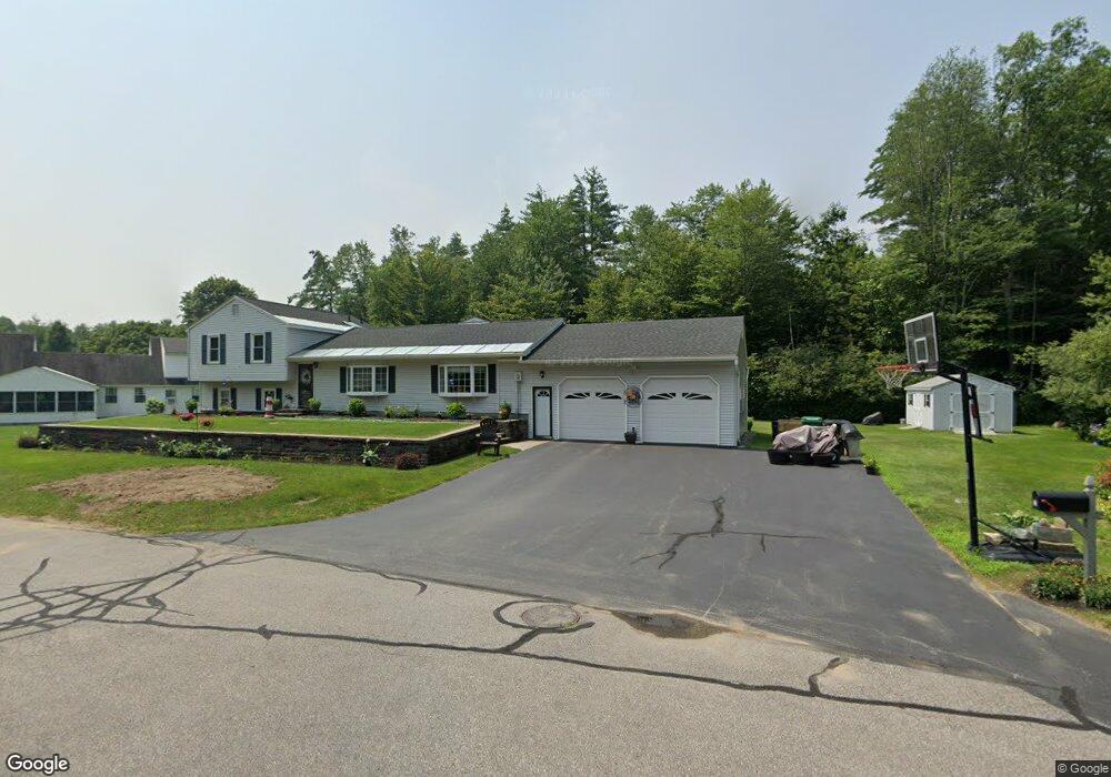
This home is located at 10 Benton Rd, Keene, NH 03431 and is currently estimated at $503,533, approximately $236 per square foot. 10 Benton Rd is a home with nearby schools including Mount Gilead Elementary School, Symonds Elementary School, and Keene Middle School.
Ownership History
Date
Name
Owned For
Owner Type
Purchase Details
Closed on
Sep 25, 2024
Sold by
Korpi Michael L
Bought by
Korpi Sherilyn M
Current Estimated Value
Purchase Details
Closed on
Dec 15, 2022
Sold by
Korpi Michael L
Bought by
Korpi Michael L and Korpi Sherilyn M
Purchase Details
Closed on
Jul 11, 1996
Sold by
Korpi Leonard F
Bought by
Korpi Michael L
Home Financials for this Owner
Home Financials are based on the most recent Mortgage that was taken out on this home.
Original Mortgage
$140,000
Interest Rate
7.98%
Create a Home Valuation Report for This Property
The Home Valuation Report is an in-depth analysis detailing your home's value as well as a comparison with similar homes in the area
Home Values in the Area
Average Home Value in this Area
Purchase History
| Date | Buyer | Sale Price | Title Company |
|---|---|---|---|
| Korpi Sherilyn M | -- | None Available | |
| Korpi Sherilyn M | -- | None Available | |
| Korpi Michael L | -- | None Available | |
| Korpi Michael L | -- | None Available | |
| Korpi Michael L | $175,000 | -- | |
| Korpi Michael L | $175,000 | -- |
Source: Public Records
Mortgage History
| Date | Status | Borrower | Loan Amount |
|---|---|---|---|
| Previous Owner | Korpi Michael L | $140,000 |
Source: Public Records
Tax History Compared to Growth
Tax History
| Year | Tax Paid | Tax Assessment Tax Assessment Total Assessment is a certain percentage of the fair market value that is determined by local assessors to be the total taxable value of land and additions on the property. | Land | Improvement |
|---|---|---|---|---|
| 2024 | $10,715 | $324,000 | $58,500 | $265,500 |
| 2023 | $10,332 | $324,000 | $58,500 | $265,500 |
| 2022 | $10,054 | $324,000 | $58,500 | $265,500 |
| 2021 | $10,044 | $321,100 | $58,500 | $262,600 |
| 2020 | $10,699 | $287,000 | $68,400 | $218,600 |
| 2019 | $10,791 | $287,000 | $68,400 | $218,600 |
| 2018 | $10,653 | $287,000 | $68,400 | $218,600 |
| 2017 | $10,712 | $287,800 | $69,200 | $218,600 |
| 2016 | $10,473 | $287,800 | $69,200 | $218,600 |
| 2015 | $10,994 | $319,500 | $77,300 | $242,200 |
Source: Public Records
Map
Nearby Homes
- 18 Stanton Ct
- 45 Blossom St
- 23 Base Hill Rd
- 7 Newman St
- 257 Park Ave
- 110 Arch St Unit 27
- 110 Arch St Unit 42
- 89 Kendall Rd
- 220 Hurricane Rd
- 316 Perk St
- 23 Schult St
- 25 Schult St
- 28 Stonehouse Ln
- 38 Stonehouse Ln Unit A
- 232 Winchester St
- 32a Stonehouse Ln
- 67 Woodburn St
- 238 Base Hill Rd Unit A12
- 50 Forest St
- 0 Stevens St Unit 1
- 33 Greenbriar Rd
- 11 Benton Rd
- 5 Benton Rd
- 20 Benton Rd
- 45 Greenbriar Rd
- 21 Greenbriar Rd
- 30 Greenbriar Rd
- 12 Salisbury Rd
- 16 Salisbury Rd
- 8 Salisbury Rd
- 20 Salisbury Rd
- 17 Greenbriar Rd
- 24 Greenbriar Rd
- 83 Ridgewood Ave
- 24 Salisbury Rd
- 91 Ridgewood Ave
- 20 Greenbriar Rd
- 51 Greenbriar Rd
- 79 Ridgewood Ave
- 11 Salisbury Rd