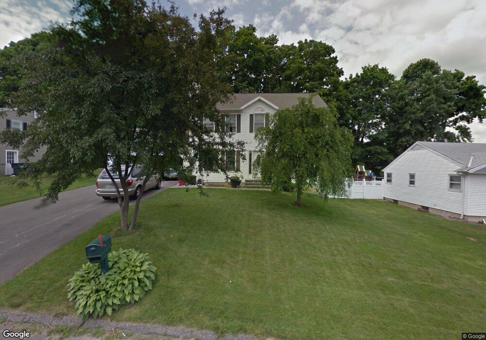
10 Birch Meadow Dr Watertown, CT 06795
Estimated Value: $374,000 - $481,000
3
Beds
3
Baths
1,768
Sq Ft
$247/Sq Ft
Est. Value
About This Home
This home is located at 10 Birch Meadow Dr, Watertown, CT 06795 and is currently estimated at $436,442, approximately $246 per square foot. 10 Birch Meadow Dr is a home located in Litchfield County with nearby schools including John Trumbull Primary School, Swift Middle School, and Watertown High School.
Ownership History
Date
Name
Owned For
Owner Type
Purchase Details
Closed on
Apr 30, 2019
Sold by
Desimone Antonio
Bought by
Desimone Antonio and Desimone Tara
Current Estimated Value
Home Financials for this Owner
Home Financials are based on the most recent Mortgage that was taken out on this home.
Original Mortgage
$142,500
Outstanding Balance
$124,510
Interest Rate
4%
Mortgage Type
New Conventional
Estimated Equity
$311,932
Purchase Details
Closed on
Sep 6, 2000
Sold by
Zenuni Zenan and Zenuni Femi
Bought by
Desimone Antonio
Home Financials for this Owner
Home Financials are based on the most recent Mortgage that was taken out on this home.
Original Mortgage
$95,000
Interest Rate
8.1%
Mortgage Type
Purchase Money Mortgage
Create a Home Valuation Report for This Property
The Home Valuation Report is an in-depth analysis detailing your home's value as well as a comparison with similar homes in the area
Home Values in the Area
Average Home Value in this Area
Purchase History
| Date | Buyer | Sale Price | Title Company |
|---|---|---|---|
| Desimone Antonio | -- | -- | |
| Desimone Antonio | $198,000 | -- |
Source: Public Records
Mortgage History
| Date | Status | Borrower | Loan Amount |
|---|---|---|---|
| Open | Desimone Antonio | $142,500 | |
| Previous Owner | Desimone Antonio | $120,000 | |
| Previous Owner | Desimone Antonio | $99,000 | |
| Previous Owner | Desimone Antonio | $97,500 | |
| Previous Owner | Desimone Antonio | $95,000 |
Source: Public Records
Tax History Compared to Growth
Tax History
| Year | Tax Paid | Tax Assessment Tax Assessment Total Assessment is a certain percentage of the fair market value that is determined by local assessors to be the total taxable value of land and additions on the property. | Land | Improvement |
|---|---|---|---|---|
| 2025 | $7,135 | $237,510 | $49,070 | $188,440 |
| 2024 | $6,738 | $237,510 | $49,070 | $188,440 |
| 2023 | $6,771 | $183,700 | $47,300 | $136,400 |
| 2022 | $6,418 | $183,700 | $47,300 | $136,400 |
| 2021 | $6,349 | $183,700 | $47,300 | $136,400 |
| 2020 | $6,097 | $183,700 | $47,300 | $136,400 |
| 2019 | $6,097 | $183,700 | $47,300 | $136,400 |
| 2018 | $5,798 | $172,600 | $52,000 | $120,600 |
| 2017 | $5,502 | $172,600 | $52,000 | $120,600 |
| 2016 | $5,332 | $172,600 | $52,000 | $120,600 |
| 2015 | $5,195 | $172,600 | $52,000 | $120,600 |
| 2014 | $5,026 | $172,600 | $52,000 | $120,600 |
Source: Public Records
Map
Nearby Homes
- 47 Westview Dr
- 278 Georgetown Dr
- 134 Plainfield Dr
- 43 Woodvine Ave
- 73 Pullen Ave
- 180 Williamson Cir
- 167 Bamford Ave
- 0 Bamford Ave
- 134 Heritage Dr
- 120 Williamson Cir
- 24 Park Ln
- 107 Angel Dr Unit B
- 60 Mason Ave
- 98 Angel Dr
- 859 Bunker Hill Ave
- 227 Morro St
- 76 Kenmore Ave
- 250 Morro St
- 22 Merrimac St
- 32 Clough Rd
- 20 Birch Meadow Dr
- 80 Bunker Hill Rd
- 28 Birch Meadow Dr
- 92 Bunker Hill Rd
- 17 Birch Meadow Dr
- 25 Birch Meadow Dr
- 36 Birch Meadow Dr
- 100 Bunker Hill Rd
- 81 Bunker Hill Rd
- 71 Bunker Hill Rd
- 33 Birch Meadow Dr
- 87 Bunker Hill Rd
- 18 Sprucewood Rd
- 44 Birch Meadow Dr
- 61 Bunker Hill Rd
- 26 Sprucewood Rd
- 118 Bunker Hill Rd
- 41 Birch Meadow Dr
- 101 Bunker Hill Rd
- 34 Sprucewood Rd