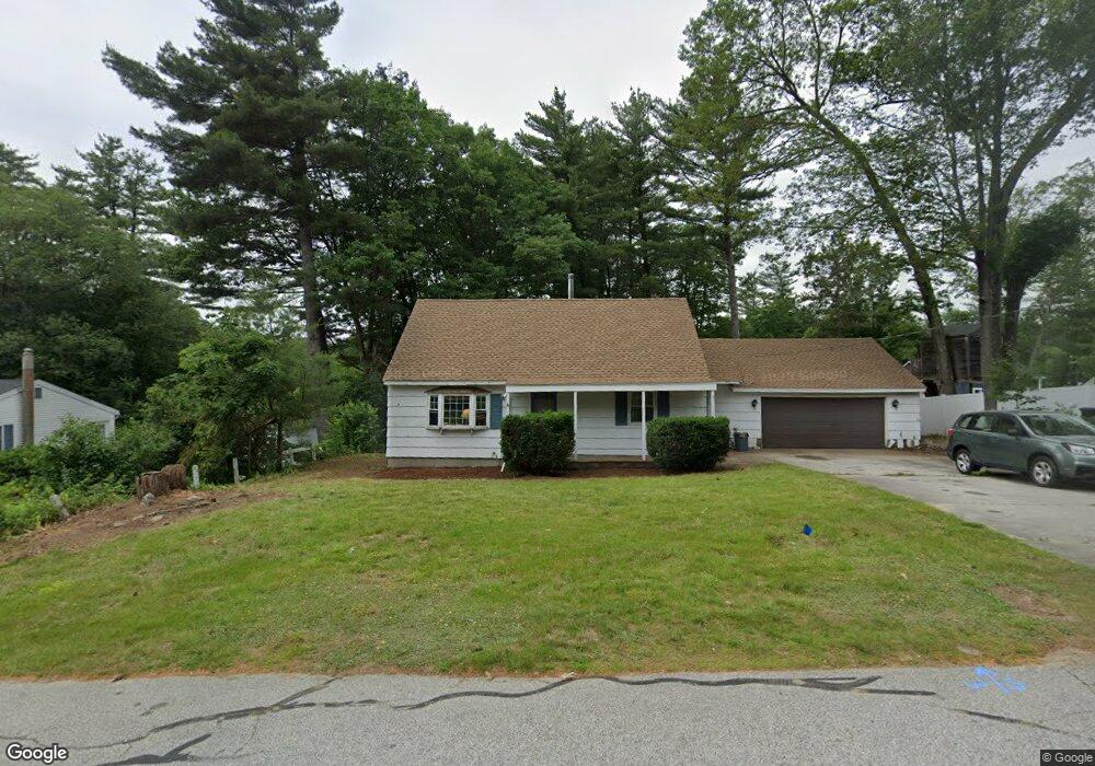
10 Bradford Dr Merrimack, NH 03054
Estimated Value: $458,921 - $533,000
3
Beds
2
Baths
2,030
Sq Ft
$242/Sq Ft
Est. Value
About This Home
This home is located at 10 Bradford Dr, Merrimack, NH 03054 and is currently estimated at $492,230, approximately $242 per square foot. 10 Bradford Dr is a home located in Hillsborough County with nearby schools including Reeds Ferry School, James Mastricola Upper Elementary School, and Merrimack Middle School.
Ownership History
Date
Name
Owned For
Owner Type
Purchase Details
Closed on
Feb 6, 2018
Sold by
Avital Raphael and Avital Kathie S
Bought by
Avital Raphael
Current Estimated Value
Purchase Details
Closed on
Mar 2, 1998
Sold by
Lena Rita C
Bought by
Avitol Raphael and Avitol Kathie S
Home Financials for this Owner
Home Financials are based on the most recent Mortgage that was taken out on this home.
Original Mortgage
$110,021
Interest Rate
6.85%
Purchase Details
Closed on
Mar 21, 1996
Sold by
Purba Alian S and Purba Susan
Bought by
Floyd Jayson M L and Floyd Denise M
Home Financials for this Owner
Home Financials are based on the most recent Mortgage that was taken out on this home.
Original Mortgage
$81,600
Interest Rate
6.99%
Create a Home Valuation Report for This Property
The Home Valuation Report is an in-depth analysis detailing your home's value as well as a comparison with similar homes in the area
Home Values in the Area
Average Home Value in this Area
Purchase History
| Date | Buyer | Sale Price | Title Company |
|---|---|---|---|
| Avital Raphael | -- | -- | |
| Avitol Raphael | $110,000 | -- | |
| Floyd Jayson M L | $80,000 | -- |
Source: Public Records
Mortgage History
| Date | Status | Borrower | Loan Amount |
|---|---|---|---|
| Previous Owner | Floyd Jayson M L | $65,000 | |
| Previous Owner | Floyd Jayson M L | $110,021 | |
| Previous Owner | Floyd Jayson M L | $81,600 |
Source: Public Records
Tax History Compared to Growth
Tax History
| Year | Tax Paid | Tax Assessment Tax Assessment Total Assessment is a certain percentage of the fair market value that is determined by local assessors to be the total taxable value of land and additions on the property. | Land | Improvement |
|---|---|---|---|---|
| 2024 | $6,573 | $317,700 | $186,700 | $131,000 |
| 2023 | $6,179 | $317,700 | $186,700 | $131,000 |
| 2022 | $5,522 | $317,700 | $186,700 | $131,000 |
| 2021 | $5,455 | $317,700 | $186,700 | $131,000 |
| 2020 | $5,428 | $225,600 | $124,900 | $100,700 |
| 2019 | $5,444 | $225,600 | $124,900 | $100,700 |
| 2018 | $5,441 | $225,600 | $124,900 | $100,700 |
| 2017 | $5,403 | $231,200 | $124,900 | $106,300 |
| 2016 | $5,269 | $231,200 | $124,900 | $106,300 |
| 2015 | $5,248 | $212,300 | $113,700 | $98,600 |
| 2014 | $5,114 | $212,300 | $113,700 | $98,600 |
| 2013 | $5,076 | $212,300 | $113,700 | $98,600 |
Source: Public Records
Map
Nearby Homes
- 29 Bedford Rd
- 22 Kimberly Dr
- 1 Pleasant St
- 19 Vista Way
- 490 Charles Bancroft Hwy
- 38 Mallard Point
- 9 Mustang Dr Unit C
- 9 Mustang Dr Unit B
- 7 Mustang Dr Unit C
- 7 Mustang Dr Unit END UNIT-A
- 10 Kingston Ct Unit 10
- 11 Essex Green Ct
- 22 Essex Green Ct
- 12 Clinton Ct
- 5 Barbie Ct
- 3-C Mustang Dr Unit MODEL
- 31 Garden Dr
- 22 Clay St
- 25 Chatfield Dr
- 29 Watts Landing Unit 24