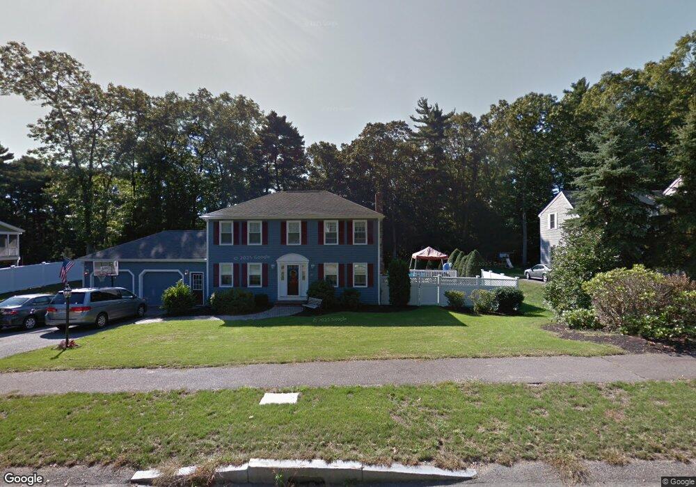
10 Caesar Chelor Dr Wrentham, MA 02093
Estimated Value: $827,344 - $1,015,000
4
Beds
4
Baths
2,588
Sq Ft
$363/Sq Ft
Est. Value
About This Home
This home is located at 10 Caesar Chelor Dr, Wrentham, MA 02093 and is currently estimated at $939,586, approximately $363 per square foot. 10 Caesar Chelor Dr is a home located in Norfolk County with nearby schools including Delaney Elementary School and Charles E Roderick.
Ownership History
Date
Name
Owned For
Owner Type
Purchase Details
Closed on
Jun 30, 2025
Sold by
Smith Richard B
Bought by
Smith Ft and Smith
Current Estimated Value
Purchase Details
Closed on
Apr 1, 2005
Sold by
Smith Kathleen M
Bought by
Smith Richard B
Home Financials for this Owner
Home Financials are based on the most recent Mortgage that was taken out on this home.
Original Mortgage
$328,000
Interest Rate
5.61%
Mortgage Type
Purchase Money Mortgage
Purchase Details
Closed on
Aug 19, 1994
Sold by
Meunter John M and Meunter Amelia K
Bought by
Smith Richard B and Smith Kathleen M
Purchase Details
Closed on
Nov 12, 1992
Sold by
Creek Hollow Bldg Corp
Bought by
Meunier Amelia K and Meunier John M
Create a Home Valuation Report for This Property
The Home Valuation Report is an in-depth analysis detailing your home's value as well as a comparison with similar homes in the area
Purchase History
| Date | Buyer | Sale Price | Title Company |
|---|---|---|---|
| Smith Ft | -- | -- | |
| Smith Ft | -- | -- | |
| Smith Richard B | -- | -- | |
| Smith Richard B | -- | -- | |
| Smith Richard B | -- | -- | |
| Smith Richard B | $189,900 | -- | |
| Smith Richard B | $189,900 | -- | |
| Meunier Amelia K | $161,400 | -- | |
| Meunier Amelia K | $161,400 | -- |
Source: Public Records
Mortgage History
| Date | Status | Borrower | Loan Amount |
|---|---|---|---|
| Previous Owner | Meunier Amelia K | $304,000 | |
| Previous Owner | Smith Richard B | $328,000 |
Source: Public Records
Tax History
| Year | Tax Paid | Tax Assessment Tax Assessment Total Assessment is a certain percentage of the fair market value that is determined by local assessors to be the total taxable value of land and additions on the property. | Land | Improvement |
|---|---|---|---|---|
| 2025 | $8,731 | $753,300 | $342,200 | $411,100 |
| 2024 | $8,471 | $705,900 | $342,200 | $363,700 |
| 2023 | $8,336 | $660,500 | $311,000 | $349,500 |
| 2022 | $7,886 | $576,900 | $282,700 | $294,200 |
| 2021 | $7,784 | $553,200 | $282,700 | $270,500 |
| 2020 | $7,571 | $531,300 | $232,400 | $298,900 |
| 2019 | $7,307 | $517,500 | $232,400 | $285,100 |
| 2018 | $7,215 | $506,700 | $232,700 | $274,000 |
| 2017 | $7,098 | $498,100 | $228,200 | $269,900 |
| 2016 | $6,946 | $486,400 | $221,600 | $264,800 |
| 2015 | $6,858 | $457,800 | $213,000 | $244,800 |
| 2014 | $6,300 | $411,500 | $175,700 | $235,800 |
Source: Public Records
Map
Nearby Homes
- 2 Earle Stewart Ln
- 12 Earle Stewart Ln
- 3 Earle Stewart Ln
- 10 Earle Stewart Ln Unit Lot 5
- 10 Nature View Dr
- 15 Nature View Dr
- 500 Franklin St
- 287 Park St
- 50 Reed Fulton Ave Unit Lot 61
- 246 Forest Grove Ave
- 45 Joshua Rd
- 576 Dedham St
- 11 Weber Farm Rd Unit 11
- 8 Weber Farm Rd Unit 8
- 440 Chestnut St
- 0 W Birch Rd
- 30 Weber Farm Rd Unit 30
- 75 Jordan Rd
- 483 Thurston St
- 8 Ridgefield Rd
- 20 Caesar Chelor Dr
- 35 Caesar Chelor Dr
- 0 Ceasar Chelor
- 25 Caesar Chelor Dr
- 45 Caesar Chelor Dr
- 130 Creek St
- 130 Creek St Unit 2
- 8 Caesar Chelor Dr
- 30 Caesar Chelor Dr
- 15 Caesar Chelor Dr
- 42 Lakeside Ave
- 50 Lakeside Ave
- 46 Lakeside Ave
- 120 Creek St
- 40 Lakeside Ave
- 40 Caesar Chelor Dr
- 55 Caesar Chelor Dr
- 38 Lakeside Ave
- 110 Lakeside Ave
- 5 Caesar Chelor Dr
Your Personal Tour Guide
Ask me questions while you tour the home.