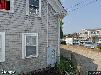
10 Conant St Unit 1 Provincetown, MA 02657
Estimated Value: $1,188,000 - $1,367,000
3
Beds
2
Baths
924
Sq Ft
$1,427/Sq Ft
Est. Value
About This Home
This home is located at 10 Conant St Unit 1, Provincetown, MA 02657 and is currently estimated at $1,318,746, approximately $1,427 per square foot. 10 Conant St Unit 1 is a home located in Barnstable County with nearby schools including Provincetown Schools.
Ownership History
Date
Name
Owned For
Owner Type
Purchase Details
Closed on
Nov 24, 2021
Sold by
10 Conant Street Rt and Dougal
Bought by
Conant Provincetown Llc
Current Estimated Value
Purchase Details
Closed on
Oct 9, 2013
Sold by
10 Conant Street Rt and Dougal
Bought by
10 Conant Street Rt and Dougal
Home Financials for this Owner
Home Financials are based on the most recent Mortgage that was taken out on this home.
Original Mortgage
$335,000
Interest Rate
4.29%
Create a Home Valuation Report for This Property
The Home Valuation Report is an in-depth analysis detailing your home's value as well as a comparison with similar homes in the area
Home Values in the Area
Average Home Value in this Area
Purchase History
| Date | Buyer | Sale Price | Title Company |
|---|---|---|---|
| Conant Provincetown Llc | $1,479,300 | None Available | |
| 10 Conant Street Rt | -- | -- | |
| 10 Conant Street Rt | -- | -- |
Source: Public Records
Mortgage History
| Date | Status | Borrower | Loan Amount |
|---|---|---|---|
| Previous Owner | 10 Conant Street Rt | $335,000 | |
| Previous Owner | 10 Conant Street Rt | $335,000 | |
| Previous Owner | Dougal William P | $259,000 |
Source: Public Records
Tax History Compared to Growth
Tax History
| Year | Tax Paid | Tax Assessment Tax Assessment Total Assessment is a certain percentage of the fair market value that is determined by local assessors to be the total taxable value of land and additions on the property. | Land | Improvement |
|---|---|---|---|---|
| 2025 | $6,130 | $1,094,700 | $0 | $1,094,700 |
| 2024 | $5,765 | $1,033,200 | $0 | $1,033,200 |
| 2023 | $5,327 | $890,800 | $0 | $890,800 |
| 2022 | $5,210 | $782,300 | $0 | $782,300 |
| 2021 | $5,201 | $734,600 | $0 | $734,600 |
| 2020 | $4,721 | $713,200 | $0 | $713,200 |
| 2019 | $4,753 | $673,300 | $0 | $673,300 |
| 2018 | $4,179 | $561,000 | $0 | $561,000 |
| 2017 | $4,161 | $539,700 | $0 | $539,700 |
| 2016 | $4,070 | $521,800 | $0 | $521,800 |
| 2015 | $3,776 | $511,600 | $0 | $511,600 |
Source: Public Records
Map
Nearby Homes
- 140 Commercial St
- 147 Commercial St Unit UL7
- 147 Commercial St Unit L7
- 9 Bradford St
- 11 Central St Unit 1
- 165 Commercial St Unit 4
- 54 Bradford St Unit 2-3
- 54 Bradford St Unit C
- 176 Commercial St Unit 2
- 109 Commercial St
- 4 Carver St
- 3 Race Rd Unit C
- 3 Race Rd Unit UC
- 27 Court St Unit PF
- 27 Court St Pf
- 36 Shank Painter Rd Unit 11
- 56A Franklin St
- 74 Commercial St
- 64 Franklin St Unit UD
- 73 1/2 Commercial St Unit Neptune
- 10 Conant St Unit 2
- 10 Conant St Unit 1
- 9 Montello St
- 11 Conant St Unit 3
- 11 Conant St Unit 2
- 11 Conant St Unit 1
- 11 Conant St
- 8 Conant St Unit 3
- 8 Conant St Unit 2
- 8 Conant St Unit 1
- 8 Conant St Unit PE
- 3 Conant St
- 7 Conant St Unit 1-4
- 7 Conant St Unit 2
- 7 Conant St Unit 1
- 7 Conant St Unit 3
- 7 Conant St Unit 4
- 8 Montello St
- 8 Montello St Unit 1&2
- 6 Conant St