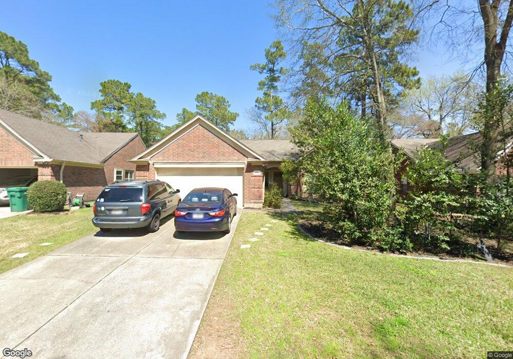
10 Crested Cloud Ct Spring, TX 77380
Grogan's Mill NeighborhoodEstimated Value: $345,786 - $411,000
4
Beds
3
Baths
1,918
Sq Ft
$202/Sq Ft
Est. Value
About This Home
This home is located at 10 Crested Cloud Ct, Spring, TX 77380 and is currently estimated at $386,697, approximately $201 per square foot. 10 Crested Cloud Ct is a home located in Montgomery County with nearby schools including Hailey Elementary School, W.D Wilkerson Intermediate School, and Knox J High School.
Ownership History
Date
Name
Owned For
Owner Type
Purchase Details
Closed on
Jun 8, 2022
Sold by
Davis Linda Boyd
Bought by
Davis Linda Boyd and Davis Ronald R
Current Estimated Value
Purchase Details
Closed on
Oct 26, 2005
Sold by
Mcfail Gilda and George Darryl Lamont
Bought by
Davis Ronald R and Davis Linda B
Home Financials for this Owner
Home Financials are based on the most recent Mortgage that was taken out on this home.
Original Mortgage
$70,000
Interest Rate
6.04%
Mortgage Type
Fannie Mae Freddie Mac
Purchase Details
Closed on
Dec 10, 1992
Sold by
Pulte Homes Of Tx Lp
Bought by
Davis Ronald R and Davis Linda B
Purchase Details
Closed on
Aug 3, 1992
Sold by
Woodlands Land Dev Lp
Bought by
Davis Ronald R and Davis Linda B
Create a Home Valuation Report for This Property
The Home Valuation Report is an in-depth analysis detailing your home's value as well as a comparison with similar homes in the area
Home Values in the Area
Average Home Value in this Area
Purchase History
| Date | Buyer | Sale Price | Title Company |
|---|---|---|---|
| Davis Linda Boyd | -- | None Listed On Document | |
| Davis Ronald R | -- | -- | |
| Davis Ronald R | -- | -- | |
| Davis Ronald R | -- | -- |
Source: Public Records
Mortgage History
| Date | Status | Borrower | Loan Amount |
|---|---|---|---|
| Previous Owner | Davis Ronald R | $70,000 |
Source: Public Records
Tax History
| Year | Tax Paid | Tax Assessment Tax Assessment Total Assessment is a certain percentage of the fair market value that is determined by local assessors to be the total taxable value of land and additions on the property. | Land | Improvement |
|---|---|---|---|---|
| 2025 | $1,456 | $324,486 | -- | -- |
| 2024 | $1,373 | $294,987 | -- | -- |
| 2023 | $1,373 | $268,170 | $50,000 | $260,970 |
| 2022 | $4,927 | $243,790 | $50,000 | $224,550 |
| 2021 | $4,835 | $221,630 | $15,000 | $206,630 |
| 2020 | $5,199 | $228,230 | $15,000 | $219,550 |
| 2019 | $4,884 | $207,480 | $15,000 | $192,480 |
| 2018 | $3,702 | $207,480 | $15,000 | $192,480 |
| 2017 | $4,945 | $207,480 | $15,000 | $192,480 |
| 2016 | $4,832 | $202,740 | $15,000 | $208,820 |
| 2015 | $2,793 | $184,310 | $15,000 | $201,330 |
| 2014 | $2,793 | $167,550 | $15,000 | $152,550 |
Source: Public Records
Map
Nearby Homes
- 19 Tulip Hill Ct
- 22 Camberwell Ct
- 9 S Brook Pebble Ct
- 19 Evening Song Ct
- 37 Rockfern Ct
- 34 Green Bough Ct
- 22 S Rain Forest Ct
- 3 Rain Walk Ct
- 56 N Morningwood Ct
- 49 Country Forest Ct
- 10 S Greenbud Ct
- 8 N Greenbud Ct
- 2005 Carlson Creek Dr
- 118 Angel Leaf Rd
- 205 Grogans Point Rd
- 4 Sawmill Grove Ln
- 25234 Calhoun Creek Dr
- 12224 Gun Oak Place
- 1 Laurel Oak Place
- 1237 Pruitt Rd
- 14 Crested Cloud Ct
- 6 Crested Cloud Ct
- 11 Cirrus Ct
- 15 Cirrus Ct
- 7 Cirrus Ct
- 2 Crested Cloud Ct
- 18 Crested Cloud Ct
- 11 Crested Cloud Ct
- 3 Cirrus Ct
- 19 Cirrus Ct
- 3 Crested Cloud Ct
- 15 Crested Cloud Ct
- 34 Elm Branch Ct
- 19 Crested Cloud Ct
- 10 Cirrus Ct
- 19 S Elm Branch Place
- 14 Cirrus Ct
- 2 Cirrus Ct
- 54 Elm Branch Ct
- 30 S Elm Branch Place
Your Personal Tour Guide
Ask me questions while you tour the home.