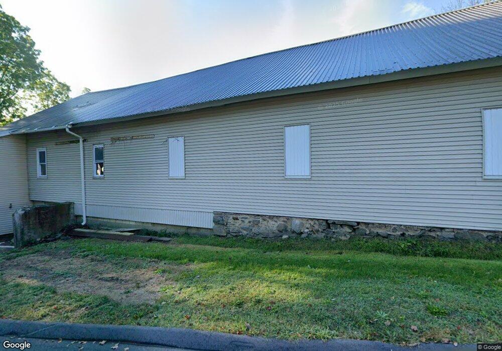
10 E Main St Huntington, MA 01050
Estimated Value: $293,337
1
Bed
1
Bath
3,984
Sq Ft
$74/Sq Ft
Est. Value
About This Home
This home is located at 10 E Main St, Huntington, MA 01050 and is currently estimated at $293,337, approximately $73 per square foot. 10 E Main St is a home located in Hampshire County with nearby schools including Gateway Regional High School.
Ownership History
Date
Name
Owned For
Owner Type
Purchase Details
Closed on
Apr 28, 2025
Sold by
Baillargeon David and Baillargeon Lori A
Bought by
Stoudenmire James
Current Estimated Value
Purchase Details
Closed on
Sep 12, 2012
Sold by
Baillargeon David
Bought by
Baillargeon David and Baillargeon Lori A
Home Financials for this Owner
Home Financials are based on the most recent Mortgage that was taken out on this home.
Original Mortgage
$104,800
Interest Rate
3.57%
Mortgage Type
Commercial
Purchase Details
Closed on
Aug 10, 2005
Sold by
Washburn Donald and Washburn Gene E
Bought by
Curry Deborah and Curry Michael J
Home Financials for this Owner
Home Financials are based on the most recent Mortgage that was taken out on this home.
Original Mortgage
$120,000
Interest Rate
5.54%
Mortgage Type
Commercial
Create a Home Valuation Report for This Property
The Home Valuation Report is an in-depth analysis detailing your home's value as well as a comparison with similar homes in the area
Home Values in the Area
Average Home Value in this Area
Purchase History
| Date | Buyer | Sale Price | Title Company |
|---|---|---|---|
| Stoudenmire James | $180,000 | None Available | |
| Stoudenmire James | $180,000 | None Available | |
| Baillargeon David | -- | -- | |
| Baillargeon David | $123,375 | -- | |
| Baillargeon David P | $123,375 | -- | |
| Baillargeon David P | -- | -- | |
| Baillargeon David | $123,375 | -- | |
| Curry Deborah | $150,000 | -- | |
| Curry Deborah E | $150,000 | -- | |
| Curry Deborah E | $150,000 | -- |
Source: Public Records
Mortgage History
| Date | Status | Borrower | Loan Amount |
|---|---|---|---|
| Previous Owner | Baillargeon David | $104,800 | |
| Previous Owner | Curry Deborah E | $120,000 |
Source: Public Records
Tax History
| Year | Tax Paid | Tax Assessment Tax Assessment Total Assessment is a certain percentage of the fair market value that is determined by local assessors to be the total taxable value of land and additions on the property. | Land | Improvement |
|---|---|---|---|---|
| 2025 | $3,345 | $217,200 | $36,700 | $180,500 |
| 2024 | $3,361 | $214,600 | $36,700 | $177,900 |
| 2023 | $3,325 | $195,000 | $33,400 | $161,600 |
| 2022 | $3,041 | $173,200 | $31,800 | $141,400 |
| 2021 | $3,462 | $173,200 | $31,800 | $141,400 |
| 2020 | $3,394 | $165,400 | $29,000 | $136,400 |
| 2019 | $3,271 | $164,200 | $29,000 | $135,200 |
| 2018 | $3,102 | $162,600 | $34,200 | $128,400 |
| 2017 | $2,935 | $162,600 | $34,200 | $128,400 |
| 2016 | $3,008 | $162,600 | $34,200 | $128,400 |
| 2015 | $2,757 | $160,100 | $34,200 | $125,900 |
Source: Public Records
Map
Nearby Homes
- 24 Worthington Rd
- 13 Basket St
- 0 Lakeville Dam Rd Unit 25269273
- 0 Lakeville Dam Rd Unit 73445764
- 25 Basket St
- 49 Old Chester Rd
- Lot 2 Jourdan Rd
- Lot 9 Jourdan Rd
- 0 E River Rd Lot 13 Map 409 Unit 72690617
- 0 Russell Stage Rd
- 127 Pond Brook Rd
- 6 Blueberry Ln
- 312 Fomer Rd
- 170 Timberidge Dr
- 30 Gore Rd
- 0 Old Chester Rd (Rear)
- 0 Address Withheld Unit 73485702
- 7 Quigley Rd
- 254 Route 20
- 6 Maple St
Your Personal Tour Guide
Ask me questions while you tour the home.