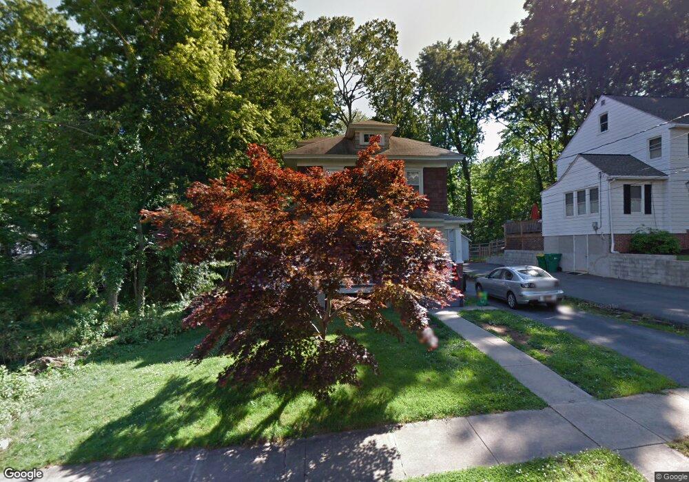
10 Forrest Ave Claymont, DE 19703
Estimated Value: $262,000 - $320,681
3
Beds
1
Bath
1,493
Sq Ft
$194/Sq Ft
Est. Value
About This Home
This home is located at 10 Forrest Ave, Claymont, DE 19703 and is currently estimated at $289,420, approximately $193 per square foot. 10 Forrest Ave is a home located in New Castle County with nearby schools including Claymont Elementary School, Talley Middle School, and Brandywine High School.
Ownership History
Date
Name
Owned For
Owner Type
Purchase Details
Closed on
Jun 18, 2007
Sold by
Oneil John E and Eggink Charlotte A Oneil
Bought by
Lawson Michael and Lawson Amos
Current Estimated Value
Home Financials for this Owner
Home Financials are based on the most recent Mortgage that was taken out on this home.
Original Mortgage
$159,000
Outstanding Balance
$97,028
Interest Rate
6.14%
Mortgage Type
Purchase Money Mortgage
Estimated Equity
$192,392
Create a Home Valuation Report for This Property
The Home Valuation Report is an in-depth analysis detailing your home's value as well as a comparison with similar homes in the area
Home Values in the Area
Average Home Value in this Area
Purchase History
| Date | Buyer | Sale Price | Title Company |
|---|---|---|---|
| Lawson Michael | $159,000 | None Available |
Source: Public Records
Mortgage History
| Date | Status | Borrower | Loan Amount |
|---|---|---|---|
| Open | Lawson Michael | $159,000 |
Source: Public Records
Tax History Compared to Growth
Tax History
| Year | Tax Paid | Tax Assessment Tax Assessment Total Assessment is a certain percentage of the fair market value that is determined by local assessors to be the total taxable value of land and additions on the property. | Land | Improvement |
|---|---|---|---|---|
| 2024 | $1,975 | $50,600 | $8,200 | $42,400 |
| 2023 | $1,810 | $50,600 | $8,200 | $42,400 |
| 2022 | $1,831 | $50,600 | $8,200 | $42,400 |
| 2021 | $1,830 | $50,600 | $8,200 | $42,400 |
| 2020 | $1,829 | $50,600 | $8,200 | $42,400 |
| 2019 | $2,353 | $50,600 | $8,200 | $42,400 |
| 2018 | $1,751 | $50,600 | $8,200 | $42,400 |
| 2017 | $1,724 | $50,600 | $8,200 | $42,400 |
| 2016 | $1,720 | $50,600 | $8,200 | $42,400 |
| 2015 | $1,585 | $50,600 | $8,200 | $42,400 |
| 2014 | $1,585 | $50,600 | $8,200 | $42,400 |
Source: Public Records
Map
Nearby Homes
- 3 Forrest Ave
- 8 Commonwealth Ave
- 119 Commonwealth Ave
- 37 2nd Ave
- 314 Castle Ave
- 12 Wistar St
- 48 4th Ave
- 50 & 52 Lawson Ave
- 9 Grubbs Landing Rd
- 3005 Greenshire Ave
- 3048 Greenshire Ave
- 2700 Philadelphia Pike
- 108 Delaware Ave
- 2810 Green St
- 3745 Green St
- 206 Pennsylvania Ave
- 659 Mccomb Place
- 3858 Green St
- 605 Delancey Place
- 447 Lenape Way
- 12 Forrest Ave
- 8 Forrest Ave
- 9 Forrest Ave
- 7 Forrest Ave
- 11 Forrest Ave
- 4 Forrest Ave
- 5 Forrest Ave
- 2 Forrest Ave
- 14 Forrest Ave
- 17 Cathedral Ave
- 15 1/2 Forrest Ave
- 15 Forrest Ave
- 12 Stockdale Ave
- 8 Stockdale Ave
- 6 Stockdale Ave
- 16 Forrest Ave
- 1 Woodsedge
- 4 Stockdale Ave
- 18 Forrest Ave
- 94 Governor Printz Blvd Unit 7