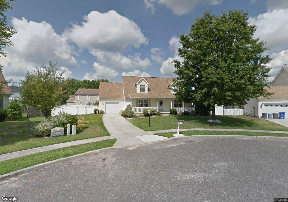
10 Hogate Ct Clayton, NJ 08312
Estimated Value: $323,938 - $417,000
--
Bed
--
Bath
1,792
Sq Ft
$210/Sq Ft
Est. Value
About This Home
This home is located at 10 Hogate Ct, Clayton, NJ 08312 and is currently estimated at $376,735, approximately $210 per square foot. 10 Hogate Ct is a home located in Gloucester County with nearby schools including Herma S. Simmons Elementary School, Clayton Middle School, and Clayton High School.
Ownership History
Date
Name
Owned For
Owner Type
Purchase Details
Closed on
Jun 10, 2009
Sold by
Scarduzio Patricia A
Bought by
Scarduzio Patricia A
Current Estimated Value
Purchase Details
Closed on
Mar 20, 1998
Sold by
Sansalone Stephen J and Sansalone Elizabeth R
Bought by
Scarduzio Michael B and Scarduzio Patricia A
Home Financials for this Owner
Home Financials are based on the most recent Mortgage that was taken out on this home.
Original Mortgage
$98,400
Outstanding Balance
$22,838
Interest Rate
10%
Estimated Equity
$353,897
Purchase Details
Closed on
Sep 29, 1993
Sold by
D K M Building
Bought by
Sansalone Stephen J and Sansalone Elizabeth
Home Financials for this Owner
Home Financials are based on the most recent Mortgage that was taken out on this home.
Original Mortgage
$67,000
Interest Rate
6.87%
Create a Home Valuation Report for This Property
The Home Valuation Report is an in-depth analysis detailing your home's value as well as a comparison with similar homes in the area
Home Values in the Area
Average Home Value in this Area
Purchase History
| Date | Buyer | Sale Price | Title Company |
|---|---|---|---|
| Scarduzio Patricia A | -- | None Available | |
| Scarduzio Michael B | $123,000 | Welchert Title Agency | |
| Sansalone Stephen J | $102,400 | -- |
Source: Public Records
Mortgage History
| Date | Status | Borrower | Loan Amount |
|---|---|---|---|
| Open | Scarduzio Michael B | $98,400 | |
| Previous Owner | Sansalone Stephen J | $67,000 |
Source: Public Records
Tax History Compared to Growth
Tax History
| Year | Tax Paid | Tax Assessment Tax Assessment Total Assessment is a certain percentage of the fair market value that is determined by local assessors to be the total taxable value of land and additions on the property. | Land | Improvement |
|---|---|---|---|---|
| 2025 | $7,687 | $310,600 | $72,000 | $238,600 |
| 2024 | $6,955 | $310,600 | $72,000 | $238,600 |
| 2023 | $6,955 | $172,100 | $44,300 | $127,800 |
| 2022 | $6,879 | $172,100 | $44,300 | $127,800 |
| 2021 | $6,107 | $172,100 | $44,300 | $127,800 |
| 2020 | $6,810 | $172,100 | $44,300 | $127,800 |
| 2019 | $6,695 | $172,100 | $44,300 | $127,800 |
| 2018 | $6,600 | $172,100 | $44,300 | $127,800 |
| 2017 | $6,488 | $172,100 | $44,300 | $127,800 |
| 2016 | $5,919 | $172,100 | $44,300 | $127,800 |
| 2015 | $5,730 | $172,100 | $44,300 | $127,800 |
| 2014 | $5,513 | $172,100 | $44,300 | $127,800 |
Source: Public Records
Map
Nearby Homes
- 34 Fisler Dr
- 161 Deschler Blvd
- 34 Morgan Dr
- 109 Holly Rd
- 100 Stage Coach Rd
- 271 Kille Rd
- 201 Luray Dr
- 664 Scotland Run Ave
- 613 Cedar Ave
- 2020 Paddock Ln
- Cadence Plan at Blaze Mill
- Ballad Plan at Blaze Mill
- Aria Plan at Blaze Mill
- 23 Turnberry Dr
- 7 Augusta Ct
- 1201 Whispering Woods Dr
- 960 Butler Dr
- 6 Dubois Ave
- 13 W Dehart Ave
- 35 W Dehart Ave