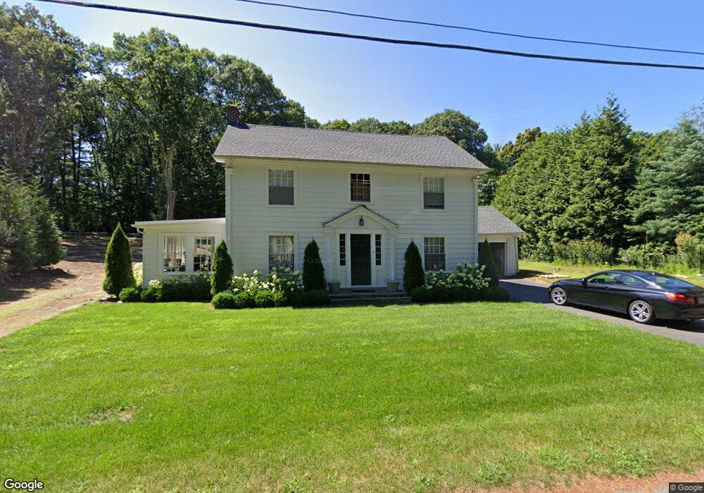
10 Irving Rd Weston, MA 02493
Estimated Value: $1,340,893 - $1,801,000
3
Beds
2
Baths
2,083
Sq Ft
$746/Sq Ft
Est. Value
About This Home
This home is located at 10 Irving Rd, Weston, MA 02493 and is currently estimated at $1,552,973, approximately $745 per square foot. 10 Irving Rd is a home located in Middlesex County with nearby schools including Country Elementary School, Woodland Elementary School, and Field Elementary School.
Ownership History
Date
Name
Owned For
Owner Type
Purchase Details
Closed on
Aug 15, 2017
Sold by
Simler David A and Reno Stephen A
Bought by
Oconnor Timothy J and Oconnor Dianne M
Current Estimated Value
Purchase Details
Closed on
Jun 26, 1973
Bought by
Simler David A
Create a Home Valuation Report for This Property
The Home Valuation Report is an in-depth analysis detailing your home's value as well as a comparison with similar homes in the area
Home Values in the Area
Average Home Value in this Area
Purchase History
| Date | Buyer | Sale Price | Title Company |
|---|---|---|---|
| Oconnor Timothy J | $850,000 | -- | |
| Simler David A | -- | -- |
Source: Public Records
Mortgage History
| Date | Status | Borrower | Loan Amount |
|---|---|---|---|
| Previous Owner | Simler David A | $370,500 | |
| Previous Owner | Simler David A | $125,000 | |
| Previous Owner | Simler David A | $55,000 |
Source: Public Records
Tax History
| Year | Tax Paid | Tax Assessment Tax Assessment Total Assessment is a certain percentage of the fair market value that is determined by local assessors to be the total taxable value of land and additions on the property. | Land | Improvement |
|---|---|---|---|---|
| 2025 | $10,783 | $971,400 | $687,200 | $284,200 |
| 2024 | $10,661 | $958,700 | $687,200 | $271,500 |
| 2023 | $10,926 | $922,800 | $687,200 | $235,600 |
| 2022 | $10,602 | $827,600 | $644,400 | $183,200 |
| 2021 | $6,265 | $789,600 | $614,900 | $174,700 |
| 2020 | $10,134 | $789,900 | $615,200 | $174,700 |
| 2019 | $9,390 | $745,800 | $573,600 | $172,200 |
| 2018 | $10,070 | $745,800 | $573,600 | $172,200 |
| 2017 | $9,260 | $746,800 | $574,600 | $172,200 |
| 2016 | $9,081 | $746,800 | $574,600 | $172,200 |
| 2015 | $7,560 | $615,600 | $448,300 | $167,300 |
Source: Public Records
Map
Nearby Homes
- 1 Pine Summit Cir
- 741 Boston Post Rd
- 30 Warren Ave
- 16 Livermore Ln
- 16 Livermore Ln Unit 16
- 15 Claridge Dr
- 21 Jericho Rd Unit 21
- 823 Boston Post Rd
- 180 Highland St
- 9 Sanderson Ln
- 21 Westerly Rd
- 133 Wellesley St
- 135 Wellesley St
- 131 Wellesley St
- 180 Ash St
- 10 Audubon Rd
- 253 Highland St
- 226 Ash St
- 302 Concord Rd
- 23 Covered Bridge Ln
- 14 Irving Rd
- 8 Irving Rd
- 7 Irving Rd
- 706 Boston Post Rd
- 6 Irving Rd
- 5 Irving Rd
- 5 Irving Rd Unit 5
- 4 Irving Rd
- 4 Irving Rd Unit 4
- 707 Boston Post Rd
- 715 Boston Post Rd
- 11 Highland St
- 15 Highland St
- 6 Gambrill Ln Unit 6P
- 705 Boston Post Rd
- 2 Fillmore Place Unit 2FM
- 8 Fillmore Place Unit 8FC
- 8 Fillmore Place Unit 8FM
- 8 Fillmore Place Unit 8
- 8 Gambrill Ln Unit 8GL
Your Personal Tour Guide
Ask me questions while you tour the home.