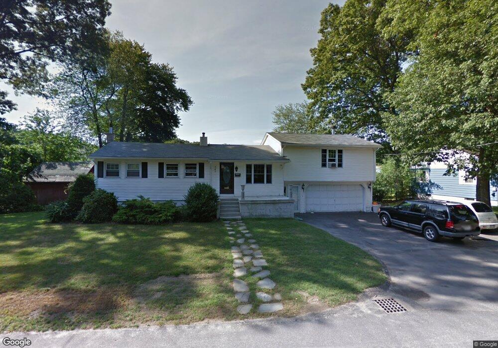
10 John St Millbury, MA 01527
Estimated Value: $485,000 - $525,000
3
Beds
4
Baths
1,547
Sq Ft
$327/Sq Ft
Est. Value
About This Home
This home is located at 10 John St, Millbury, MA 01527 and is currently estimated at $506,228, approximately $327 per square foot. 10 John St is a home located in Worcester County with nearby schools including Elmwood Street Elementary School, Raymond E. Shaw Elementary School, and Millbury Junior/Senior High School.
Ownership History
Date
Name
Owned For
Owner Type
Purchase Details
Closed on
Jun 15, 2011
Sold by
Holland Daniel P and Holland Gina M
Bought by
Holland Daniel P
Current Estimated Value
Home Financials for this Owner
Home Financials are based on the most recent Mortgage that was taken out on this home.
Original Mortgage
$125,000
Outstanding Balance
$86,307
Interest Rate
4.74%
Mortgage Type
Purchase Money Mortgage
Estimated Equity
$419,921
Purchase Details
Closed on
Oct 4, 2002
Sold by
Holland Gerald and Holland Mathilda A
Bought by
Holland Daniel P and Holland Gina M
Create a Home Valuation Report for This Property
The Home Valuation Report is an in-depth analysis detailing your home's value as well as a comparison with similar homes in the area
Home Values in the Area
Average Home Value in this Area
Purchase History
| Date | Buyer | Sale Price | Title Company |
|---|---|---|---|
| Holland Daniel P | -- | -- | |
| Holland Daniel P | -- | -- | |
| Holland Daniel P | -- | -- | |
| Holland Daniel P | $225,000 | -- | |
| Holland Daniel P | $225,000 | -- |
Source: Public Records
Mortgage History
| Date | Status | Borrower | Loan Amount |
|---|---|---|---|
| Open | Holland Daniel P | $125,000 | |
| Closed | Holland Daniel P | $125,000 |
Source: Public Records
Tax History Compared to Growth
Tax History
| Year | Tax Paid | Tax Assessment Tax Assessment Total Assessment is a certain percentage of the fair market value that is determined by local assessors to be the total taxable value of land and additions on the property. | Land | Improvement |
|---|---|---|---|---|
| 2025 | $5,830 | $435,400 | $114,000 | $321,400 |
| 2024 | $5,361 | $405,200 | $105,600 | $299,600 |
| 2023 | $4,823 | $333,800 | $74,100 | $259,700 |
| 2022 | $4,602 | $306,800 | $74,100 | $232,700 |
| 2021 | $1,146 | $292,300 | $74,100 | $218,200 |
| 2020 | $4,398 | $286,900 | $74,100 | $212,800 |
| 2019 | $4,237 | $267,300 | $67,300 | $200,000 |
| 2018 | $5,007 | $243,800 | $67,300 | $176,500 |
| 2017 | $3,833 | $233,300 | $67,300 | $166,000 |
| 2016 | $3,545 | $215,400 | $67,300 | $148,100 |
| 2015 | $3,560 | $216,300 | $71,500 | $144,800 |
| 2014 | $3,379 | $197,600 | $71,500 | $126,100 |
Source: Public Records
Map
Nearby Homes
- 12 Irene Ct
- 86 Wheelock Ave
- 11 Maplewood Rd
- 11 Westview Ave
- 2 Diane St
- 27 A-B Grafton St
- 3 May St
- 3 Stidsen Way
- 1 Pineland Ave
- 1 Broadmeadow Ave
- 232 Weatherstone Dr
- 76 Weatherstone Dr
- 90 Macarthur Dr
- 46 John Dr Unit 46
- 21 Lordvale Blvd Unit 406
- 330 Millbury Ave
- 5 Edward Dr
- 39 Pointe Rok Dr Unit 39
- 497 Massasoit Rd
- 76 Samuel Dr