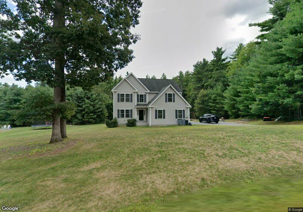
10 Laurel Crest Dr Brookline, NH 03033
Estimated Value: $769,722 - $889,000
4
Beds
3
Baths
3,062
Sq Ft
$268/Sq Ft
Est. Value
About This Home
This home is located at 10 Laurel Crest Dr, Brookline, NH 03033 and is currently estimated at $819,431, approximately $267 per square foot. 10 Laurel Crest Dr is a home with nearby schools including Richard Maghakian Memorial School, Captain Samuel Douglass Academy, and Hollis-Brookline Middle School.
Ownership History
Date
Name
Owned For
Owner Type
Purchase Details
Closed on
Oct 29, 2013
Sold by
Laurelcrest Baldwin Rt and Patenaude Albert W
Bought by
Boxall Jeffrey D and Webster Jessica M
Current Estimated Value
Create a Home Valuation Report for This Property
The Home Valuation Report is an in-depth analysis detailing your home's value as well as a comparison with similar homes in the area
Home Values in the Area
Average Home Value in this Area
Purchase History
| Date | Buyer | Sale Price | Title Company |
|---|---|---|---|
| Boxall Jeffrey D | $358,200 | -- | |
| Boxall Jeffrey D | $358,200 | -- |
Source: Public Records
Mortgage History
| Date | Status | Borrower | Loan Amount |
|---|---|---|---|
| Open | Boxall Jeffrey D | $346,000 | |
| Previous Owner | Boxall Jeffrey D | $30,000 |
Source: Public Records
Tax History Compared to Growth
Tax History
| Year | Tax Paid | Tax Assessment Tax Assessment Total Assessment is a certain percentage of the fair market value that is determined by local assessors to be the total taxable value of land and additions on the property. | Land | Improvement |
|---|---|---|---|---|
| 2024 | $15,515 | $686,200 | $197,200 | $489,000 |
| 2023 | $14,259 | $686,200 | $197,200 | $489,000 |
| 2022 | $12,488 | $420,200 | $118,800 | $301,400 |
| 2021 | $12,009 | $420,200 | $118,800 | $301,400 |
| 2020 | $11,682 | $420,200 | $118,800 | $301,400 |
| 2019 | $12,551 | $420,200 | $118,800 | $301,400 |
| 2018 | $12,421 | $420,200 | $118,800 | $301,400 |
| 2017 | $11,348 | $344,500 | $94,000 | $250,500 |
| 2016 | $11,217 | $344,500 | $94,000 | $250,500 |
| 2015 | $10,697 | $344,500 | $94,000 | $250,500 |
| 2014 | $11,317 | $344,500 | $94,000 | $250,500 |
| 2013 | $2,527 | $79,900 | $79,900 | $0 |
Source: Public Records
Map
Nearby Homes
- 15 N End Rd
- 364 Townsend Hill Rd
- 7 Winterberry Rd
- 9 Winterberry Rd
- 55 Oak Hill Rd
- 46 Oak Hill Rd
- 0 Brookline St
- 6 High Oaks Path
- 64 Meadow Rd
- 21 Cranberry St
- 6 Flint Meadow Dr
- 110 Haynes Rd
- 22 Hobart Hill Rd
- 1235 Townsend Rd
- 91 Highland St
- 75 Highland St
- 167 Route 13
- 10 Stearns Ave
- 28A Rocky Pond Rd
- 179 Brookline St
- 8 Laurel Crest Dr
- 2 Mead Dr
- 7 Laurel Crest Dr
- 6 Laurel Crest Dr
- 9 Laurel Crest Dr
- 12 Baldwin Dr
- 11 Laurelcrest Dr
- 4 Captain Douglas Dr
- 4 Captain Douglas Dr
- 4 Laurel Crest Dr
- 11 Laurel Crest Dr
- 1 Baldwin Ln Unit 12
- 12 Laurel Crest Dr
- 2 Laurel Crest Dr
- 2 Laurel Crest Dr
- 4 Baldwin Ln
- 4 Baldwin Dr
- 13 Laurel Crest Dr
- 13 Laurelcrest Dr