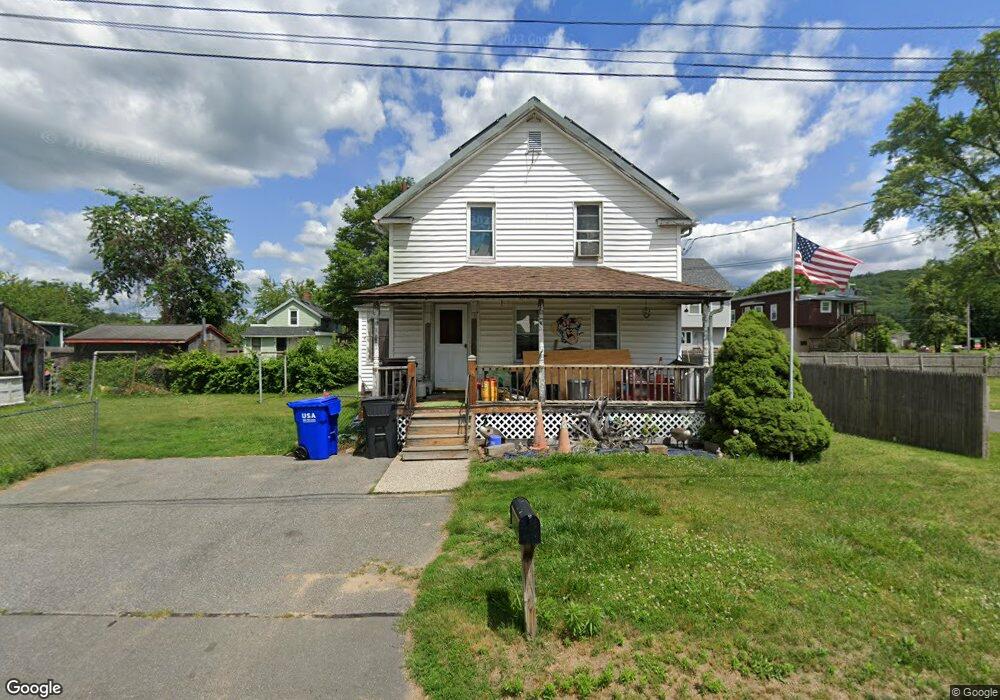
10 Lewandowski Ave Easthampton, MA 01027
Estimated Value: $258,000 - $288,000
2
Beds
2
Baths
1,056
Sq Ft
$261/Sq Ft
Est. Value
About This Home
This home is located at 10 Lewandowski Ave, Easthampton, MA 01027 and is currently estimated at $275,901, approximately $261 per square foot. 10 Lewandowski Ave is a home located in Hampshire County with nearby schools including Easthampton High School, Hilltown Cooperative Charter Public School, and Tri-County Schools.
Ownership History
Date
Name
Owned For
Owner Type
Purchase Details
Closed on
Aug 14, 2000
Sold by
Guyette Paul F
Bought by
Duprey Michelle M and Gougeon David D
Current Estimated Value
Home Financials for this Owner
Home Financials are based on the most recent Mortgage that was taken out on this home.
Original Mortgage
$71,200
Interest Rate
8.21%
Mortgage Type
Purchase Money Mortgage
Create a Home Valuation Report for This Property
The Home Valuation Report is an in-depth analysis detailing your home's value as well as a comparison with similar homes in the area
Home Values in the Area
Average Home Value in this Area
Purchase History
| Date | Buyer | Sale Price | Title Company |
|---|---|---|---|
| Duprey Michelle M | $96,000 | -- |
Source: Public Records
Mortgage History
| Date | Status | Borrower | Loan Amount |
|---|---|---|---|
| Open | Duprey Michelle M | $112,700 | |
| Closed | Duprey Michelle M | $71,200 |
Source: Public Records
Tax History
| Year | Tax Paid | Tax Assessment Tax Assessment Total Assessment is a certain percentage of the fair market value that is determined by local assessors to be the total taxable value of land and additions on the property. | Land | Improvement |
|---|---|---|---|---|
| 2025 | $3,316 | $242,600 | $83,400 | $159,200 |
| 2024 | $3,200 | $236,000 | $80,900 | $155,100 |
| 2023 | $2,419 | $165,100 | $63,800 | $101,300 |
| 2022 | $2,729 | $165,100 | $63,800 | $101,300 |
| 2021 | $2,985 | $170,200 | $63,800 | $106,400 |
| 2020 | $2,932 | $165,100 | $63,800 | $101,300 |
| 2019 | $2,407 | $155,700 | $63,800 | $91,900 |
| 2018 | $2,320 | $145,000 | $60,300 | $84,700 |
| 2017 | $2,261 | $139,500 | $57,900 | $81,600 |
| 2016 | $2,254 | $144,600 | $57,900 | $86,700 |
| 2015 | $2,191 | $144,600 | $57,900 | $86,700 |
Source: Public Records
Map
Nearby Homes
- 29 Parsons St Unit 1
- 18-20 Oakdale Place
- 12 Glen Cove Place Unit B
- 10 Glen Cove Place Unit A
- 2 Oak St
- 33 Knipfer Ave
- 40 Clark St
- 4 Gaugh St
- 19 Nicols Way Unit 19
- 7 Union Ct
- 26 Winter St
- 11 Dragon Cir
- 6 Wilton Rd
- 385 Main St
- 41 South St Unit 11
- M143 &152 Glendale St
- 336 Main St
- 131 West St Unit 131
- 6 S St & Abutting Lots
- 296 Old Wilson Rd
- 78 Parsons St
- 72 Parsons St
- 7 Lewandowski Ave
- 117 Everett St
- 68 Parsons St
- 159 Everett St Unit 1
- 80 Parsons St Unit 82
- 5 Broderick St
- 5 Broderick St Unit 2nd Fl Left
- 157 Everett St
- 7 Broderick St
- 69 Parsons St
- 168 Everett St
- 8 Maine Ave
- 6 Maine Ave
- 4 Maine Ave
- 8 Maine Ave Unit 8
- 64 Parsons St Unit B
- 64 Parsons St
- 3 Broderick St
Your Personal Tour Guide
Ask me questions while you tour the home.