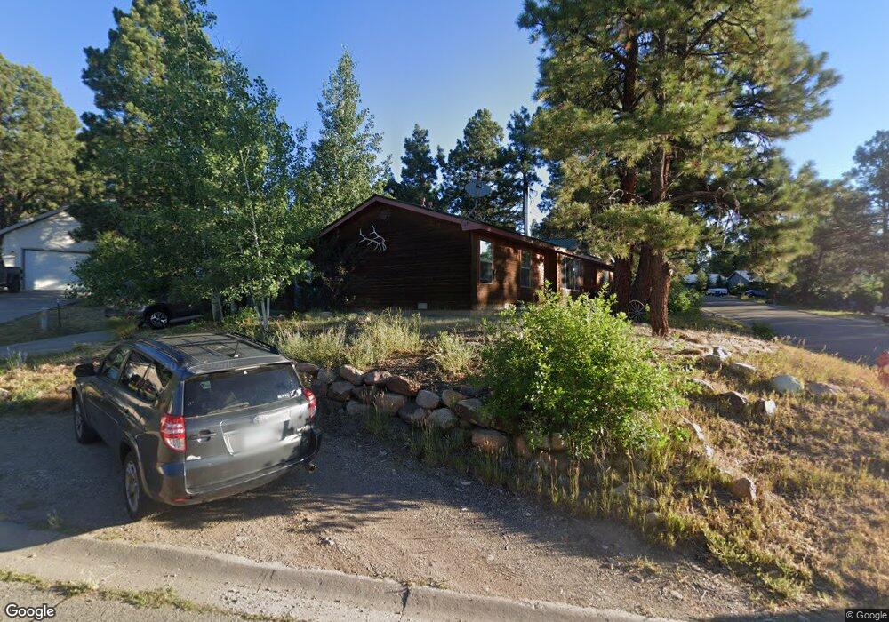
10 Locust Ct Durango, CO 81303
Durango West NeighborhoodEstimated Value: $408,000 - $503,000
3
Beds
2
Baths
1,432
Sq Ft
$317/Sq Ft
Est. Value
About This Home
This home is located at 10 Locust Ct, Durango, CO 81303 and is currently estimated at $453,667, approximately $316 per square foot. 10 Locust Ct is a home located in La Plata County with nearby schools including Park Elementary School, Escalante Middle School, and Durango High School.
Ownership History
Date
Name
Owned For
Owner Type
Purchase Details
Closed on
Jun 23, 2007
Sold by
Funk Ann M
Bought by
Gaiovnik Ann M and Andersen Ii Dana W
Current Estimated Value
Home Financials for this Owner
Home Financials are based on the most recent Mortgage that was taken out on this home.
Original Mortgage
$80,288
Interest Rate
6.71%
Mortgage Type
Future Advance Clause Open End Mortgage
Purchase Details
Closed on
May 26, 2000
Bought by
Gaiovnik Ann M
Create a Home Valuation Report for This Property
The Home Valuation Report is an in-depth analysis detailing your home's value as well as a comparison with similar homes in the area
Home Values in the Area
Average Home Value in this Area
Purchase History
| Date | Buyer | Sale Price | Title Company |
|---|---|---|---|
| Gaiovnik Ann M | -- | Land Title | |
| Gaiovnik Ann M | $74,000 | -- |
Source: Public Records
Mortgage History
| Date | Status | Borrower | Loan Amount |
|---|---|---|---|
| Closed | Gaiovnik Ann M | $80,288 |
Source: Public Records
Tax History
| Year | Tax Paid | Tax Assessment Tax Assessment Total Assessment is a certain percentage of the fair market value that is determined by local assessors to be the total taxable value of land and additions on the property. | Land | Improvement |
|---|---|---|---|---|
| 2025 | $1,192 | $28,770 | $5,020 | $23,750 |
| 2024 | $1,021 | $24,310 | $3,770 | $20,540 |
| 2023 | $1,021 | $27,260 | $4,230 | $23,030 |
| 2022 | $839 | $29,040 | $4,500 | $24,540 |
| 2021 | $843 | $20,330 | $4,370 | $15,960 |
| 2020 | $833 | $20,710 | $4,110 | $16,600 |
| 2019 | $799 | $20,710 | $4,110 | $16,600 |
| 2018 | $740 | $19,200 | $4,140 | $15,060 |
| 2017 | $730 | $19,350 | $4,140 | $15,210 |
| 2016 | $663 | $19,040 | $4,580 | $14,460 |
| 2015 | $994 | $19,040 | $4,580 | $14,460 |
| 2014 | -- | $16,040 | $4,580 | $11,460 |
| 2013 | -- | $16,040 | $4,580 | $11,460 |
Source: Public Records
Map
Nearby Homes
- 173 Canyon Creek Trail
- 178 Canyon Creek Trail
- 199 Timber Dr
- 40 Hidden Ln
- 136 Oak Dr
- 178 Oak Dr
- 678 N Lakeside Dr
- 209 Fir Dr
- TBD Vaquero Way
- 23 Hunter Ct
- 841 Oak Dr
- 21121 Highway 140
- 717 Zane Dr
- 21351 Colorado 140 Unit 7
- 719 Terlun Dr
- 51 Shenandoah Cir
- 351 Cherry Gulch Rd
- 269 North Rd
- 307 Deer Trail Rd
- 111 Rendezvous Trail
- 0 Locust Ct Unit 739380
- 0 Locust Ct Unit 733630
- 0 Locust Ct Unit 658923
- 0 Locust Ct Unit 661793
- 22 Locust Ct
- 13 Hawthorne Cir
- 42 Westridge Rd
- 42 Westridge Rd Unit 42 Westridge Road
- 27 Hawthorne Cir
- 28 Locust Ct
- 58 Westridge Rd
- 58 Westridge Rd Unit Westridge Subdivisio
- 196 Trail Wood Dr
- 31 Locust Ct
- 0 Hawthorne Ct Unit 642308
- 0 Hawthorne Ct Unit 713782
- 0 Hawthorne Ct Unit 720703
- 15 Locust Ct
- 31 Hawthorne Cir
- 25 Locust Ct
Your Personal Tour Guide
Ask me questions while you tour the home.